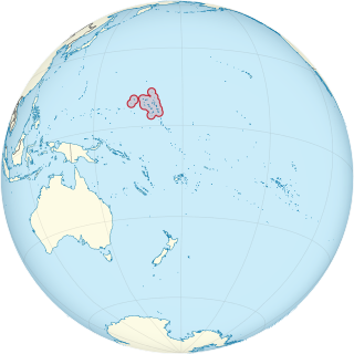
This is a list of the buildings, sites, districts, and objects listed on the National Register of Historic Places in the Marshall Islands. There are currently 4 listed sites located in only three of the 24 atolls that make up the Marshall Islands.

This is a list of the buildings, sites, districts, and objects listed on the National Register of Historic Places in the Northern Mariana Islands. There currently 37 listed sites spread across the four municipalities of the Northern Mariana Islands. There are no sites listed on any of the islands that make up the Northern Islands Municipality.

This is a list of the buildings, sites, districts, and objects listed on the National Register of Historic Places in the Federated States of Micronesia. There are currently 26 listed sites located in all 4 states of the Federated States of Micronesia.

This is a list of the buildings, sites, districts, and objects listed on the National Register of Historic Places in the Republic of Palau. There are currently 6 listed sites located in only four of the sixteen states of Palau.

This is a list of the buildings, sites, districts, and objects listed on the National Register of Historic Places in the United States Virgin Islands. There are currently 87 listed sites spread across 16 of the 20 subdistricts within three islands/districts of the United States Virgin Islands. Four sites are additionally designated National Historic Landmarks and two others as National Historic Sites.

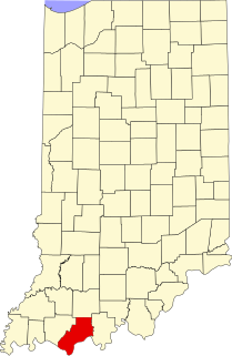
This is a list of the National Register of Historic Places listings in Lake County, Indiana.

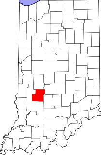
This is a list of the National Register of Historic Places listings in Bartholomew County, Indiana.
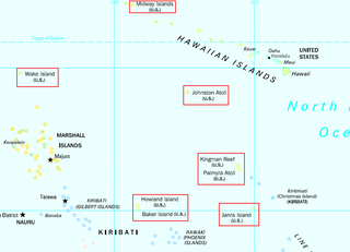
This is a list of the buildings, sites, districts, and objects listed on the National Register of Historic Places across the United States Minor Outlying Islands. There are currently two listed sites located on two of the twelve islands or atolls that make up the Minor Outlying Islands.

This is a list of the National Register of Historic Places listings in Cass County, Indiana.

This is a list of the National Register of Historic Places listings in Montgomery County, Indiana.

This is a list of the National Register of Historic Places listings in Hendricks County, Indiana.

This is a list of the National Register of Historic Places listings in Miami County, Indiana.
This is a list of the National Register of Historic Places listings in Owen County, Indiana.
This is a list of the National Register of Historic Places listings in Spencer County, Indiana.

This is a list of the National Register of Historic Places listings in Grant County, Indiana.
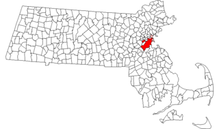
Boston, Massachusetts is home to a large number of listings on the National Register of Historic Places. This list encompasses those locations that are located south of the Massachusetts Turnpike. See National Register of Historic Places listings in northern Boston for listings north of the Turnpike. Properties and districts located elsewhere in Suffolk County's other three municipalities are also listed separately.
The National Register Information System (NRIS) is a database of properties that have been listed on the United States National Register of Historic Places. The database includes more than 84,000 entries of historic sites that are currently listed on the National Register, that were previously listed and later removed, or that are pending listing. The database includes approximately 45 pieces of data for each listed property. Accuracy of the NRIS database may be imperfect. For example, a 2004 paper addressed accuracy of spatial location data for part of the NRIS content.

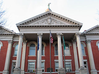
Spotsylvania Court House Historic District is a national historic district located at Spotsylvania, Spotsylvania County, Virginia. The district includes 24 contributing buildings in the historic core of Spotsylvania. The principal building is the Spotsylvania Court House, a two-story Roman Revival style brick building built in 1839-1840 and extensively remodeled in 1901. The front facade features a tetrastyle portico in the Tuscan order. Associated with the courthouse is a late 18th-century jail and office and storage buildings erected in the 1930s. Other notable buildings include the Spottswood Inn, Berea Church (1856), Christ Church (1841), Dabney Farm, J.P.H. Crismond House, Harris House, and Cary Crismond House.

Harbourton is a historic unincorporated community located within Hopewell Township in Mercer County, New Jersey, United States. It is located along County Route 579 at the intersection with Harbourton-Mount Airy Road. The community was added to the National Register of Historic Places in 1974.

Ashmead Village is an unincorporated community in Cheltenham Township, Montgomery County, Pennsylvania, United States. The George K. Heller School, which is listed on the National Register of Historic Places, is located in Ashmead Village.