West Augusta, Virginia

Last updated
West Augusta, Virginia
Unincorporated community
2016-05-19 16 52 52 View east along Shenandoah Mountain Road (U.S. Route 250) in West Augusta, Augusta County, Virginia.jpg
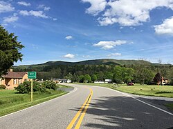
View east along US 250 entering West Augusta
USA Virginia location map.svg
Red pog.svg
West Augusta, Virginia
Usa edcp location map.svg
Red pog.svg
West Augusta, Virginia
Coordinates: 38°16′12″N79°18′28″W / 38.27000°N 79.30778°W / 38.27000; -79.30778 Coordinates: 38°16′12″N79°18′28″W / 38.27000°N 79.30778°W / 38.27000; -79.30778
Country United States
State Virginia
County Augusta
Elevation 1,890 ft (580 m)
Time zone Eastern (EST) (UTC−5)
  Summer (DST) EDT (UTC−4)
ZIP code 24485
Area code(s) 540
GNIS feature ID 1500293 [1]

West Augusta is an unincorporated community in Augusta County, Virginia, United States. West Augusta is located at the intersection of U.S. Route 250 and Virginia State Route 629. [2] The source of the Calfpasture River, which flows through West Augusta, is located near the community to the north. [3]

Augusta County, Virginia County in the United States

Augusta County is a county located in the Shenandoah Valley on the western edge of the U.S. commonwealth of Virginia. It is the second-largest county in Virginia by total area, and it completely surrounds the independent cities of Staunton and Waynesboro. The county seat of Augusta is Staunton, although most of the administrative services have offices in neighboring Verona.

Virginia State of the United States of America

Virginia, officially the Commonwealth of Virginia, is a state in the Southeastern and Mid-Atlantic regions of the United States located between the Atlantic Coast and the Appalachian Mountains. Virginia is nicknamed the "Old Dominion" due to its status as the first English colonial possession established in mainland North America and "Mother of Presidents" because eight U.S. presidents were born there, more than any other state. The geography and climate of the Commonwealth are shaped by the Blue Ridge Mountains and the Chesapeake Bay, which provide habitat for much of its flora and fauna. The capital of the Commonwealth is Richmond; Virginia Beach is the most populous city, and Fairfax County is the most populous political subdivision. The Commonwealth's estimated population as of 2018 is over 8.5 million.

U.S. Route 250 is a route of the United States Numbered Highway System, and is a spur of U.S. Route 50. It currently runs for 514 miles (827 km) from Richmond, Virginia to Sandusky, Ohio. It passes through the states of Virginia, West Virginia, and Ohio. It goes through the cities of Richmond, Charlottesville, Staunton, and Waynesboro, Virginia; and Wheeling, West Virginia. West of Pruntytown, West Virginia, US 250 intersects and forms a short overlap with its parent US 50.

Climate

The climate in this area is characterized by hot, humid summers and generally mild to cool winters. According to the Köppen Climate Classification system, West Augusta has a humid subtropical climate, abbreviated "Cfa" on climate maps. [4]

Humid subtropical climate category in the Köppen climate classification system

A humid subtropical climate is a zone of climate characterized by hot and humid summers, and mild winters. These climates normally lie on the southeast side of all continents, generally between latitudes 25° and 35° and are located poleward from adjacent tropical climates.

Related Research Articles

Oak Ridge, New Jersey Unincorporated community in New Jersey, United States

Oak Ridge is an unincorporated community located along the border of West Milford Township in Passaic County and Jefferson Township in Morris County, New Jersey, United States. The area is served as United States Postal Service ZIP Code 07438.

Calfpasture River river in the United States of America

The Calfpasture River is a river in the U.S. state of Virginia. It flows about 41.0 miles (66.0 km) from its source, Gordons Peak in the Allegheny Mountains, to its confluence with the Little Calfpasture River, forming the Maury River. Via the Maury, the Calfpasture's waters flow into the James River, thence Chesapeake Bay and the Atlantic Ocean.

Creston, West Virginia Unincorporated community in West Virginia, United States

Creston is an unincorporated community in southeastern Wirt County, West Virginia, United States. It lies at the confluence of the Little Kanawha River and the West Fork Little Kanawha River on West Virginia Route 5, southeast of the town of Elizabeth, the county seat of Wirt County. Its elevation is 653 feet (199 m). Creston had a post office, which closed on June 25, 2011. The community was named for a drainage divide near the town site.

Millwood, West Virginia Unincorporated community in West Virginia, United States

Millwood is an unincorporated community in northwestern Jackson County, West Virginia, United States, along the Ohio River at the mouth of Mill Creek. It lies along West Virginia Routes 2 and 62 northwest of the city of Ripley, the county seat of Jackson County. Its elevation is 577 feet (176 m). Although Millwood is unincorporated, it has a post office, with the ZIP code of 25262.

Belva, West Virginia Census-designated place in West Virginia, United States

Belva is an unincorporated community and census-designated place in west Nicholas County and north Fayette County, West Virginia, United States; while the CDP only includes the Nicholas County portion, the Fayette County portion is considered part of the community. The town is situated at the bottomland surrounding the convergence of Bells Creek with Twentymile Creek and, subsequently, Twenty Mile Creek with the Gauley River. Belva is also the location of the convergence of two state highways: West Virginia Route 16 and West Virginia Route 39.

Neola, West Virginia Unincorporated community in West Virginia, United States

Neola is an unincorporated community in northeastern Greenbrier County, West Virginia, United States. It lies along West Virginia Route 92 north of the city of White Sulphur Springs. Its elevation is 2,037 feet (621 m).

Paynesville, West Virginia Unincorporated community in West Virginia, United States

Paynesville is an unincorporated community in McDowell County, West Virginia, United States. Paynesville is located along West Virginia Route 83 at the Virginia border. Paynesville has a post office with ZIP code 24873.

Hico, West Virginia Census-designated place in West Virginia, United States

Hico is a census-designated place (CDP) in Fayette County, West Virginia, United States. Hico is located at the junction of U.S. Route 19 and U.S. Route 60 7 miles (11 km) northeast of Fayetteville. Hico has a post office with ZIP code 25854. As of the 2010 census, its population was 272.

Borderland, West Virginia Unincorporated community in West Virginia, United States

Borderland is an unincorporated community in Mingo County, West Virginia, United States. Borderland is located along the Tug Fork and U.S. Routes 52 and 119 3 miles (4.8 km) northwest of Williamson. Borderland had a post office, which opened on March 6, 1905, and closed on June 20, 2009.

Procious, West Virginia Unincorporated community in West Virginia, United States

Procious is an unincorporated community in Clay County, West Virginia, United States. Procious is located on the Elk River and West Virginia Route 4, 7 miles (11 km) west-northwest of Clay. Procious has a post office with ZIP code 25164.

Evington, Virginia Unincorporated community in Virginia, United States

Evington is an unincorporated community in Campbell County, Virginia, United States. Evington is located along Virginia State Route 24, west of U.S. Highway 29, southwest of Lynchburg.

Trevilians, Virginia Unincorporated community in Virginia, United States

Trevilians is an unincorporated community in Louisa County, Virginia, United States. Trevilians is located at the junction of U.S. Route 33 and Virginia State Route 22 4 miles (6.4 km) west-northwest of Louisa. Trevilians has a post office with ZIP code 23170.

Bens Run, West Virginia Unincorporated community in West Virginia, United States

Bens Run is an unincorporated community in Tyler County, West Virginia, United States. Bens Run is located on the Ohio River at the junction of West Virginia Route 2 and County Route 5, 4.3 miles (6.9 km) southwest of Friendly. Bens Run had a post office, which closed on November 2, 2002.

Elrod, Alabama Unincorporated community in Alabama, United States

Elrod is an unincorporated community in Tuscaloosa County, Alabama, United States. Elrod is located on County Route 15, 13.3 miles (21.4 km) west-northwest of Tuscaloosa. Elrod has a post office with ZIP code 35458. Elrod was renamed from Sipsey Turnpike in 1898 after the Mobile and Ohio Railroad reached the community. It was named in honor of William W. Elrod, a local physician.

Meta, Kentucky Unincorporated community in Kentucky, United States

Meta is an unincorporated community in Pike County, Kentucky. Meta is located at the junction of Kentucky Route 1426 and Kentucky Route 2169 7.7 miles (12.4 km) northeast of Pikeville. The community had a post office from 1896 to 1959.

Possum Trot, Virginia Unincorporated community in Virginia, United States

Possum Trot is an unincorporated community in Highland County, Virginia, United States. The community is located 4.7 miles (7.6 km) northeast of Monterey, Virginia and 2.1 miles (3.4 km) southeast of Blue Grass, Virginia on State Route 635. Possum Trot is cradled by the long ridge line of Monterey Mountain to the west and Ginseng Mountain to the north.

Patna, Virginia Unincorporated community in Virginia, United States

Patna is an unincorporated community in Highland County, Virginia, United States. Patna is located 12.6 miles (20.3 km) south-southeast of Monterey, Virginia on State Route 614. The community is situated along the Cowpasture River in the southern section of the Cowpasture Valley of Highland County.

Mustoe, Highland County, Virginia Unincorporated community in Virginia, United States

Mustoe is an unincorporated community in Highland County, Virginia, United States. Mustoe is located 6.9 miles (11.1 km) south-southwest of Monterey, Virginia. The community is situated along U.S. Route 220 on the banks of the Jackson River. According to the National Weather Service, the only tornado on record in Highland County occurred near Mustoe in 1959.

Elkwood, Virginia Unincorporated community in Virginia, United States

Elkwood is an unincorporated community in Culpeper County, Virginia, United States. Elkwood is located on U.S. Route 15 8.1 miles (13.0 km) east-northeast of Culpeper. Elkwood has a post office with ZIP code 22718.

Mint Spring, Virginia Unincorporated community in Virginia, United States

Mint Spring is an unincorporated community in Augusta County, Virginia, United States. Mint Spring is located 6.1 miles (9.8 km) south-southwest of Staunton on U.S. Route 11 and has a post office with ZIP code 24463.

References