St Andrew's Church, Goldsworth Park

Last updated
St. Andrew's Church, Goldsworth Park
St Andrew SU9858 231.jpg
St. Andrew's, Goldsworth Park
St Andrew's Church, Goldsworth Park
51°19′08″N0°35′28″W / 51.319°N 0.591°W / 51.319; -0.591 Coordinates: 51°19′08″N0°35′28″W / 51.319°N 0.591°W / 51.319; -0.591
Location Goldsworth Park, Surrey
Country England
Denomination Church of England
Website http://www.standrewsgwp.org
History
Dedicated1988
Architecture
Architect(s) Robert Potter OBE
Years built1988
Administration
Diocese Diocese of Guildford

St. Andrew's Church is the parish church of Goldsworth Park, a district of Woking, Surrey, England. The church paid for and sponsors the secular local youth and community centre for Goldsworth Park, the A2 Youth and Community Centre or simply, the A2 Centre.

Contents

Building, clergy and style of worship

Part of the Diocese of Guildford, the first vicar was appointed in 1981, and the church met in local schools before moving into the church centre, designed by Robert Potter, in 1988. The building is part of Goldsworth Park Centre, adjacent to its shops and health centre.

The church describes itself as "a community-focused evangelical church, with a modern building". [1]

The church's internet presence operates as a wider community website which has pages for its coffee shop, sponsored centre and initiatives.

Linked amenities

A2 Youth & Community Centre

The church sponsored and opened this building adjacent to the church in 2008, providing youth facilities and venues for local community and social events.

Parish

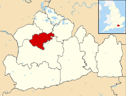
Goldsworth Park is a parish of the Church of England created to serve the Goldsworth Park estate which has diverse housing, parks, gardens and roads laid out on a sparsely populated greenfield area. The parish page on the church's web site states that Goldsworth Park was designed as a “garden estate”.

The parish is bounded by St John's and Woking to the south, and by Knaphill and Horsell to the west and north-east.

Parish history

From the Domesday Book of 1086 [2] (and possibly earlier) until 1884, Goldsworth Park was part of the parish of Woking, which in 1848 "comprise[d] 10,000 acres [40 square kilometres (15 sq mi)] by computation". [3] St John the Baptist Church, 'Goldsworth' built of stone in 13th-century style, was designed by George Gilbert Scott in 1842 (later knighted), and enlarged in 1879 and 1883, and in the year after what was considered St John's, Goldsworth gained the status of a parish. [4]

In the 20th century the area around that church became widely known as St Johns and the large north-western portion of its area which broke off in 1988 to be the parish of the new church took up a variant of the old name of the district, chosen by the area's developers. [5]

See also

P christianity.svg   Christianityportal

Related Research Articles

Chobham Human settlement in England

Chobham is a village and civil parish in the Borough of Surrey Heath in Surrey, England.

Horsell Human settlement in England

Horsell is a village in the borough of Woking in Surrey, England, less than a mile north-west of Woking town centre. In November 2012, its population was 9,384. Horsell is integral to H. G. Wells' classic science fiction novel The War of the Worlds, the sand pits of Horsell Common being the site of the first Martian landing. Horsell Common has since been designated a Site of Special Scientific Interest. Another landmark is the McLaren Technology Centre, built on the northern edge of the common in the early 2000s for the McLaren Group.

Roman Catholic Diocese of Arundel and Brighton

The Roman Catholic Diocese of Arundel and Brighton is a Latin Church Roman Catholic diocese in southern England covering the counties of Sussex and Surrey. The diocese was erected on 28 May 1965 by Pope Paul VI, having previously been a part of the larger Diocese of Southwark, which was elevated to an archdiocese with a new ecclesiastical province on the same date.

Brookwood, Surrey Human settlement in England

Brookwood is a village in Surrey, England, about 3+12 miles (5.6 km) west of Woking, with a mixture of semi-rural, woodland-set and archetypal suburban residential homes. It lies on the western border of the Woking Borough, with a small part of the village in Guildford Borough. As part of the 2016 boundary review Brookwood became part of the Heathlands ward which comprises Brookwood, Bridley, Hook Heath, Mayford, Sutton Green and Barnsbury and Wych Hill.

Goldsworth Park Human settlement in England

Goldsworth Park is a large housing estate to the north-west of Woking in Surrey, England. It was named after the nearby Goldsworth area which was a large 'tithing' of Woking Parish. The tithing included most of the north west of Woking, such as Brookwood, Knaphill and St. John's. It is bordered by villages such as St. John's, Knaphill and Horsell.

Diocese of Guildford Diocese of the Church of England

The Diocese of Guildford is a Church of England diocese covering eight and half of the eleven districts in Surrey, much of north-east Hampshire and a parish in Greater London. The cathedral is Guildford Cathedral and the bishop is the Bishop of Guildford. Of the two provinces of the church, it is in the Province of Canterbury.

History of Woking

Woking means"(settlement belonging to the) followers of Wocc ". Over time, the name has been written variously as, for example, Wochingas, and Wokynge.

Worplesdon Village in England

Worplesdon is a village 3.1 miles (5.0 km) NNW of Guildford in Surrey, England and a large dispersed civil parish that includes the settlements of: Worplesdon itself, Fairlands, Jacobs Well, Rydeshill and Wood Street Village, all various-sized smaller settlements, well-connected by footpaths and local roads. Its area includes Whitmoor Common, which can be a collective term for all of its commons.

The River Bourne is the name given to a Thames tributary in northwest Surrey, England which has a longer tributary, the Windle Brook, that rises nears Bagshot Park in the south of Swinley Forest, Berkshire, merging with it while flowing through villages north of Woking; downstream the Bourne joins the Thames near Weybridge.

Fairlands Hamlet in England

Fairlands is the largest settlement (neighbourhood) of Worplesdon, a village with a civil parish council in the Borough of Guildford, Surrey, England. The neighbourhood is centred 2.6 miles (4.2 km) north-west of Guildford, to which it is linked by a relatively straight road. The arbitrary centre of Worplesdon, a linear settlement, its church, is 1.2 miles (1.9 km) north-east.

St Johns, Woking Human settlement in England

St Johns and Hook Heath is a suburban ward in Surrey consisting of two settlements founded in the 19th century in the medieval parish of Woking. The two 'villages' have residents' associations and are centred 2.5 km WSW and SW of Woking's town centre in the northwest of the English county – by including such suburbs, Woking is the largest town in the county. The ward in 2011 contained 1,888 homes across its 3.46 square kilometres (1.34 sq mi).

Woking Town in England

Woking is a town in northwest Surrey, England. It is at the southwestern edge of the Greater London Urban Area and is a part of the London commuter belt, with frequent trains and a journey time of approximately 24 minutes to Waterloo station. Woking is 23 miles (37 km) southwest of Charing Cross in central London. Woking town itself, excluding its narrowly contiguous built-up area which extends from West End to West Byfleet, has a population of 62,796, and the UK Government has recorded its Built Up Area as 5% more populous than its borough with 105,367 residents in 2011, the highest in the county.

Westfield, Woking, Surrey Human settlement in England

Westfield is an area in Woking Borough, Surrey. Westfield marks the southern boundary of Woking altering from English archetypal suburban homes in the north to semi-rural homes, smallholdings, small woodlands and fields in the south, where it abuts areas of London's Metropolitan Green Belt.

Sutton Green, Surrey Human settlement in England

Sutton Green is a semi-rural suburban settlement and area of Metropolitan Green Belt between Guildford and Woking, Surrey. Sutton Green neighbours Jacobs Well in the Borough of Guildford.

St Dunstans Church, Woking Church in Surrey, United Kingdom

St Dunstan's Church is a Roman Catholic Parish church in Woking, Surrey. At first it was built in 1899, replaced by a larger church in 1923 and its final form was built in 2008. The church was dedicated that year by the Bishop of Arundel and Brighton and Cardinal Cormac Murphy-O'Connor. It is set back in its own plot from Shaftesbury and Pembroke Roads within a mile of the town's centre. It is the only Catholic church in the town and is the centre of the deanery of Woking in the Diocese of Arundel and Brighton.

The 2016 Woking Borough Council election took place on 5 May 2016 to elect members of Woking Borough Council in England. This was on the same day as other elections across the UK and the Police and Crime Commissioner election for Surrey Police.

References

  1. Goldsworth Park St Andrew The Church of England. Retrieved 2014-01-05
  2. Woking The Domesday Book. Domesdaymap.co.uk. Retrieved 2014-01-01
  3. Samuel Lewis, ed. (1848). "Wiveliscombe - Wolford, Little". A Topographical Dictionary of England. Institute of Historical Research. Retrieved 5 January 2014.
  4. H.E. Malden, ed. (1911). "Parishes: Woking". A History of the County of Surrey: Volume 3. Institute of Historical Research. Retrieved 5 January 2014.
  5. Map published by the Church of England Retrieved 2014-01-05