Arncliffe is a small village and civil parish in Littondale, one of the Yorkshire Dales in England. Littondale is a small valley beside Upper Wharfedale, 3 miles (4.8 km) beyond Kilnsey and its famous crag. It is part of the Craven district of the non-metropolitan county of North Yorkshire, but is in the historic West Riding of Yorkshire. The population of the civil parish was estimated at 80 in 2015.

Birkby is a village and civil parish about 6 miles north of the county town of Northallerton in the Hambleton district of North Yorkshire, England. The population of the parish was estimated at 40 in 2016.

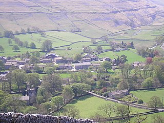
Litton is a village and civil parish in Littondale in the Yorkshire Dales in England. It lies in the Craven District of North Yorkshire, 1.5 miles (2.4 km) up Littondale from Arncliffe. From Litton a footpath leads 3 miles (4.8 km) over the fells to the north east to Buckden in Wharfedale. The population of the civil parish was estimated at 70 in 2015.

Downholme is a village and civil parish in North Yorkshire, England. It is situated approximately 4 miles (6 km) west from the market town of Richmond and 16 miles (26 km) west from the county town of Northallerton. The village lies close to the edge of the Yorkshire Dales. The population as taken in the ONS Census of 2011 was less than 100, so details are included in the parish of Hudswell. In 2015, North Yorkshire County Council estimated the population of the village to be 50.

Holme is a small village and civil parish in the Hambleton District of North Yorkshire, England. It is located near Pickhill, Sinderby and Ainderby Quernhow, on the west bank of the River Swale. The population of the civil parish was estimated at 60 in 2014.

West Scrafton is a village and civil parish in Coverdale in the Yorkshire Dales, England. It is located 4 miles (6.4 km) south west of Leyburn. It falls within the Richmondshire district of North Yorkshire. The population was estimated at 70 in 2013.

High Ellington is a village in lower Wensleydale in North Yorkshire, England, about 2.5 miles (4 km) north-west of Masham. The smaller village of Low Ellington is 0.6 miles (0.97 km) to the east. High Ellington is in Harrogate district, and is the largest settlement in the civil parish of Ellington High and Low, which also includes Low Ellington and the scattered settlement of Sutton. The population of the parish was estimated at 60 in 2013.

Wath is a village and civil parish 3.7 miles (6 km) north of Ripon in North Yorkshire, England. The population of the parish was estimated at 210 in 2015.

Fearby is a village and civil parish in North Yorkshire, England. It is located in the valley of the River Burn 2 miles (3 km) west of Masham. Nearby settlements include Healey, High Ellington and Swinton. The population of the parish was estimated at 130 in 2013.

Healey is a small village and civil parish in the Harrogate district of North Yorkshire, England. It is situated in the valley of the River Burn, to the immediate west of Fearby. It is about three miles west of Masham in the Nidderdale Area of Outstanding Natural Beauty. There are several holiday cottages and four Grade II Listed buildings, one of which is Healey Mill, a former corn mill.
Howe is a small village and civil parish in the Hambleton District of North Yorkshire, England. It is situated near Ainderby Quernhow and the A61 and 5 miles (8 km) west of Thirsk. The population of the civil parish was estimated at 20 in 2015.

Colsterdale is the valley of the River Burn, a tributary of the River Ure, in the Yorkshire Dales in North Yorkshire, England. It gives its name to a hamlet and civil parish in the upper part of the dale, about 7 miles (11 km) west of Masham. The population of the civil parish was estimated at 20 in 2010. The lower part of the dale around the hamlet of Gollinglith Foot is in the civil parish of Healey. The area is in Harrogate district.

Tosside is a small village on the modern border of North Yorkshire and Lancashire in Northern England. It lies within the Forest of Bowland, and is between the villages of Slaidburn in Lancashire and Wigglesworth in North Yorkshire. It lies 11.5 miles north of Clitheroe and 17 miles north-west of Skipton. The village is 870 feet (270 m) above sea level and lies at 54.0001°N / 2.35436°W on the B6478 road.

Staintondale is a small village and civil parish in the Scarborough district of North Yorkshire, England. The village is situated 7 miles (11 km) north west of Scarborough town centre. The parish also includes the village of Ravenscar, 2 miles (3 km) north of the village of Staintondale, and the whole parish lies within the North York Moors National Park.

Sutton Howgrave is a village in North Yorkshire, England. It is the only village in the civil parish of Sutton with Howgrave. The population of the parish was estimated at 70 in 2014.
Ilton is a village in North Yorkshire, England, 3 miles south-west of Masham. It is the principal settlement in the civil parish of Ilton cum Pott, in Harrogate district. The parish includes Roundhill Reservoir. The population of the parish was estimated at 50 in 2015.

East Tanfield is a civil parish in North Yorkshire, England. There is no modern village in the parish, and the population was estimated at 30 in 2013. The deserted medieval village of East Tanfield lies near Manor Farm on the banks of the River Ure.

Grantley is a village and civil parish in North Yorkshire, England. It lies 5 miles (8 km) west of Ripon. The parish also includes the hamlet of Low Grantley. The population of the parish was estimated at 130 in 2013.
Ellerton Abbey is a civil parish in the Richmondshire district of North Yorkshire, England. It is located on the River Swale in lower Swaledale, 6 miles (10 km) south-west of Richmond. The population of the parish was estimated at 20 in 2016. The parish consists of farmland, a few scattered houses and an area of moorland which is part of the army training area associated with Wathgill Camp. The parish includes the site of the deserted medieval village of Ellerton, not to be confused with the modern village of Ellerton-on-Swale 11 miles to the east, but there is no modern village in the civil parish.

Walburn is a hamlet and civil parish in North Yorkshire, England. It is located in lower Swaledale, 5 miles (8 km) south-west of Richmond. The population of the parish was estimated at 10 in 2016.

