Irvine is a hamlet in Alberta, Canada within Cypress County. It is located approximately 35 kilometres (22 mi) east of Medicine Hat on Highway 1 and has an elevation of 763 metres (2,503 ft). The hamlet is located in census division No. 1 and in the federal riding of Medicine Hat.

New Sarepta is a hamlet in central Alberta, Canada, within Leduc County. It is located approximately 23 km (14 mi) east of the City of Leduc along Highway 21.
Willingdon is a hamlet in central Alberta, Canada within the County of Two Hills No. 21. It is located approximately 117 km (73 mi) northeast of Edmonton, Alberta's capital city.

Endiang is a hamlet in Alberta, Canada within the County of Stettler No. 6. It is located approximately 80 kilometres (50 mi) southeast of Stettler.
Schuler is a hamlet in southern Alberta, Canada within Cypress County, located 4 kilometres (2.5 mi) east of Highway 41, approximately 40 kilometres (25 mi) northeast of Medicine Hat.

The County of Warner No. 5 is a municipal district in southern Alberta, Canada. Located in Census Division No. 2 just north of the United States border, its municipal office is located in the Village of Warner.
Cheadle is a hamlet in Alberta, Canada within Wheatland County. It is located on Highway 24, 2 kilometers (1.2 mi) south of the Highway 1 and approximately 35 kilometers (22 mi) east of the City of Calgary.
Clairmont is a hamlet in northern Alberta, Canada within the County of Grande Prairie No. 1. Previously an incorporated municipality, Clairmont dissolved from village status on January 1, 1946 to become part of the Municipal District of Bear Lake No. 740.
Enchant is a hamlet in southern Alberta, Canada within the Municipal District of Taber. It is on Highway 526 and the Canadian Pacific Kansas City railway, between Vauxhall and Lomond. It has an elevation of 810 metres (2,660 ft).
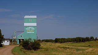
Kirriemuir is hamlet in east-central Alberta, Canada within Special Area No. 4. It is located on Highway 12, approximately 12 kilometres (7.5 mi) west of Altario. It has an elevation of 730 metres (2,400 ft).

Brant is a hamlet in southern Alberta, Canada within Vulcan County. It is located 6 kilometres (3.7 mi) south of Highway 23, approximately 71 kilometres (44 mi) southeast of Calgary. It is named after the number of Brant in the area. Brant is home to a grain elevator and a Christian School.
Metiskow is a hamlet in central Alberta, Canada, within the Municipal District of Provost No. 52. It is located 2 kilometres (1.2 mi) southwest of Highway 13, approximately 105 kilometres (65 mi) southwest of Lloydminster. The name is derived from metosi-skaw.
Spring Coulee is a hamlet in southern Alberta, Canada within Cardston County, located 2 kilometres (1.2 mi) east of Highway 5, approximately 42 kilometres (26 mi) southwest of Lethbridge.
Travers is a hamlet in southern Alberta, Canada within Vulcan County. It is located approximately 59 kilometres (37 mi) southwest of Highway 1 and 59 kilometres (37 mi) southwest of Brooks.

Watino is a hamlet in northern Alberta, Canada within Birch Hills County. It is located on Highway 49, approximately 96 kilometres (60 mi) northeast of Grande Prairie, and has an elevation of 385 meters (1,263 ft).
Carolside is a hamlet and ghost town located in Special Area No. 2 in Alberta, Canada. Carolside was established in 1919 when the Canadian National Railway was constructed in the area. The hamlet was planned to have a grocery store, grain elevators, a trains station, a hardware store, a feed mill, and a manufacturing plant. By the 1950s, the new settlement was abandoned, having suffered serious blows caused by the Wall Street Crash of 1929 and the Great Depression. The railway line through the settlement was closed in the 1970s. There are no longer any buildings or structures left in Carolside, and that remains is the concrete foundation of the grain elevator and the faint remnants of the hamlets streets. In between Carolside and the hamlet of Sunnynook there is the Carolside Reservoir and Campground, named after the hamlet, which was the site of the discovery of Mosasaur remains in the 2010s. To commemorate this discovery, there is a sculpture of the Mosasaur at the reservoir.
Benton, also known as Benton Station, is a hamlet located in Special Area No. 3 in Alberta, Canada. It is approximately 9 km (5.6 mi) east of the town of Oyen and approximately 24.5 km (15.2 mi) west of the border with Saskatchewan. The name originates from Fort Benton named after Thomas Hart Benton. The hamlet at one point had a post office and a CNR station.
Excel is a hamlet located in Special Area No. 3 in Alberta, Canada. It was named by early settlers in 1911 as a description of its general location.
Lanfine is a hamlet located in Special Area No. 3 in Alberta, Canada. It is named after the Lanfine House in Ayrshire, Scotland near the home of the first postmaster.
Loyalist is a hamlet located in Special Area No. 4 in Alberta, Canada. It is located approximately 11.4 km (7.1 mi) east of the village of Veteran and 12.5 km (7.8 mi) west of the village of Consort. Following the Coronation of George V and Mary in 1911, many places along the Canadian National Railway were given patriotic and royal-themed names, including Coronation, Veteran, Consort, Throne, and Loyalist.

