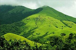
Madikeri is a hill station town in Madikeri taluk and headquarters of Kodagu district in Karnataka, India. Its original name was Muddurajanakeri which means "the city of Mudduraja".

Udupi district is an administrative subdivision in the Karnataka state of India, with the district headquarters in the city of Udupi. It is situated in the Canara old north Malabar coastal region. There are seven taluks, 233 villages and 21 towns in Udupi district. The three northern tehsils of Udupi, Kundapur and Karkala, were partitioned from Dakshina Kannada district to form Udupi district on 25 August 1997. Moodabidri was officially declared as new tehsil (taluk), separated from Karkala with effect from 11 January 2018.

Kollur is a village in the southern state of Karnataka, India. It is located in the Byndoor taluk of Udupi district in Karnataka.
The town of Virajpet also spelled as Virajapete is town of the district of Kodagu, in India's southern State of Karnataka. It is the main town of the Virajpet taluka, south of the district, and borders Kerala State. The name of the town is derived from its founder, Dodda Vira Rajendra.

Somwarpet is a panchayat town in Kodagu district in the Indian state of Karnataka. It is the main town of the Somwarpet taluk, in the north-east of the district. 2nd highest Administrative town in Karnataka in terms of elevation. The main crops grown in the area are coffee and spice crops such as cardamom, peppers, oranges, ginger and vegetables.

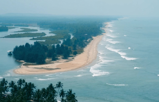
Maravanthe is a village and a beach in Byndoor Taluk, Udupi District, Karnataka, India.

Bhagamandala is a pilgrimage place in Kodagu district of the Indian state of Karnataka.
Shiroor is a village in Byndoor Taluk in the state of Karnataka, India. Mudramakki, Tuddalli, Kotemane, Hadavinakone and Neerugadde are localities within Shiroor. It is home to the Kannada, Konkani.Zamaithi & Nakhuda are languages commonly spoken in the area. Hindus are in majority.

The Irupu Falls are located in the Brahmagiri Range in the Kodagu district of Karnataka, India, bordering the Wayanad district of Kerala. It is a fresh water cascade and is situated at a distance of 48 km from Virajpet on the highway to Nagarhole. The falls are also known as the Lakshmana Tirtha Falls, derived from the name of the tributary of Cauvery which starts from these falls, the Lakshmana Tirtha River.
Bijoor is a Village near to Byndoor in the southern state of Karnataka, India. It is located in the Byndoor taluk of Udupi district in Karnataka.Bijur Gram Panchayat consists of a single village consisting of 4 broad wards. The village is bounded by the town of Byndoor to the north, Kergalu to the south, Kaltodu to the east and Uppunda village to the west. Bijoor village is located in 6 km from the taluk center and Hobali. The village has one high school, four higher primary schools and one private Shri Vivekananda English Medium School that provides high-quality education.
Uppunda is a large village in Byndoor Taluk with west coast of the village on the Arabian Sea in South India. The nearest city with an airport is Mangalore which is about 119 kilo-meters away. The town is reachable by water and road from Mangalore. Nearest railway station Byndoor Mookambika Road(BYNR) railway station. It is located in the Byndoor taluk of Udupi district in Karnataka.

Virajpet Assembly constituency is one of the 224 Karnataka Legislative Assembly constituencies of Karnataka. It is represented in the Karnataka Legislative Assembly by A. S. Ponnanna of the Indian National Congress.

Byndoor is a coastal town and headquarters of Byndoor Taluk in the Udupi District of Karnataka state, India. It is about 450 kilometres (280 mi) from the state capital Bengaluru and 60 kilometres (37 mi) from the Udupi district headquarters. It has an area of 67.0536 square kilometres (25.8895 sq mi) and a population of 24,957 in 2011. It lies in the foothills of Western Ghats on one side and a virgin Someshwar Beach on the other side. The Mookambika Road Byndoor railway station focuses on the pilgrims visiting the Kollur Mookambika Temple which is 28 km from Byndoor. Near by another railway station name is Bijoor, As many as 26 villages including Shiroor, Paduvari, Yadthare, Taggarse, Uppunda, Nandanavana, Kergalu, (Naikanakatte) Bijoor, Kirimanjeshwar, Ullur, Khambadakone, Heranjalu, Navunda, Badakere, Maravanthe, Hadavu, Naada, herur, Kalthodu, Golihole, Yalajith, Kollur, Jadkal, Mudoor, and Hallihole have been brought together under the Byndoor taluk.
Pumpwell Mangalore, Karnataka, India. Pumpwell Junction is one of the busiest junctions in Mangalore. Pumpwell is just 3 kilometres (1.9 mi) away from Hampankatta a major commercial centre, 3 km from Mangalore Central railway station, 2.3 km from Mangalore Junction railway station. Karnataka bank, one of the major public sector banks of India is having head office at Pumpwell. It plays a significant role in city transport due to the fact that number of important roads including NH-66, Virajpet-Byndoor road passes through this location. Mangalore - Bangalore highway NH-75, connecting two big cities of Karnataka originates here. This is also the place where there is a proposal to build new bus stand under public-private-partnership (PPP) mode.

Mookambika Road Byndoor is a railway station in coastal Karnataka in South of India. Its four-letter code is BYNR. Mookambika Road Byndoor is the main railway station in the town of Byndoor in Udupi district. It serves Byndoor city which is 1 kilometre away from the station. It is the nearest railway station to the famous pilgrimage centre, Kollur Mookambika temple. The distance from Byndoor railway station to Kollur Mookambika temple is about 28 km which can be covered in 40 minutes to one hour by road. Trains from here connect the city to prominent state capitals of India like Bangalore (Karnataka), Thiruvananthapuram, Mumbai and so forth. It is also well connected to the major railway stations such as Goa (Madgoan), Udupi, Mangalore, Kasaragod and Ernakulam. Rail connectivity in Byndoor was established in 1997. A total of 34 express and passenger trains halt here; there was one originating and terminating trains at this station: Mookambika Road–Kannur Passenger train; however this service was terminated in 2017 within two years of service due to lack of revenue generation. Although the railway station caters to a lot of passengers and superfast trains on a daily basis, it does not have a siding line or passing loop. Any crossing of trains can only happen either on Bijoor or Shiroor railway stations 19 km apart.
National Highway 766C, commonly referred to as NH 766C is a national highway in India. It is a spur road of National Highway 66. NH-766C traverses the state of Karnataka in India.

Byndoor Assembly constituency is one of the 224 Legislative Assembly constituencies of Karnataka state in India.
State Highway 90 also known as SH-90 is a state highway connecting Hunsur of Mysore and Talakaveri of Kodagu district, in the South Indian state of Karnataka. It has a total length of 122.45 kilometres (76.09 mi).
State Highway 91 (SH-91) is a state highway connecting Konanur village of Hassan district and Makutta village of Kodagu, in the South Indian state of Karnataka. It has a total length of 95.50 kilometres (59.34 mi).
Kodlipete or Kodlipet is a village in Somwarpet taluk in Kodagu district of Karnataka, India. It is the northernmost town of Kodagu district.


