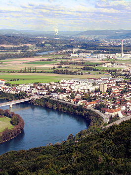
Hydroelectric power plant that crosses the Rhine from Bad Säckingen (Germany) and Stein (Switzerland)Aerial view (1949)
Stein has an area, as of 2009[update], of 2.81 square kilometers (1.08sqmi). Of this area, 0.8km2 (0.31sqmi) or 28.5% is used for agricultural purposes, while 0.62km2 (0.24sqmi) or 22.1% is forested. Of the rest of the land, 1.1km2 (0.42sqmi) or 39.1% is settled (buildings or roads), 0.29km2 (0.11sqmi) or 10.3% is either rivers or lakes.[3]
Of the built up area, industrial buildings comprise approximately 8.9% of the total area; housing and buildings account for 13.9% transportation infrastructure, 13.5%, parks, with green belts and sports fields making up 2.1%. Out of the forested land, 19.9% of the total land area is heavily forested and 2.1% is covered with orchards or small clusters of trees. Of the agricultural land, 19.9% is used for growing crops and 7.1% is pastures, while 1.4% is used for orchards or vine crops. All the water in the municipality is in rivers and streams.[3]
Coat of arms
The blazon of the municipal coat of arms is Gules a Fiddle Argent bendwise with neck downwards.[4]
Demographics
Stein has a population (as of December 2020[update]) of 3,253.[5]As of June2009[update], 33.6% of whom are foreign nationals.[6] Over the last 10years (1997–2007) the population has changed at a rate of 18.7%. Most of the population (as of 2000[update]) speaks German (86.6%), with Italian being second most common ( 3.6%) and Albanian being third ( 3.0%).[7]
The age distribution, as of 2008[update], in Stein is; 248 children or 8.8% of the population are between 0 and 9years old and 317 teenagers or 11.2% are between 10 and 19. Of the adult population, 407 people or 14.4% of the population are between 20 and 29years old. 404 people or 14.3% are between 30 and 39, 513 people or 18.2% are between 40 and 49, and 400 people or 14.2% are between 50 and 59. The senior population distribution is 264 people or 9.3% of the population are between 60 and 69years old, 168 people or 5.9% are between 70 and 79, there are 94 people or 3.3% who are between 80 and 89, and there are 10 people or 0.4% who are 90 and older.[8]
As of 2000[update] the average number of residents per living room was 0.58, approximately the same as the cantonal average of 0.57 per room. In this case, a room is defined as space of a housing unit of at least 4m2 (43sqft) as normal bedrooms, dining rooms, living rooms, kitchens and habitable cellars and attics.[9] About 38.7% of the total households were owner occupied, or in other words did not pay rent (though they may have a mortgage or a rent-to-own agreement).[10]
As of 2000[update], there were 104 homes with 1 or 2 persons in the household, 657 homes with 3 or 4 persons in the household, and 255 homes with 5 or more persons in the household.[11]As of 2000[update], there were 1,037 private households (homes and apartments) in the municipality, and an average of 2.3 persons per household.[7]In 2008[update] there were 330 single family homes (or 26.7% of the total) out of a total of 1,235 homes and apartments.[12] There were a total of 7 empty apartments for a 0.6% vacancy rate.[12]As of 2007[update], the construction rate of new housing units was 17.6 new units per 1000 residents.[7]
In the 2007 federal election the most popular party was the SVP which received 34.45% of the vote. The next three most popular parties were the SP (17.79%), the FDP (17.11%) and the CVP (16.91%). In the federal election, a total of 600 votes were cast, with a voter turnout of 37.8%.[13]
The historical population is given in the following table:[8]
Historical population
Year
Pop.
±%
1975
1,777
—
1980
1,781
+0.2%
1990
1,926
+8.1%
2000
2,375
+23.3%
Heritage sites of national significance
Wooden bridge between Bad Säckingen (Germany) and Stein (Switzerland)
As of 2007[update], Stein's unemployment rate was 3.77%. As of 2005[update], there were 11 people employed in the primary economic sector and about 5 businesses involved in this sector. 1,611 people are employed in the secondary sector which features 22 businesses. 597 people are employed in the tertiary sector, with 89 businesses in this sector.[7]
In 2000[update] there were 1,251 workers who lived in the municipality. Of these, 855 or about 68.3% of the residents worked outside Stein while 1,446 people commuted into the municipality for work. There were a total of 1,842 jobs (of at least 6hours per week) in the municipality.[15] Of the working population, 18.6% used public transportation to get to work, and 46.2% used a private car.[7]
Religion
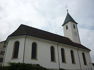
Roman Catholic church in Stein
From the 2000 census[update], 1,100 or 45.6% were Roman Catholic, while 688 or 28.5% belonged to the Swiss Reformed Church. Of the rest of the population, there were around 30 individuals (or about 1.24% of the population) who belonged to the Christian Catholic faith.[11]
Education
The entire Swiss population is generally well-educated. In Stein about 65.4% of the population (between age 25–64) have completed either non-mandatory upper secondary education or additional higher education (either university or a Fachhochschule).[7] Of the school age population (in the 2008/2009 school year[update]), there are 200 students attending primary school, there are 81 students attending secondary school in the municipality.[11]
Related Research Articles
Leibstadt is a municipality in the district of Zurzach in the canton of Aargau in Switzerland.
Laufenburg is a municipality in the Swiss canton of Aargau. It is the seat of the district of the same name. On 1 January 2010 the municipality Sulz merged into Laufenburg.
Strengelbach is a municipality in the district of Zofingen in the canton of Aargau in Switzerland.
Wiliberg is a municipality in the district of Zofingen in the canton of Aargau in Switzerland.
Sarmenstorf is a municipality in the district of Bremgarten in the canton of Aargau in Switzerland.
Mandach is a municipality in the district of Brugg in canton of Aargau in Switzerland.
Veltheim is a municipality in the district of Brugg in the canton of Aargau in Switzerland.
Villigen is a municipality in the district of Brugg in the canton of Aargau in Switzerland. In January 2006, Villigen incorporated the former municipality of Stilli.
Gansingen is a municipality in the district of Laufenburg in the canton of Aargau in Switzerland.
Hornussen is a former municipality in the district of Laufenburg in the canton of Aargau in Switzerland. On 1 January 2022 the former municipalities of Bözen, Effingen, Elfingen and Hornussen merged into the new municipality of Böztal.
Münchwilen is a municipality in the district of Laufenburg in the canton of Aargau in Switzerland.
Kaisten is a municipality in the district of Laufenburg in the canton of Aargau in Switzerland. On 1 January 2010 the municipality of Ittenthal merged into the municipality of Kaisten.
Zeihen is a municipality in the district of Laufenburg in the canton of Aargau in Switzerland.
Mumpf is a municipality in the district of Rheinfelden in the canton of Aargau in Switzerland.
Schupfart is a municipality in the district of Rheinfelden in the canton of Aargau in Switzerland.
Wallbach is a municipality in the district of Rheinfelden in the canton of Aargau in Switzerland.
Obermumpf is a municipality in the district of Rheinfelden in the canton of Aargau in Switzerland.
Hallwil is a municipality in the district of Lenzburg in the canton of Aargau in Switzerland.
Hendschiken is a municipality in the district of Lenzburg in the canton of Aargau in Switzerland.
Wislikofen is a village and former municipality in the district of Zurzach in the canton of Aargau in Switzerland. On 1 January 2022 the former municipalities of Bad Zurzach, Baldingen, Böbikon, Kaiserstuhl, Rekingen, Rietheim, Rümikon and Wislikofen merged into the new municipality of Zurzach.
This page is based on this Wikipedia article Text is available under the CC BY-SA 4.0 license; additional terms may apply. Images, videos and audio are available under their respective licenses.