Stratford Town Hall

Last updated

Stratford Town Hall
HE1080991 Old Town Hall Stratford (1).jpg
Stratford Town Hall
LocationBroadway, Stratford
Coordinates 51°32′26″N0°00′07″E / 51.5405°N 0.0019°E / 51.5405; 0.0019 Coordinates: 51°32′26″N0°00′07″E / 51.5405°N 0.0019°E / 51.5405; 0.0019
Built1869
Architect John Giles and Lewis Angell
Architectural style(s) Italianate style
Listed Building – Grade II
Designated6 November 1974
Reference no.1080991
Newham London UK location map.svg
Red pog.svg
Shown in Newham

Stratford Town Hall is a municipal building in Stratford, London. It is a Grade II listed building. [1]

History

In the mid-19th century the West Ham Local Board of Health had met at Rokeby House in Broadway. [2] [3] Following a rapid growth in the local population caused by industrial expansion, [4] civic leaders decided to procure purpose-built council offices: the site chosen for the new building was a plot of open land on the corner of Broadway and West Ham Lane. [5]

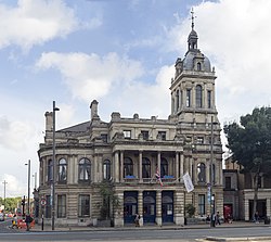
The new building, which was designed by Lewis Angell and John Giles in the Italianate style was completed in 1869. [1] The design involved an asymmetrical main frontage with eleven bays facing onto Broadway; the central section of three bays featured a full-height portico with rounded-headed doorways flanked by Doric order banded columns on the ground floor and round-headed windows flanked by Corinthian order columns on the first floor. [1] The left hand section curved round into West Ham Lane and the right handed section involved a square tower with a cupola and weather vane which was 30.5 metres (100 ft) high. [6] The principal rooms included a council chamber and an assembly hall which was elaborately decorated by the French designer, Mons Boekbinder. [2] [7] The design of the building was described by the Illustrated London News , in 1869, as the "finest building in Essex" [8] and by Pevsner, in 1973, as a "debased arched cinquecento". [9]

The foundation stone for an extension along West Ham Lane was laid by the chairman of the local board, George Rivett, in 1885; the extension, which was also designed by Lewis Angell, was intended to accommodate a courthouse and cells. [6] The building became the headquarters of the new Municipal Borough of West Ham in 1886 [10] [11] and, after becoming the centre of administration for the County Borough of West Ham in 1889, [2] it became the home of the first Labour Party municipal administration in 1898. [4]

The town hall continued to be the home of the county borough for much of the 20th century but ceased to be the local seat of government after the formation of the London Borough of Newham in April 1965. [12] It continued to serve as an events and concert venue and performers included the band, The Who , in May 1965. [13] It also served as offices for the education department of Newham council until a major fire broke out causing considerable damage on 26 June 1982. [2] It was restored to the designs of the borough architect, Kenneth Lund, and was re-opened by Queen Elizabeth II as a conference centre on 16 July 1986. [14]

Related Research Articles

<span class="mw-page-title-main">Chingford</span> Human settlement in England

Chingford is a town in east London, England, within the London Borough of Waltham Forest. The centre of Chingford is 9.2 miles (14.8 km) north-east of Charing Cross, with Waltham Abbey to the north, Woodford Green and Buckhurst Hill to the east, Walthamstow to the south, and Edmonton and Enfield to the west. The town contains the areas of Chingford Green, Chingford Hatch, Chingford Mount, Friday Hill, Hale End, Highams Park, and South Chingford, and had a population of 70,583 at the 2021 census.

<span class="mw-page-title-main">Stratford, London</span> Human settlement in England

Stratford is a town in east London, England, within the ceremonial county of Greater London. Until 1965 it was within the historic county of Essex. Part of the Lower Lea Valley, Stratford is situated 6 miles (9.7 km) east-northeast of Charing Cross, and includes the localities of Maryland and East Village.

<span class="mw-page-title-main">West Ham</span> District in East London, England

West Ham is an area in East London, located 6.1 mi (9.8 km) east of Charing Cross in the west of the modern London Borough of Newham.

<span class="mw-page-title-main">London Borough of Newham</span> Inner Borough of London, England

The London Borough of Newham is a London borough created in 1965 by the London Government Act 1963. It covers an area previously administered by the Essex county boroughs of West Ham and East Ham, authorities that were both abolished by the same act. The name Newham reflects its creation and combines the compass points of the old borough names. Situated in the Inner London part of East London, Newham has a population of 387,576, which is the third highest of the London boroughs and also makes it the 16th most populous district in England. The local authority is Newham London Borough Council.

<span class="mw-page-title-main">Plaistow, Newham</span> Town in East London, England

Plaistow is a suburban area of East London, England, within the London Borough of Newham. It adjoins Upton Park to the north, East Ham to the east, Beckton to the south, Canning Town to the south-west and West Ham to the west.

<span class="mw-page-title-main">East Ham</span> Suburban district of London, England

East Ham is a district of the London Borough of Newham, England, 8 miles (12.8 km) east of Charing Cross. East Ham is identified in the London Plan as a Major Centre. The population is 76,186.

Canning Town is a district in the London Borough of Newham, East London. The district is located to the north of the Royal Victoria Dock, and has been described as the "Child of the Victoria Docks" as the timing and nature of its urbanisation was largely due to the creation of the dock. The area was part of the ancient parish of West Ham, in the hundred of Becontree, and part of the historic county of Essex. It forms part of the London E16 postcode district.

<span class="mw-page-title-main">Beckton</span> Human settlement in England

Beckton is a suburb in east London, England, located 8 miles (12.9 km) east of Charing Cross and part of the London Borough of Newham. Adjacent to the River Thames, the area consisted of unpopulated marshland known as the East Ham Levels in the parishes of Barking, East Ham, West Ham and Woolwich. The development of major industrial infrastructure in the 19th century to support the growing metropolis of London caused an increase in population with housing built in the area for workers of the Beckton Gas Works and Beckton Sewage Treatment Works. The area has a convoluted local government history and has formed part of Greater London since 1965. Between 1981 and 1995 it was within the London Docklands Development Corporation area, which caused the population to increase as new homes were built and the Docklands Light Railway was constructed.

<span class="mw-page-title-main">Forest Gate</span> Human settlement in England

Forest Gate is a district in the London Borough of Newham, East London, England. It is located 7 miles (11 km) northeast of Charing Cross.

<span class="mw-page-title-main">History of Essex</span> Aspect of history

Essex is a county in the East of England which originated as the ancient Kingdom of Essex and one of the seven kingdoms, or heptarchy, that went on to form the Kingdom of England.

<span class="mw-page-title-main">County Borough of East Ham</span>

East Ham was a local government district in the far south west of Essex from 1878 to 1965. It extended from Wanstead Flats in the north to the River Thames in the south and from Green Street in the west to Barking Creek in the east. It was part of the London postal district and Metropolitan Police District.

<span class="mw-page-title-main">County Borough of West Ham</span> Historical local government district in the extreme south west of Essex

West Ham was a local government district in the extreme south west of Essex from 1886 to 1965, forming part of the built-up area of London, although outside the County of London. It was immediately north of the River Thames and east of the River Lea.

<span class="mw-page-title-main">Municipal Borough of Leyton</span>

Leyton was a local government district in southwest Essex, England, from 1873 to 1965. It included the neighbourhoods of Leyton, Leytonstone and Cann Hall. It was suburban to London, forming part of the London postal district and Metropolitan Police District. It now forms the southernmost part of the London Borough of Waltham Forest in Greater London.

<span class="mw-page-title-main">Custom House, Newham</span> Human settlement in England

Custom House is an area in the London Borough of Newham, in East London, England.

<span class="mw-page-title-main">Stratford Langthorne Abbey</span>

Stratford Langthorne Abbey, or the Abbey of St Mary's, Stratford Langthorne was a Cistercian monastery founded in 1135 at Stratford Langthorne — then Essex but now Stratford in the London Borough of Newham. The Abbey, also known as West Ham Abbey as it lay in that parish, was one of the largest Cistercian abbeys in England, possessing 1,500 acres (6.07 km2) of local land, controlling over 20 manors throughout Essex. The Abbey was self-sufficient for its needs and wealthy besides; some of this wealth came from the ecclesiastic mills grinding wheat for local bakers to supply bread to the City of London. This later led to competition with the Guild of Bakers, who sought powers to levy a toll on loaves entering the City at Whitechapel.

<span class="mw-page-title-main">University of East London Stratford Campus</span> College in London Borough of Newham, England

The University of East London Stratford Campus is based in and around University House, a Grade II* listed building, located in Stratford, London in the London Borough of Newham. The nearest station is Maryland.

<span class="mw-page-title-main">105 Barking Road</span> Historic site in Canning Town

105 Barking Road is a former public hall in Canning Town, in the London Borough of Newham, in the United Kingdom. The building is situated in the ward of Canning Town South, on the north of Barking Road, to the northeast of Canning Town station. 105 Barking Road is a classic example of a Victorian town hall with links to East London's suffragette and labour movements during the late nineteenth and early twentieth centuries. The building is a Grade II listed building.

<span class="mw-page-title-main">Newham Town Hall</span> Municipal building in London, England

Newham Town Hall, formerly East Ham Town Hall, is a municipal building in Barking Road, East Ham, London. The town hall, which is the headquarters of Newham London Borough Council, is a Grade II* listed building.

<span class="mw-page-title-main">Chingford Town Hall</span> Municipal building in London, England

Chingford Town Hall is a municipal building in The Ridgeway, Chingford, London. It is a locally listed building.

<span class="mw-page-title-main">Leyton Town Hall</span> Municipal building in London, England

Leyton Town Hall is a municipal building in Adelaide Road, Leyton, London. The building, which includes Leyton Great Hall, is a Grade II listed building.

References

  1. 1 2 3 Historic England. "Education Offices (1080991)". National Heritage List for England . Retrieved 9 May 2020.
  2. 1 2 3 4 "London's Town Halls". Historic England. p. 160. Retrieved 9 May 2020.
  3. Powell, W R (1973). "'West Ham: Domestic buildings', in A History of the County of Essex". London: British History Online. pp. 50–57. Retrieved 9 May 2020.
  4. 1 2 Powell, W R (1973). "'West Ham: Local government and public services', in A History of the County of Essex". London: British History Online. pp. 96–112. Retrieved 9 May 2020.
  5. "Ordnance Survey Map". 1850. Retrieved 9 May 2020.
  6. 1 2 "1869 – Public Office & Vestry Hall, Stratford, London". archiseek.com. 31 March 2013. Retrieved 25 October 2014.
  7. "Stratford Old Town Hall". London Borough of Newham. Retrieved 9 May 2020.
  8. The Illustrated London News. 18 September 1869. p. 272.
  9. Pevsner, Nikolaus (1973). The buildings of England: Essex. Penguin. p. 374. ISBN   978-0140710113.
  10. "No. 25596". The London Gazette . 11 June 1886. pp. 2797–2798.
  11. "The Incorporation Of West Ham". The Times . 23 June 1886. p. 6.
  12. "Local Government Act 1963". Legislation.gov.uk. Retrieved 25 April 2020.
  13. Neill, Andrew; Kent, Matthew (2009). Anyway, Anyhow, Anywhere: The Complete Chronicle of the WHO 1958–1978. Sterling Publishing Company. p. 304. ISBN   978-1402766916.
  14. "The Old Town Hall Stratford". Stratford Renaissance Partnership. Archived from the original on 25 October 2014. Retrieved 25 October 2014.