Washington County is a county located in the U.S. state of Kansas. Its county seat and largest city is Washington. As of the 2020 census, the county population was 5,530. The county was named for George Washington, the 1st president of the United States.

Seward County is a county of the U.S. state of Kansas. Its county seat and largest city is Liberal. As of the 2020 census, the county population was 21,964. The county was formed on March 20, 1873, and named after William Seward, a politician and Secretary of State under Abraham Lincoln and Andrew Johnson.

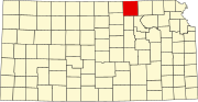
Republic County is a county located in the state of Kansas, south from the Nebraska state line. Its county seat and largest city is Belleville. As of the 2020 census, the county population was 4,674. The county was named after the Republican River.

Pratt County is a county located in the U.S. state of Kansas. Its county seat and largest city is Pratt. As of the 2020 census, the county population was 9,157. The county was named for Caleb Pratt, a U.S. soldier who died in the Battle of Wilson's Creek during the American Civil War and had previously been involved in Bleeding Kansas.

Osborne County is a county located in the U.S. state of Kansas. It county seat and largest city is Osborne. As of the 2020 census, the county population was 3,500. The county is named for Vincent Osborne, a captain in the American Civil War.

Miami County is a county located in east-central Kansas and is part of the Kansas City metropolitan area. Its county seat and most populous city is Paola. As of the 2020 census, the county population was 34,191. The county was named for the Miami tribe.

Hodgeman County is a county located in the U.S. state of Kansas. Its county seat and most populous city is Jetmore. As of the 2020 census, the county population was 1,723. It was named for Amos Hodgman, a member of the 7th Regiment Kansas Volunteer Cavalry.

Harper County is a county located in the U.S. state of Kansas. Its county seat and most populous city is Anthony. As of the 2020 census, the county population was 5,485. The county was named for Sergeant Marion Harper of the 2nd Kansas Cavalry, who died in battle during the American Civil War.

Ellis County is a county located in the U.S. state of Kansas. Its county seat and most populous city is Hays. As of the 2020 census, the county population was 28,934. The county was named for George Ellis, a first lieutenant of the Twelfth Kansas Infantry. Ellis County is the official German Capital of Kansas. German immigrants settled in Hays, Ellis, Victoria, and nearby villages in the 1870s and 1880s.

Decatur County is a county located in Northwest Kansas. Its county seat and most populous city is Oberlin. As of the 2020 census, the county population was 2,764. The county was named in honor of Stephen Decatur, Jr., a commodore in the United States Navy who served during both Barbary Wars in North Africa, the Quasi-War with France, and the War of 1812 with Britain.

Cheyenne County is a county located in the northwest corner of the U.S. state of Kansas. Its county seat and most populous city is St. Francis. As of the 2020 census, the county population was 2,616. The county was named after the Cheyenne tribe.

Carpentersville is a village in Kane County, Illinois, United States. The population was 37,983 at the 2020 census. It is part of the Chicago metropolitan area.

York is a town in Green County, Wisconsin, United States. The population was 910 at the 2010 census. The unincorporated community of Postville is located in the town. The ghost town of Farmers Grove was also located in the town.

Ancaster is a historic town in the city of Hamilton, Ontario, Canada, located on the Niagara Escarpment. Founded as a town in 1793, it immediately developed itself into one of the first significant and influential early British Upper Canada communities established during the late 18th century eventually amalgamating with the city of Hamilton in 2001. By 1823, due to its accessible waterpower and location at the juncture of prehistoric indigenous trading routes, Ancaster had become Upper Canada's largest industrial and commercial centre. Additionally, Ancaster had at that time attracted the 2nd largest populace (1,681) in Upper Canada, trailing only Kingston, but surpassing the populations of nearby Toronto (1,376) and Hamilton (1,000). After this initial period of prosperity in the late 18th century, sudden significant water and rail transportation advancements of the early 19th century would soon better benefit Ancaster's neighbouring towns nearer the Lake Ontario waterfront. Stationary steam engines for industries rapidly developing in the 19th century would eventually make Ancaster's water-powered industries less vital. As a result, after the 1820s, Ancaster's influence would begin to wane during the remainder of the 19th century.

Rootstown Township is one of the eighteen civil townships of Portage County, Ohio, United States. The 2020 census found 8,602 people in the township.

Nicodemus is an unincorporated community in Graham County, Kansas, United States. As of the 2020 census, the population of the community and nearby areas was 14. The community was founded in 1877 and is named for the Biblical figure Nicodemus.

Hamilton is an abandoned mining town located in the White Pine Range, in western White Pine County, Nevada, United States.

Lodi is an unincorporated community in Liberty Township, Parke County, Indiana. Located on Indiana State Road 234, the most prominent feature is Waterman Baptist Church, which occupies a red brick building in the north-east corner of town. Just south of the town is one of the first round barns, the W. H. York Round Barn, which was built in 1895.

Peoria Township is a township in Franklin County, Kansas, USA. As of the 2000 census, its population was 626. Peoria Township has two unincorporated towns: Peoria and Imes.
Sharon Township is one of the twenty townships of Johnson County, Iowa, United States. It is located on the southern county line, about 6 miles (9.7 km) southwest of Iowa City. It is adjacent to Washington, Union and Liberty Townships, as well as Washington County.