
Mount St. Helens is an active stratovolcano located in Skamania County, Washington, in the Pacific Northwest region of the United States. It lies 52 miles (83 km) northeast of Portland, Oregon, and 98 miles (158 km) south of Seattle. Mount St. Helens takes its English name from that of the British diplomat Alleyne Fitzherbert, 1st Baron St Helens, a friend of explorer George Vancouver who surveyed the area in the late 18th century. The volcano is part of the Cascade Volcanic Arc, a segment of the Pacific Ring of Fire.

The Lassen volcanic area presents a geological record of sedimentation and volcanic activity in and around Lassen Volcanic National Park in Northern California, U.S. The park is located in the southernmost part of the Cascade Mountain Range in the Pacific Northwest region of the United States. Pacific Oceanic tectonic plates have plunged below the North American Plate in this part of North America for hundreds of millions of years. Heat and molten rock from these subducting plates has fed scores of volcanoes in California, Oregon, Washington and British Columbia over at least the past 30 million years, including these in the Lassen volcanic areas.

Lassen Peak, commonly referred to as Mount Lassen, is a 10,457 ft (3,187 m) lava dome volcano in Lassen Volcanic National Park in Northern California. Located in the Shasta Cascade region above the northern Sacramento Valley, it is the southernmost active volcano in the Cascade Range of the Western United States, and part of the Cascade Volcanic Arc stretching from southwestern British Columbia to northern California. It supports many flora and fauna among its diverse habitats, which reach high elevations and are subject to frequent snowfall.

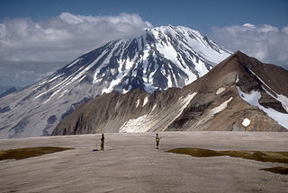
Glacier Peak or Dakobed is the most isolated of the five major stratovolcanoes of the Cascade Volcanic Arc in the U.S state of Washington. Located in the Glacier Peak Wilderness in Mount Baker–Snoqualmie National Forest, the volcano is visible from the west in Seattle, and from the north in the higher areas of eastern suburbs of Vancouver such as Coquitlam, New Westminster and Port Coquitlam. The volcano is the fourth tallest peak in Washington state, and not as much is known about it compared to other volcanoes in the area. Local Native Americans have recognized Glacier Peak and other Washington volcanoes in their histories and stories. When American explorers reached the region, they learned basic information about surrounding landforms, but did not initially understand that Glacier Peak was a volcano. Positioned in Snohomish County, the volcano is only 70 miles (110 km) northeast of downtown Seattle. From locations in northern Seattle and northward, Glacier Peak is closer than the more famous Mount Rainier (Tahoma), but as Glacier Peak is set farther into the Cascades and almost 4,000 feet (1,200 m) shorter, it is much less noticeable than Mount Rainier.

Humphreys Peak is the highest mountain and the second most prominent peak after Mount Graham in the U.S. state of Arizona. With an elevation of 12,633 feet (3,851 m), it is located within the Kachina Peaks Wilderness in the Coconino National Forest, about 11 miles (17.7 km) north of Flagstaff, Arizona. Humphreys Peak is the highest of a group of dormant volcanic peaks known as the San Francisco Peaks.
Mount Griggs, formerly known as Knife Peak Volcano, is a stratovolcano, which lies 10 km behind the volcanic arc defined by other Katmai group volcanoes. Although no historic eruptions have been reported from Mount Griggs, vigorously active fumaroles persist in a summit crater and along the upper southwest flank. The fumaroles on the southwest flank are the hottest, and some of the flank fumaroles can roar so loudly that they can be heard from the valley floor. The slopes of Mount Griggs are heavily mantled by fallout from the 1912 eruption of Novarupta volcano. The summit consists of three concentric craters, the lowest and largest of which contains a recent summit cone topped by two craters. The volume of the volcanic edifice is estimated at 25 cubic kilometers (6.0 cu mi). Isotopic analysis indicates that the source of Griggs' magma is distinct from the other Katmai volcanoes.
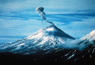
Mount Pavlof or Pavlof Volcano is a stratovolcano of the Aleutian Range on the Alaska Peninsula. It has been one of the most active volcanoes in the United States since 1980, with eruptions recorded in 1980, 1981, 1983, 1986–1988, 1996–1997, 2007, 2013, twice in 2014, 2016, and again in 2021-2022. It is not currently erupting (as of October 15, 2024). The most common lava type here is basaltic andesite and the 2013-2014 lavas contained approximately 53 wt.% SiO2. The volcano is monitored by the Alaska Volcano Observatory- a joint program of the United States Geological Survey (USGS), the Geophysical Institute of the University of Alaska Fairbanks (UAFGI), and the State of Alaska Division of Geological and Geophysical Surveys (ADGGS). With a threat score of 95, the threat from future eruptions is considered to be high; much of this threat comes from the possibility of disruption of nearby air routes by large releases of ash. The mountain shares a name with the nearby Pavlof Sister, which is thought to have last erupted from 1762 to 1786, although this period of activity is sometimes attributed to Pavlof volcano instead.

The Makushin Volcano is an ice-covered stratovolcano located on Unalaska Island in the Aleutian Islands of the U.S. state of Alaska. With an elevation of 2,036 meters (6,680 ft), its summit is the highest point on the island. Makushin is one of the most active among the 52 historically active volcanoes of Alaska. It has erupted at least two dozen times over the past several thousand years, with the last eruption occurring in 1995.

Sugarloaf Mountain is a peak situated in Rio de Janeiro, Brazil, on a peninsula at the mouth of Guanabara Bay. Rising 396 m (1,299 ft) above the harbor, the peak is named for its resemblance to the traditional shape of concentrated refined loaf sugar. It is known worldwide for its cableway and panoramic views of the city and beyond.

Semisopochnoi Island or Unyak Island is part of the Rat Islands group in the western Aleutian Islands of Alaska. The island is uninhabited and provides an important nesting area for maritime birds. The island is of volcanic origin, containing several volcanoes including Mount Young. It has a land area of 85.558 square miles, measuring 11 miles (18 km) in length and 12 miles (20 km) in width.

Sugarloaf Mountain is a ski mountain located in Carrabassett Valley, Franklin County, Maine. It is the third highest peak in the state, after Mount Katahdin's Baxter and Hamlin peaks. Sugarloaf is flanked to the south by Spaulding Mountain.

Sugarloaf Hill is a 785 ft (239 m) peak along the Hudson River in Putnam County, New York, part of the Hudson Highlands. It was named by the Dutch for its resemblance in outline to a sugarloaf when sailing up the river towards it.

Sugarloaf Ridge State Park is a state park in Northern California, United States. Located in the Mayacamas Mountains north of Kenwood, the park straddles the boundary between Sonoma and Napa counties. The park contains the 2,729-foot (832 m) Bald Mountain and the headwaters of Sonoma Creek including a 25-foot (8 m) tall seasonal waterfall. The park is also home to the volunteer-run Robert Ferguson Observatory. Camping, picnicking, horseback riding, mountain biking, stargazing, fishing and hiking are common attractions of Sugarloaf. The park boasts 25 miles of trails with trails ranging from less than a mile to 8.8 miles, and elevation gains reaching 2,500 feet.
Chiricahua Peak is a 9,773 feet (2,979 m) peak located in the Chiricahua Mountains of southeastern Arizona, located about 35 miles (56 km) north of the United States–Mexico border. It is the highest summit in the Chiricahua Mountains and the highest point in Cochise County.

Mount Sugarloaf State Reservation is a state-owned public recreation area managed by the Massachusetts Department of Conservation and Recreation located in South Deerfield, just west of the Connecticut River. The state park includes the summits of North Sugarloaf Mountain and South Sugarloaf Mountain, as well as 1.75 miles of frontage on the Connecticut River and two river islands. The park is part of a larger park designation called the Connecticut River Greenway State Park. Portions of the park property along the river are used by the University of Massachusetts Amherst for agricultural research.
Sugarloaf Mountain is a 1,348-foot (411 m) mountain located in Rowan County, Kentucky, just outside the City of Morehead, Kentucky.
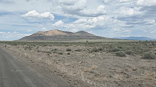
Pahvant Butte is a tuff cone volcano in the west-central portion of Utah, United States.
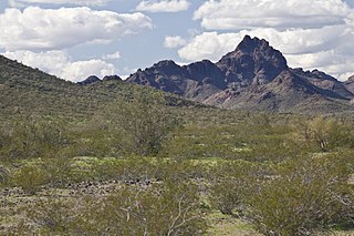
Sugarloaf Mountain, of Arizona is the tallest peak in the arid, low elevation Hummingbird Springs Wilderness of northwest Maricopa County, and about 65 miles (105 km) west of Phoenix. It rises in the Tonopah Desert about 10 miles (16 km) northwest of the Belmont Mountains. Hummingbird Springs Wilderness is just north of the Big Horn Mountains Wilderness. The two are separated only by a jeep trail that leads to Hummingbird Springs.

Tall Timber is an unincorporated community and a census-designated place (CDP) located in and governed by Boulder County, Colorado, United States. The CDP is a part of the Boulder, CO Metropolitan Statistical Area. The population of the Tall Timber CDP was 185 at the United States Census 2020. The Boulder post office serves the area.

Sugarloaf Mountain is a 900-foot (270 m) peak located in the town of Fishkill near the Hudson River and Breakneck Ridge. One of several similarly named mountains in the U.S. state of New York, it is part of the Hudson Highlands, located entirely within Hudson Highlands State Park.
