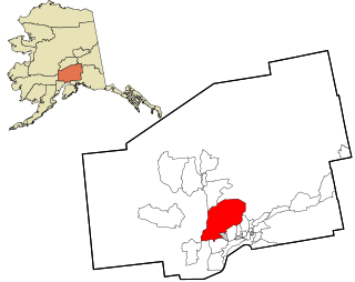
Willow is a census-designated place (CDP) in the Matanuska-Susitna Borough in the U.S. state of Alaska. Located 26 miles northwest from Wasilla along the George Parks Highway, it is part of the Anchorage, Alaska Metropolitan Statistical Area. At the 2020 census the population was 2,196, up from 2,102 in 2010.

The Edgerton Highway is a minor highway in the U.S. state of Alaska that extends 33 miles (53 km) from the Richardson Highway near Copper Center to the town of Chitina. The McCarthy Road, within the Wrangell-Saint Elias National Park and Preserve, is a 58-mile (93 km) extension from Chitina to McCarthy.

Beaver Creek is a 180-mile (290 km) tributary of the Yukon River in the U.S. state of Alaska. The creek begins at the confluence of Champion and Bear creeks in the White Mountains National Recreation Area, about 50 miles (80 km) north of Fairbanks. From there it flows west around the southern end of the White Mountains, then northeast into the Yukon Flats National Wildlife Refuge, then west into the Yukon River downstream of Beaver.

Wood-Tikchik State Park is a state park in the U.S. state of Alaska north of Dillingham. Over 1,600,000 acres (650,000 ha) (6,500 km2) in area—about the size of the state of Delaware—, comprising more than half of all state park land in Alaska and 15% of the total state park land in the country. Despite being the largest state park in the nation, the park had no staff whatsoever for its first five years, and even now at times only a single ranger is in charge of patrolling the entire park, usually by aircraft.

Chugach State Park covers 495,204 acres covering a hilly region immediately east of Anchorage, in south-central Alaska.

Denali State Park is a 325,240-acre (131,620 ha) state park in the U.S. state of Alaska. It is located in the Matanuska-Susitna Borough adjacent to the east side of Denali National Park and Preserve, along the Parks Highway.

Blue Knob State Park is a 6,128-acre (2,480 ha) Pennsylvania state park in Kimmel, Lincoln, and Pavia townships in Bedford County, Pennsylvania, in the United States. The average annual snowfall at the park is about 12 feet (370 cm). The park is named for Blue Knob, the second highest mountain in Pennsylvania at 3,146 feet (959 m). It is the location of Blue Knob All Seasons Resort, the ski slope in Pennsylvania with the highest elevation. Blue Knob State Park is just off Interstate 99 on Pennsylvania Route 869 west of Pavia.

Hatcher Pass is a mountain pass through the southwest part of the Talkeetna Mountains, Alaska. It is named after Robert Hatcher, a prospector and miner. The nearest cities are Palmer and Wasilla approximately 12 miles (19 km) to the south, and Willow approximately 26 mi (42 km) to the west. The communities are at an elevation of approximately 250 ft (76 m) in the Mat-Su valley.
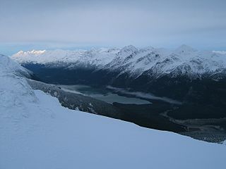
The Chilkoot Lake, in the Tlingit Indians region of Alaska, is also spelt Chilcoot Lake. Its other local names are the Akha Lake and Tschilkut S(ee), meaning "Chilkoot Lake". It is in Haines Borough, Alaska. Chilkoot also means "big fish". The lake has a ‘Recreation Site’ at its southern end near the outlet to the Chilkoot River, which is set amidst the Sitka spruce trees. Chilkoot River flows from the lake for a short length and debouches into the Lutak Channel at the head of the Chilkoot inlet near Haines. Chilkoot village, a settlement of Chilkoot Indians existed at the outlet of the lake, which was called Tschilkut or Tananel or Chilcoot; the lake is named after this village. This village is now a camping area developed by the State Parks and Outdoor Recreation Division of the Alaska Department of Natural Resources. The lake is a popular location for Kayaking.

Pinckney State Recreation Area is a Michigan state recreation area in Dexter, Sylvan and Lyndon Townships, Washtenaw County and Putnam and Unadilla Townships, Livingston County in the U.S. state of Michigan. The park is 11,000 acres (4,500 ha) and sits at an elevation of 922 feet (281 m). The park is connected to the nearby Waterloo State Recreation Area by the 35-mile (56 km) Waterloo–Pinckney Trail. Pinckney State Recreation Area is open for year-round recreation including hiking, fishing, swimming, hunting and a variety of winter sports.

The Snow Mountain Wilderness is a 60,076-acre (243.12 km2) federally designated wilderness area located 65 miles (105 km) north of Santa Rosa, California, USA in the Mendocino National Forest. The U.S. Congress passed the California Wilderness Act of 1984 which created 23 new wilderness areas including Snow Mountain. It lies within the North Coast Range of mountains.
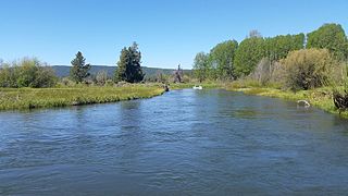
The Wood River is a short river in the southern region of the U.S. state of Oregon, and part of the Klamath Basin drainage. It flows 18 miles (29 km) through the Fremont-Winema National Forests, Bureau of Land Management land, and private property in southern Oregon. Its watershed consists of 220 square miles (570 km2) of conifer forest, rural pasture land, and marsh. The river provides habitat for many species of wildlife including an adfluvial (migratory) and resident populations of native Great Basin redband trout.

Lake Hudson State Recreation Area is a public recreation area located within southwestern Lenawee County in the U.S. state of Michigan. With its main entrance located along M-156, it is mostly located within Hudson Township and a very small portion extending south into neighboring Medina Township.
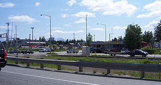
Wasilla (Dena'ina: Benteh) is a city in Matanuska-Susitna Borough, Alaska, United States, and the fourth-largest city in Alaska. It is located on the northern point of Cook Inlet in the Matanuska-Susitna Valley of the southcentral part of the state. The city's population was 9,054 at the 2020 census, up from 7,831 in 2010. Wasilla is the largest city in the borough and a part of the Anchorage metropolitan area, which had an estimated population of 398,328 in 2020.

Summit Lake is located above the tree line on the south slope of the Alaska Range between miles 192 and 196 of the Richardson Highway (AR-4). It is about 200 miles (320 km) north of Valdez, 180 miles (290 km) south of Fairbanks, and just south of Isabel Pass at an elevation of 3,300 feet (1,000 m). It is also situated within the northeast corner of the census-designated place of Paxson, about 15 miles (24 km) upstream (north) of Paxson Lake.

The Mount Adams Recreation Area is a 21,000-acre (8,500 ha) recreation area in the U.S. state of Washington managed by the Yakama Nation Tribal Forestry Program. The area encompasses an ecologically complex and geologically active landscape. The region features the most rugged side of Mount Adams, including canyons and the Great Gap section of the Mount Adams circumnavigation route, a three-mile trail-less section over two great canyons and many difficult glacial creeks. At 12,276 feet (3,742 m), Mount Adams is one of the major Cascade mountains. The recreation area is on the east side of the mountain and is part of the Yakama Indian Reservation and includes the popular Bird Creek Meadows area.

Crane Mountain is in the Warner Mountain range and is the tallest peak in Lake County, Oregon, U.S. It is located southeast of Lakeview in south-central Oregon, near the northwest corner of the Basin and Range Province of the western United States. The mountain is in the Fremont section of the Fremont–Winema National Forest. There was a United States Forest Service fire lookout located near the summit which was removed in 1972. The Crane Mountain National Recreation Trail runs north and south along the crest of the mountain.

Summit Lake is located on Canyon Creek in the Chugach National Forest, Alaska, United States and is situated along the Seward Highway (AK-1) 10 miles (16 km) north-northeast of Moose Pass and about 23 miles (37 km) southwest of the Portage area of Anchorage. The lake is fed by Canyon Creek from the southwest and Tenderfoot Creek from the east. The lake empties into Canyon Creek on the northeast, which flows through Lower Summit Lake, into Six Mile Creek, and eventually into the Turnagain Arm of the Cook Inlet.

Nancy Lake State Recreation Area is a 22,685 acres (9,180 ha) park near Willow in the Matanuska-Susitna Borough of Alaska. Founded on July 6, 1966, and set aside specifically for recreational use, the park is home to more than a hundred lakes as well as extensive wetlands. The landscape of the park was crafted in glacial retreats around 9,000 years ago, and around this same time the first inhabitants likely moved into the area. They were eventually followed by Russian exploration, and later increases in white settlement due to commerce and the presence of gold.