Sunwal सुनवल Sunawal, Golden Place, Golden Wall | |
|---|---|
| Mottoes: | |
 Sunwal  Sunwal  Sunwal | |
| Coordinates: 27°36′22″N83°39′38″E / 27.60611°N 83.66056°E type:city_region:NP|display=display=title, inline}} | |
| Country | |
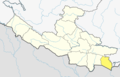
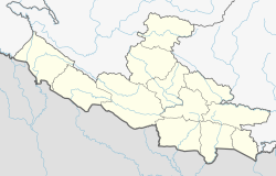
| Province | Lumbini |
| District | Nawalparasi (West of Bardaghat Susta) district |
| Founded by | Golden King |
| No. of Wards | 13 |
| Government | |
| • Type | Mayor–council government |
| • Body | Sunwal City Municipality Government |
| • Mayor | Bimala Aryal (UML) |
| • Deputy mayor | Surya Prasad Dubey (UML) |
| Area | |
| 173.50 km2 (66.99 sq mi) | |
| Elevation | 131 m (430 ft) |
| Population | |
| 72,621 | |
| • Rank | 27th |
| • Density | 419/km2 (1,090/sq mi) |
| • Metro | 0.11 million |
| • Municipal rank | 29th |
| Time zone | UTC+05:45 (Nepal Standard Time) |
| Postal Code | 33000 |
| Area code | 078 |
| Website | www |
Sunwal City, [a] officially the Sunwal Municipal City, [b] is the urbanized and the most populous city of Parasi District with 72,621 native inhabitants living in 18,689 households in 2021 [1] and 0.11 million people in its urban agglomeration. It is located in the Lumbini Province, at an altitude of 131 metres (430 feet).
Contents
The city is one of the oldest continuously inhabited places in Lumbini, founded in the 15th century. The city was historically called the "Sunawal" and has been the home of the Brahmin, Chhetri, Gurung, Magar and Newar people, a cosmopolitan urban civilization in the Himalayan foothills. Today, it runs with the local government of the Nepalese republic, established in 2015, and is part of the Lumbini Province.