São Valentim, district of Santa Maria

Last updated
District of São Valentim
São Valentim, the 2nd district of Santa Maria
District
Distrito.Sao Valentim.Santa Maria.RS.v2006.png
District of São Valentim, in Santa Maria City, Rio Grande do Sul, Brazil
Coordinates: 29°45′19.22″S53°56′59.52″W / 29.7553389°S 53.9498667°W / -29.7553389; -53.9498667 Coordinates: 29°45′19.22″S53°56′59.52″W / 29.7553389°S 53.9498667°W / -29.7553389; -53.9498667
Country Brazil
State Rio Grande do Sul
municipality/City Santa Maria
Government
  Type Subprefecture
  Body Subprefect
Area
   District 133.38 km2 (51.50 sq mi)
Highest elevation 150 m (492 ft)
Lowest elevation 60 m (197 ft)
Population [1]
   District 565
  Rank 9th of 10
  Density 4.2/km2 (11/sq mi)
   Urban 14
   Rural 551
Neighbourhoods 1
Adjacent districts Boca do Monte, Pains, Santa Flora, Sede
Website Official site of Santa Maria

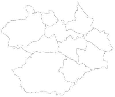
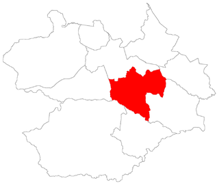
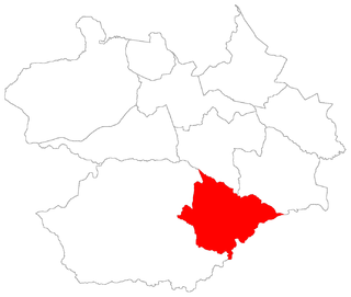
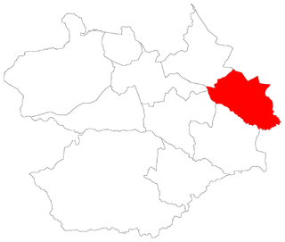
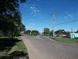
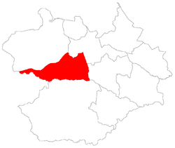
São Valentim [2] ("Saint Valentine") is a district of the municipality of Santa Maria, in the Brazilian state of Rio Grande do Sul. It is situated in the west portion of Santa Maria. The district's seat is 12 km (7.46 miles) far from Downtown Santa Maria.

Saint Valentine Roman saint

Saint Valentine, officially Saint Valentine of Rome, was a widely recognized 3rd-century Roman saint, commemorated in Christianity on February 14 and since the High Middle Ages is associated with a tradition of courtly love.

District Administrative division, in some countries, managed by local government

A district is a type of administrative division that, in some countries, is managed by local government. Across the world, areas known as "districts" vary greatly in size, spanning regions or counties, several municipalities, subdivisions of municipalities, school district, or political district.

Municipalities of Brazil administrative division of the states in Brazil

The municipalities of Brazil are administrative divisions of the Brazilian states. At present, Brazil has 5,570 municipalities, making the average municipality population 34,361. The average state in Brazil has 214 municipalities. Roraima is the least subdivided state, with 15 municipalities, while Minas Gerais is the most subdivided state, with 853.

Contents

The district of São Valentim owns an area of 133.38 km² that is equivalent to 7.44% of the municipality of Santa Maria that is 1791,65 km².

Santa Maria, Rio Grande do Sul Municipality in South, Brazil

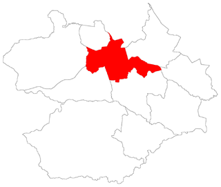
Santa Maria is a municipality (município) in the central region of Rio Grande do Sul, the southernmost state of Brazil. In 2017, its population was 278,445 inhabitants in a total area of 1,823 square kilometres (704 sq mi). Santa Maria is the 5th biggest municipality in the state, and the largest in its micro-region.

History

São Valentim was born in 1997 by the separation from district of Boca do Monte due to geographic factors and inhabitants' will.

Boca do Monte, district of Santa Maria District in Rio Grande do Sul, Brazil

Boca do Monte is a district of the municipality of Santa Maria, in the Brazilian state of Rio Grande do Sul. It is situated in the northwest portion of Santa Maria. The district's seat is located 16 km from Downtown Santa Maria.

Limits

The district limits with the districts of Boca do Monte, Pains, Santa Flora and Sede, and with the municipality of Dilermando de Aguiar.

Pains, district of Santa Maria District in Rio Grande do Sul, Brazil

Pains is a district of the municipality of Santa Maria, in the Brazilian state of Rio Grande do Sul. It is situated in the central portion of Santa Maria. The district's seat is 15 km far from Downtown Santa Maria.

Santa Flora, district of Santa Maria District in Rio Grande do Sul, Brazil

Santa Flora is a district of the municipality of Santa Maria, in the Brazilian state of Rio Grande do Sul. It is situated in the south portion of Santa Maria. The district's seat is located 36 km from Downtown Santa Maria.

Sede, district of Santa Maria District in Rio Grande do Sul, Brazil

Sede ("Seat") is a district of the municipality of Santa Maria, in the Brazilian state of Rio Grande do Sul. It is situated in the north portion of Santa Maria. Downtown Santa Maria is one of its bairros (neighbourhoods).

Neighbourhoods

The district of São Valentim is divided in the following bairros, that in English is equivalent to neighbourhoods:

Bairro community or region within a Portuguese-speaking city or municipality

A bairro is a Portuguese word for a quarter or a neighborhood or, sometimes, a district within a city or town. It is commonly used in Brazil, Mozambique, Guinea-Bissau, Portugal and other Portuguese-speaking places. Bairro is cognate with Germanic berg, burg, borg, burgh, borough etc, and Spanish barrio, all of which descend from the same Proto-Indo European root.

Neighbourhood geographically localized community within a larger city, town, suburb or rural area

A neighbourhood, or neighborhood, is a geographically localised community within a larger city, town, suburb or rural area. Neighbourhoods are often social communities with considerable face-to-face interaction among members. Researchers have not agreed on an exact definition, but the following may serve as a starting point: "Neighbourhood is generally defined spatially as a specific geographic area and functionally as a set of social networks. Neighbourhoods, then, are the spatial units in which face-to-face social interactions occur—the personal settings and situations where residents seek to realise common values, socialise youth, and maintain effective social control."

Roads and railway

Highway A public road or other public way on land

A highway is any public or private road or other public way on land. It is used for major roads, but also includes other public roads and public tracks: It is not an equivalent term to controlled-access highway, or a translation for autobahn, autoroute, etc.

BR-158 highway in Brazil

BR-158 is a federal highway of Brazil. One of the longest highways in the country, the 3,946.2-kilometre (2,452.1 mi) road connects Altamira, Pará, to Santana do Livramento on the Uruguayan border where it joins Route 5 (Uruguay).

Related Research Articles

This is a list of the administrative divisions of the municipality of Santa Maria, in the Brazilian state of Rio Grande do Sul.

Arroio do Só, district of Santa Maria District in Rio Grande do Sul, Brazil

Arroio do Só is a district of the municipality of Santa Maria, in the Brazilian state of Rio Grande do Sul. It is situated in the east portion of Santa Maria. The district's seat is located 36 km from Downtown Santa Maria, and, is situated closely to limit with the district of Palma and limits with the municipality of Restinga Seca.

Arroio Grande, district of Santa Maria District in Rio Grande do Sul, Brazil

Arroio Grande is a district of the municipality of Santa Maria, in the Brazilian state of Rio Grande do Sul. It is situated in the north portion of Santa Maria. The district's seat is located 18 km from Downtown Santa Maria. The district is known as the portal to Fourth Colony of Italian Immigration.

Passo do Verde, district of Santa Maria District in Rio Grande do Sul, Brazil

Passo do Verde is a district of the municipality of Santa Maria, in the Brazilian state of Rio Grande do Sul. It is situated in the south portion of Santa Maria. The district's seat is located 23 km from Downtown Santa Maria, nearby the Vacacaí River close to the boundary of Santa Maria with São Sepé.

Palma, district of Santa Maria District in Rio Grande do Sul, Brazil

Palma ("palm") is a district of the municipality of Santa Maria in the Brazilian state of Rio Grande do Sul. It is situated in north-eastern Santa Maria. The district's seat is located in its geographic center, 23 km from Downtown Santa Maria.

Santo Antão, district of Santa Maria District in Rio Grande do Sul, Brazil

Santo Antão is a district of the municipality of Santa Maria, in the Brazilian state of Rio Grande do Sul. It is situated in the north portion of Santa Maria. The district's seat is 11 km far from Downtown Santa Maria.

Arroio do Só Bairro in Rio Grande do Sul, Brazil

Arroio do Só is a bairro in the District of Arroio do Só in the municipality of Santa Maria, in the Brazilian state of Rio Grande do Sul. It is located in east Santa Maria.

São José, Santa Maria Bairro in Rio Grande do Sul, Brazil

São José is a bairro in the District of Sede in the municipality of Santa Maria, in the Brazilian state of Rio Grande do Sul. It is located in east Santa Maria.

Arroio Grande, Santa Maria Bairro in Rio Grande do Sul, Brazil

Arroio Grande is a bairro in the District of Arroio Grande in the municipality of Santa Maria, in the Brazilian state of Rio Grande do Sul. It is situated in northeast of Santa Maria.

Urlândia Bairro in Rio Grande do Sul, Brazil

Urlândia is a bairro in the District of Sede in the municipality of Santa Maria, in the Brazilian state of Rio Grande do Sul. It is located in south Santa Maria.

Uglione Bairro in Rio Grande do Sul, Brazil

Uglione is a bairro in the District of Sede in the municipality of Santa Maria, in the Brazilian state of Rio Grande do Sul. It is located in center-west Santa Maria.

São João, Santa Maria Bairro in Rio Grande do Sul, Brazil

São João is a bairro in the District of Sede in the municipality of Santa Maria, in the Brazilian state of Rio Grande do Sul. It is located in west Santa Maria.

Divina Providência Bairro in Rio Grande do Sul, Brazil

Divina Providência is a bairro in the District of Sede in the municipality of Santa Maria, in the Brazilian state of Rio Grande do Sul. It is located in north Santa Maria.

Camobi Bairro in Rio Grande do Sul, Brazil

Camobi is a bairro in the District of Sede in the municipality of Santa Maria, in the Brazilian state of Rio Grande do Sul. It is located in east Santa Maria.

São Valentim, Santa Maria Bairro in Rio Grande do Sul, Brazil

São Valentim is a bairro in the District of São Valentim in the municipality of Santa Maria, in the Brazilian state of Rio Grande do Sul. It is situated in south of Santa Maria.

References