Sülm

Last updated
Sülm
Wappen Suelm.png
Coat of arms
Germany adm location map.svg
Red pog.svg
Sülm
Location of Sülm within Eifelkreis Bitburg-Prüm district
Sulm in BIT.svg
Coordinates: 49°55′17″N06°34′27″E / 49.92139°N 6.57417°E / 49.92139; 6.57417 Coordinates: 49°55′17″N06°34′27″E / 49.92139°N 6.57417°E / 49.92139; 6.57417
Country Germany
State Rhineland-Palatinate
District Eifelkreis Bitburg-Prüm
Municipal assoc. Bitburger Land
Government
   Mayor Hermann Schilz
Area
  Total 7.05 km2 (2.72 sq mi)
Elevation 340 m (1,120 ft)
Population (2015-12-31) [1]
  Total 433
  Density 61/km2 (160/sq mi)
Time zone CET/CEST (UTC+1/+2)
Postal codes 54636
Dialling codes 06562
Vehicle registration BIT
Website Sülm at the Bitburger Land website www.bitburgerland.de

Sülm is a municipality in the district of Bitburg-Prüm, in Rhineland-Palatinate, western Germany.

Bitburg-Prüm District in Rhineland-Palatinate, Germany

The Eifelkreis Bitburg-Prüm is a district in Rhineland-Palatinate, Germany. It is bounded by Luxembourg, Belgium and the districts of Euskirchen, Vulkaneifel, Bernkastel-Wittlich and Trier-Saarburg.

Rhineland-Palatinate State in Germany

Rhineland-Palatinate is a state of Germany.

Germany Federal parliamentary republic in central-western Europe

Germany, officially the Federal Republic of Germany, is a country in Central and Western Europe, lying between the Baltic and North Seas to the north, and the Alps to the south. It borders Denmark to the north, Poland and the Czech Republic to the east, Austria and Switzerland to the south, France to the southwest, and Luxembourg, Belgium and the Netherlands to the west.

Contents

Geography

Sülm lies in the Southwest Eifel, about 5 km southeast of the county town Bitburg. The area extends to the so-called "Bitburger plateau and covers an area of 705 ha, of which 65% are used for agriculture, with 24% is a relatively small proportion of forest existed.

Agriculture Cultivation of plants and animals to provide useful products

Agriculture is the science and art of cultivating plants and livestock. Agriculture was the key development in the rise of sedentary human civilization, whereby farming of domesticated species created food surpluses that enabled people to live in cities. The history of agriculture began thousands of years ago. After gathering wild grains beginning at least 105,000 years ago, nascent farmers began to plant them around 11,500 years ago. Pigs, sheep and cattle were domesticated over 10,000 years ago. Plants were independently cultivated in at least 11 regions of the world. Industrial agriculture based on large-scale monoculture in the twentieth century came to dominate agricultural output, though about 2 billion people still depended on subsistence agriculture into the twenty-first.

Forest dense collection of trees covering a relatively large area

A forest is a large area dominated by trees. Hundreds of more precise definitions of forest are used throughout the world, incorporating factors such as tree density, tree height, land use, legal standing and ecological function. According to the widely used Food and Agriculture Organization definition, forests covered 4 billion hectares (9.9×10⁹ acres) (15 million square miles) or approximately 30 percent of the world's land area in 2006.

History

Sülm and 634 are the places Welschbillig, Newel and Röhl with their churches and related of King Dagobert I (reign: 622-638, Trier-residence: 624 to 625) of the Church of St. Pauli pin Trier offered. At that time, Modoald bishop of Trier. 981 this gift in a deed of the Archbishop mentioned Egbert of Trier (bishop 977-993). Sülm is in that document was first mentioned as "Sulmana".

Welschbillig Place in Rhineland-Palatinate, Germany

Welschbillig is a municipality in the Trier-Saarburg district, in Rhineland-Palatinate, Germany.

A newel, also called a central pole or support column, is the central supporting pillar of a staircase. It can also refer to an upright post that supports the handrail of a stair banister. In stairs having straight flights it is the principal post at the foot of the staircase, but the term can also be used for the intermediate posts on landings and at the top of a staircase. Although its primary purpose is structural, newels have long been adorned with decorative trim and designed with different architectural styles.

Dagobert I Frankish king

Dagobert I was the king of Austrasia (623–634), king of all the Franks (629–634), and king of Neustria and Burgundy (629–639). He was the last king of the Merovingian dynasty to wield any real royal power. Dagobert was the first of the Frankish kings to be buried in the royal tombs at Saint Denis Basilica.

Attractions

There are numerous renovated farm houses scattered about the municipality. The old war memorial chapel with a sandstone altar dates from 1631. There are also interesting grave markers from the 16th and 17th centuries in the Sülm Cemetery smau . In contrast to most of the burial sites in the Eifel district, several Sülm grave stones from the late 19th century have been preserved in the cemetery.

Farmhouse main house of a farm

A farmhouse is a building that serves as the primary residence in a rural or agricultural setting. Historically, farmhouses were often combined with space for animals called a housebarn. Other farmhouses may be connected to one or more barns, built to form a courtyard, or with each farm building separate from each other.

War memorial type of memorial

A war memorial is a building, monument, statue or other edifice to celebrate a war or victory, or to commemorate those who died or were injured in a war.

Church (building) building constructed for Christian worship

A church building or church house, often simply called a church, is a building used for Christian religious activities, particularly for Christian worship services. The term is often used by Christians to refer to the physical buildings where they worship, but it is sometimes used to refer to buildings of other religions. In traditional Christian architecture, the church is often arranged in the shape of a Christian cross. When viewed from plan view the longest part of a cross is represented by the aisle and the junction of the cross is located at the altar area.

Economy and infrastructure

Sülm is today an agricultural and tourist town. The village is home to several full- and part-time farms and three distilleries. In the services sector, it has a village inn, two private guest houses, a kindergarten and a public library.

Village Small clustered human settlement smaller than a town

A village is a clustered human settlement or community, larger than a hamlet but smaller than a town, with a population ranging from a few hundred to a few thousand. Though villages are often located in rural areas, the term urban village is also applied to certain urban neighborhoods. Villages are normally permanent, with fixed dwellings; however, transient villages can occur. Further, the dwellings of a village are fairly close to one another, not scattered broadly over the landscape, as a dispersed settlement.

Guest house Type of lodging

A guest house is a kind of lodging. In some parts of the world, guest houses are a type of inexpensive hotel-like lodging. In still others, it is a private home which has been converted for the exclusive use of guest accommodation. The owner usually lives in an entirely separate area within the property and the guest house may serve as a form of lodging business. This type of accommodation presents some major benefits such as:

Kindergarten preschool educational approach traditionally based on playing

Kindergarten is a preschool educational approach based on playing, singing, practical activities such as drawing, and social interaction as part of the transition from home to school. Such institutions were originally created in the late 18th century in Bavaria and Strasbourg to serve children whose parents both worked outside home. The term was coined by the German Friedrich Fröbel, whose approach globally influenced early-years education. Today, the term is used in many countries to describe a variety of educational institutions and learning spaces for children ranging from two to seven years of age, based on a variety of teaching methods.

About 2 km west of the village runs the Bundesstraße 51, which leads to Bitburg and about 10 km from the Bundesautobahn 60.

Bundesstraße 51 federal highway in Germany

The Bundesstraße 51 runs from Bremen in south-west direction though Lower Saxony, North Rhine-Westphalia, Rhineland-Palatinate and Saarland, and ends at the French border in the town Kleinblittersdorf.

Bundesautobahn 60 federal motorway in Germany

Bundesautobahn 60 is an autobahn in Germany. During its entire course it forms a part of the E 42.

Sons and daughters of the place

Related Research Articles

Oberkail Place in Rhineland-Palatinate, Germany

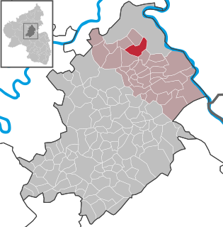
Oberkail is a municipality in the rural area of Eifel in Rhineland-Palatinate in the administrative district Bitburg-Prüm and is part of Verbandsgemeinde Bitburger Land.

Meisburg Place in Rhineland-Palatinate, Germany

Meisburg is an Ortsgemeinde – a municipality belonging to a Verbandsgemeinde, a kind of collective municipality – in the Vulkaneifel district in Rhineland-Palatinate, Germany. It belongs to the Verbandsgemeinde of Daun, whose seat is in the like-named town. In Meisburg, a Moselle Franconian dialect is spoken.

Hillesheim Place in Rhineland-Palatinate, Germany

Hillesheim is the third largest town in the Vulkaneifel district in Rhineland-Palatinate, Germany. It was the seat of the former Verbandsgemeinde Hillesheim.

Speicher, Germany Place in Rhineland-Palatinate, Germany

Speicher is a town in the county of Bitburg-Prüm, in Rhineland-Palatinate, Germany. It is situated in the Eifel, on the river Kyll, approximately 10 km south-east of Bitburg and 29 km north of Trier. It has 3,179 inhabitants and is next to the Spangdahlem Air Base which is home of the 52d Fighter Wing. There is a small monument to the men who lost their lives in the First and Second World Wars at the western end of the town. East of the monument is an open area for shopping and other events. Directly to the south is the parish church of St. Philip and St. James.

Kelberg Place in Rhineland-Palatinate, Germany

Kelberg is an Ortsgemeinde – a municipality belonging to a Verbandsgemeinde, a kind of collective municipality – in the Vulkaneifel district in Rhineland-Palatinate, Germany. It belongs to the like-named Verbandsgemeinde, and is home to its seat. Kelberg is a state-recognized climatic spa.

Erp (Germany) human settlement in Germany

Erp is a village in North Rhine-Westphalia, Germany. It has about 2650 inhabitants (2006).

Landscheid Place in Rhineland-Palatinate, Germany

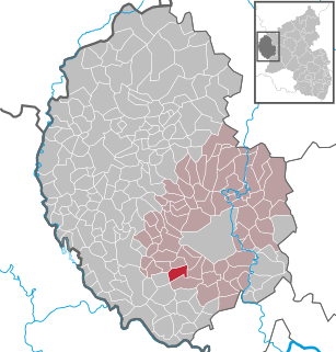
Landscheid is an Ortsgemeinde – which is a municipality belonging to a Verbandsgemeinde, a kind of collective municipality – in the Bernkastel-Wittlich district of Rhineland-Palatinate, Germany.

Binsfeld Place in Rhineland-Palatinate, Germany

Binsfeld near Wittlich in the Eifel is an Ortsgemeinde – a municipality belonging to a Verbandsgemeinde, a kind of collective municipality – in the Bernkastel-Wittlich district in Rhineland-Palatinate, Germany. Nearby is the American Spangdahlem Air Base.

Dockendorf Place in Rhineland-Palatinate, Germany

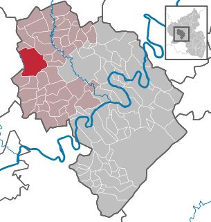
Dockendorf is a municipality in the district of Bitburg-Prüm, in Rhineland-Palatinate, western Germany.

Lascheid Place in Rhineland-Palatinate, Germany

Lascheid is a municipality in the district of Bitburg-Prüm, in Rhineland-Palatinate, western Germany.

Utscheid Place in Rhineland-Palatinate, Germany

Utscheid is a municipality in the district of Bitburg-Prüm, in Rhineland-Palatinate, western Germany.

Halsenbach Place in Rhineland-Palatinate, Germany

Halsenbach is an Ortsgemeinde – a municipality belonging to a Verbandsgemeinde, a kind of collective municipality – in the Rhein-Hunsrück-Kreis (district) in Rhineland-Palatinate, Germany. It belongs to the Verbandsgemeinde of Emmelshausen, whose seat is in the like-named town.

Bleckhausen Place in Rhineland-Palatinate, Germany

Bleckhausen is an Ortsgemeinde – a municipality belonging to a Verbandsgemeinde, a kind of collective municipality – in the Vulkaneifel district in Rhineland-Palatinate, Germany. It belongs to the Verbandsgemeinde of Daun, whose seat is in the like-named town.

Hohenfels-Essingen Place in Rhineland-Palatinate, Germany

Hohenfels-Essingen is an Ortsgemeinde – a municipality belonging to a Verbandsgemeinde, a kind of collective municipality – in the Vulkaneifel district in Rhineland-Palatinate, Germany. It belongs to the Verbandsgemeinde of Gerolstein, whose seat is in the like-named town.

Salm, Germany Place in Rhineland-Palatinate, Germany

Salm is an Ortsgemeinde – a municipality belonging to a Verbandsgemeinde, a kind of collective municipality – in the Vulkaneifel district in Rhineland-Palatinate, Germany. It belongs to the Verbandsgemeinde of Gerolstein, whose seat is in the like-named town.

Sarmersbach Place in Rhineland-Palatinate, Germany

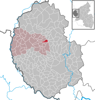
Sarmersbach is an Ortsgemeinde – a municipality belonging to a Verbandsgemeinde, a kind of collective municipality – in the Vulkaneifel district in Rhineland-Palatinate, Germany. It belongs to the Verbandsgemeinde of Daun, whose seat is in the like-named town.

Steineberg Place in Rhineland-Palatinate, Germany

Steineberg is an Ortsgemeinde – a municipality belonging to a Verbandsgemeinde, a kind of collective municipality – in the Vulkaneifel district in Rhineland-Palatinate, Germany. It belongs to the Verbandsgemeinde of Daun, whose seat is in the like-named town.

Winkel, Rhineland-Palatinate Place in Rhineland-Palatinate, Germany

Winkel is an Ortsgemeinde – a municipality belonging to a Verbandsgemeinde, a kind of collective municipality – in the Vulkaneifel district in Rhineland-Palatinate, Germany. It belongs to the Verbandsgemeinde of Daun, whose seat is in the like-named town.

References