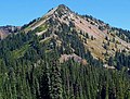
Tahtlum Peak

Last updated
Tahtlum Peak
Tahtlum Peak with snow cover.jpg
Tahtlum Peak seen from Highway 410
Highest point
Elevation 6,567 ft (2,002 m) [1]
Prominence 1,135 ft (346 m) [1]
Isolation 1.6 mi (2.6 km) [2]
Coordinates 46°51′52″N121°28′39″W / 46.864374°N 121.477472°W / 46.864374; -121.477472 Coordinates: 46°51′52″N121°28′39″W / 46.864374°N 121.477472°W / 46.864374; -121.477472
Geography
USA Washington relief location map.jpg
Red triangle with thick white border.svg
Tahtlum Peak
Location of Tahtlum Peak in Washington
Usa edcp relief location map.png
Red triangle with thick white border.svg
Tahtlum Peak
Tahtlum Peak (the United States)
Location Yakima County, Washington, U.S.
Parent range Cascades
Topo map USGS Cougar Lake
Climbing
Easiest route Hiking class 2

Tahtlum Peak is a 6,567-foot-elevation (2,002 meter) mountain summit located east-southeast of Chinook Pass in the William O. Douglas Wilderness. It's situated north of Dewey Lake in Yakima County of Washington state. Tahtlum Peak is part of the Cascade Range and its nearest higher neighbor is Dewey Peak, 1.61 mi (2.59 km) to the south. [1] The name tahtlum derives from Chinook Jargon which means ten. [3] Precipitation runoff from Tahtlum Peak drains into tributaries of the Yakima River.

Contents

Related Research Articles

Gifford Pinchot National Forest Protected area in the state of Washington, United States

Gifford Pinchot National Forest is a National Forest located in southern Washington, USA, managed by the United States Forest Service. With an area of 1.32 million acres (5300 km2), it extends 116 km along the western slopes of Cascade Range from Mount Rainier National Park to the Columbia River. The forest straddles the crest of the South Cascades of Washington State, spread out over broad, old growth forests, high mountain meadows, several glaciers, and numerous volcanic peaks. The forest's highest point is at 12,276 ft. at the top of Mount Adams, the second tallest volcano in the state after Rainier. Often found abbreviated GPNF on maps and in texts, it includes the 110,000-acre (450 km2) Mount St. Helens National Volcanic Monument, established by Congress in 1982.

Chinook Pass Pass through the Cascade Range

Chinook Pass is a pass through the Cascade Range in the state of Washington.

Wenatchee National Forest Protected area in the United States

Wenatchee National Forest is a U.S. National Forest located in Washington. With an area of 1,735,394 acres, it extends about 137 miles along the eastern slopes of the Cascade Range of Washington, USA from Okanogan National Forest to Gifford Pinchot National Forest. The forest is located in Chelan, Kittitas and Yakima counties.

Norse Peak Wilderness

Norse Peak Wilderness is a 52,315-acre (21,171 ha) designated wilderness area located in central Washington in the United States. It protects the portion of the Cascade Range north of Chinook Pass, south of Naches Pass, and east of Mount Rainier National Park. It is bordered by the William O. Douglas Wilderness to the south. The wilderness is named for a prominent peak which overlooks Crystal Mountain Ski Area. Roughly triangular, it is about 10 miles (16 km) across and contains no roads.

William O. Douglas Wilderness

The William O. Douglas Wilderness is a designated wilderness in Central Washington. It includes 169,081 acres (68,425 ha) located between the U.S. Route 12 and State Route 410 and is jointly administered by the Okanogan-Wenatchee National Forest and the Gifford Pinchot National Forest. It shares a boundary with the Mount Rainier National Park on the west; Norse Peak Wilderness lies to the north, Goat Rocks Wilderness to the south. Approximately 25 miles (40 km) of the Pacific Crest Trail travel along the Cascade Range crest within its boundaries. It contains scattered peaks, sharp ridges, steep slopes and hundreds of small lakes and potholes. Much of the wilderness is drained by tributaries of the Naches River.

Middle Santiam Wilderness

The Middle Santiam Wilderness is a wilderness area located near Mount Washington in the central Cascade Range of Oregon, U.S., within the Willamette National Forest.

Naches River River in the United States of America

The Naches River is a tributary of the Yakima River in central Washington in the United States. Beginning as the Little Naches River, it is about 75 miles (121 km) long. After the confluence of the Little Naches and Bumping River the name becomes simply the Naches River. The Naches and its tributaries drain a portion of the eastern side of the Cascade Range, east of Mount Rainier and northeast of Mount Adams. In terms of discharge, the Naches River is the largest tributary of the Yakima River.

American River (Washington)

The American River is a tributary of the Bumping River in Washington. It flows down the east side of the Cascade Range, through Wenatchee National Forest and the William O. Douglas Wilderness.

Cascades (ecoregion) Temperate coniferous forests ecoregion of the United States

The Cascades ecoregion is a Level III ecoregion designated by the United States Environmental Protection Agency (EPA) in the U.S. states of Washington, Oregon, and California. Somewhat smaller than the Cascade mountain range for which it is named, the ecoregion extends north to Snoqualmie Pass, near Seattle, and south to Hayden Pass, near the Oregon-California border, including the peaks and western slopes of most of the High Cascades. A discontiguous section is located on Mount Shasta in California.

Goose Prairie is an unincorporated community in Yakima County, Washington, United States. Goose Prairie is 41 miles (66 km) northwest of Yakima. It was founded by Tom Fife in 1886 who named it after a goose that visited the meadow one evening and stayed the night.

Chikamin Peak

Chikamin Peak is a 7,000+ ft mountain summit located in the cascade Range, in Kittitas County of Washington state. It is situated within the Alpine Lakes Wilderness, on land managed by the Okanogan–Wenatchee National Forest. The mountain's name "Chikamin" derives from Chinook Jargon meaning "money" or "metal", and was submitted by Edmond S. Meany, president of The Mountaineers. This name was officially adopted in 1916 by the U.S. Board on Geographic Names. Chikamin Peak is the highest point of Chikamin Ridge, 6 mi (9.7 km) northeast of Snoqualmie Pass. Other notable peaks on Chikamin Ridge include Four Brothers and Three Queens. Precipitation runoff from this mountain drains into tributaries of the Yakima River. The Pacific Crest Trail traverses the southwest slope of Chikamin Ridge, and from the trail a scramble up a gully leads to the summit and several alpine lakes including Chikamin Lake and Spectacle Lake.

Dewey Peak

Dewey Peak is a 6,710 feet (2,050 m) summit located on the shared border of Mount Rainier National Park and William O. Douglas Wilderness. It is also on the shared border of Pierce County and Yakima County in Washington state. Dewey Peak is situated on the crest of the Cascade Range southeast of Chinook Pass, east of Seymour Peak, and northeast of Shriner Peak. Its nearest higher peak is Chinook Peak, 3.97 mi (6.39 km) to the north. Dewey Peak is named in association with Dewey Lake which is set below its north aspect. Precipitation runoff from Dewey Peak drains into tributaries of the Cowlitz River and Yakima River.

Chinook Peak

Chinook Peak is a 6,904 feet (2,104 m) summit located on the eastern border of Mount Rainier National Park. It is also on the shared border of Pierce County and Yakima County in Washington state. Chinook Peak is situated north of Chinook Pass on the crest of the Cascade Range. Its nearest higher peak is Crystal Mountain, 1.31 mi (2.11 km) to the north. Crystal Peak lies 0.75 mi (1.21 km) to the northwest, and Cupalo Rock is 1.0 mi (1.6 km) to the east-northeast. Precipitation runoff from Chinook Peak drains into tributaries of the White River and Yakima River.

Naches Peak

Naches Peak is a 6,452-foot mountain summit located on the shared border of Mount Rainier National Park and William O. Douglas Wilderness. It is also on the shared border of Pierce County and Yakima County in Washington state. Naches Peak is situated on the crest of the Cascade Range and immediately southeast of Chinook Pass. Its nearest higher neighbor is Tahtlum Peak, 1.45 mi (2.33 km) to the east. The name Naches Peak was proposed by the Yakima Chamber of Commerce and approved by Asahel Curtis in 1927. The Naches Peak Loop Trail is a popular 3.5 mile trail encircling the peak. Precipitation runoff from the west side of Naches Peak drains into Chinook Creek, which is a tributary of the Ohanapecosh River, whereas the east side drains into tributaries of the American River.

Yakima Peak

Yakima Peak is a 6,226-ft summit located on the eastern border of Mount Rainier National Park. It is also on the shared border of Pierce County and Yakima County in Washington state. Yakima Peak is situated northwest of Tipsoo Lake and west of Chinook Pass on the crest of the Cascade Range. Its nearest higher neighbor is Deadwood Peak, 0.59 mi (0.95 km) to the north. The name Yakima Peak honors the Yakima Tribe of eastern Washington state. From Chinook Pass, a short scramble up a gully on the north side leads to a flat summit with unobstructed views of Mount Rainier and Naches Peak.

Deadwood Peak

Deadwood Peak is a 6,280-foot-elevation mountain summit located on the eastern border of Mount Rainier National Park. It is also situated on the shared border of Pierce County and Yakima County in Washington state. Deadwood Peak is set on the crest of the Cascade Range, immediately north of Yakima Peak and Chinook Pass, with the Pacific Crest Trail traversing its east slope. Its nearest higher peak is Naches Peak, 0.59 mi (0.95 km) to the southeast. Deadwood Peak takes its name from Deadwood Lakes and Deadwood Creek to its northwest, and their names came from the large number of downed trees in the area. From Chinook Pass, a short scramble up the south side leads to the summit with unobstructed views of Mount Rainier.

Fifes Peaks Mountains in Washington state

Fifes Peaks is a compact group of summits and spires from an eroded volcanic cone located in Yakima County in Washington state. Fifes Peaks is situated in the Cascade Range on the east side of the crest, within the Norse Peak Wilderness. The Fifes Peaks are remnants of a now extinct caldera which exploded 25 million years ago.

Selah Gap is a water gap carved by the Yakima River through the Yakima Ridge basalt formation between Yakima, Washington and Selah, Washington. The gap is traversed by BNSF Railway, Interstate 82, and Washington State Route 823. The Yakima Greenway trail for non motorized users also crosses the Yakima River at Selah Gap on an 1884 railroad bridge. The William O. Douglas Trail, named for William O. Douglas who hiked there from his home in Yakima, also crosses the gap and ascends the ridge on its way to Mount Rainier.

Mount Aix

Mount Aix is a 7,766-foot (2,367 m) mountain summit centrally located in the William O. Douglas Wilderness on land administered by the Wenatchee National Forest, and is the highest point in that wilderness area. It is also 24 miles east-southeast of Mount Rainier in Yakima County of Washington state. Mount Aix is situated east of the crest of the Cascade Range, southeast of Bumping Lake, north of Bismarck Peak, and northwest of Rimrock Lake. Its nearest higher peak is Tieton Peak in the Goat Rocks Wilderness, 19.9 mi (32.0 km) to the south-southwest. Mount Aix is the highest peak in the entire region which is east of Mount Rainier National Park, north of Goat Rocks Wilderness, west of Yakima, and south of Mount Daniel, so it is quite prominent. Prior to 1897 the name was spelled as Mount Aiks on early survey maps and publications.

Bismarck Peak

Bismarck Peak is a 7,585-foot-elevation mountain summit centrally located in the William O. Douglas Wilderness on land administered by the Wenatchee National Forest. It is also 24 miles east-southeast of Mount Rainier in Yakima County of Washington state. Bismarck Peak is situated east of the crest of the Cascade Range, southeast of Bumping Lake, south of Mount Aix, and northwest of Rimrock Lake. Its nearest higher peak is Mount Aix, 2.2 mi (3.5 km) to the north-northeast. Aix and Bismarck are the two highest peaks midway between Mount Rainier National Park and Yakima, Washington so they are quite prominent. Precipitation runoff from Bismarck Peak drains into tributaries of the Yakima River, thence into the Columbia River.

References

  1. 1 2 3 "Tahtlum Peak, Washington". Peakbagger.com.
  2. ""Tahtlum Peak" - 6,567' WA". listsofjohn.com. Retrieved 2020-06-13.
  3. "The Number System of Chinook Wawa".