Talipao

Last updated • 1 min readFrom Wikipedia, The Free Encyclopedia
Talipao
تاليڤااو
Municipality of Talipao
Mosque in Talipao.jpg
The Hadja Sitti Raya Mosque
Seal of Talipao.png
Ph locator sulu talipao.png
Map of Sulu with Talipao highlighted
OpenStreetMap
Talipao
Philippines location map (square).svg
Red pog.svg
Talipao
Location within the Philippines
Coordinates: 5°58′34″N121°06′31″E / 5.976031°N 121.108744°E / 5.976031; 121.108744
Country Philippines
Region Zamboanga Peninsula
Province Sulu
District 1st district
Barangays 52 (see Barangays)
Government
[1]
  Type Sangguniang Bayan
   Mayor Nivocadnezar I. Tulawie
   Vice Mayor Zulficar T. Tulawie
   Representative Samier A. Tan
   Municipal Council
Members
   Electorate 29,585 voters (2022)
Area
[2]
  Total380.57 km2 (146.94 sq mi)
Elevation
157 m (515 ft)
Highest elevation
506 m (1,660 ft)
Lowest elevation
0 m (0 ft)
Population
 (2020 census) [3]
  Total100,088
  Density260/km2 (680/sq mi)
   Households
15,853
Economy
   Income class 1st municipal income class
   Poverty incidence
54.10
% (2021) [4]
   Revenue 259.3 million (2020)
   Assets 300.6 million (2020)
   Expenditure 213 million (2020)
   Liabilities 32.74 million (2020)
Service provider
  ElectricitySulu Electric Cooperative (SULECO)
Time zone UTC+8 (PST)
ZIP code
7403
PSGC
IDD : area code +63(0)68
Native languages Tausug
Tagalog
Website www.talipao.gov.ph

Talipao, officially the Municipality of Talipao (Tausūg: Kawman sin Talipao; Tagalog : Bayan ng Talipao), is a 1st class municipality in the province of Sulu, Philippines. According to the 2015 census, it has a population of 80,255 people. [5]

Contents

Etymology

The municipality of Talipao derived its name from a certain couple, “Tal” and “Pao”, that of the husband's and wife's name respectively.

History

From the district of Jolo, it was transformed into a full-pledged municipality on July 1, 1957, under the provision of the Department of Mindanao and Sulu Administrative Code. On March 7, 1984, Talipao was renamed as Arolas Tulawie by virtue of Batas Pambansa Blg. 692 [6] but was rejected in a plebiscite.

Geography

The Municipality of Talipao's total area coverage is approximately 497.32 square kilometres or 49,732 hectares. [7] This constitute more or less 20.63% of Sulu's total land area. It is bounded on the north by the municipality of Patikul; on the south by Sulu Sea; on the east by the municipality of Panglima Estino; and by the municipality of Maimbung on its west side.

The municipality of Talipao lies right in the mid portion of Jolo island with its Barangay Poblacion basically situated in the innermost central part of the municipality. From the capital town of Jolo, Talipao is connected with concrete-type national road which is approximately 22.8 kilometres (14.2 mi) away from the Sulu Provincial Capitol Complex.

Barangays

Talipao is politically subdivided into 52 barangays. Each barangay consists of puroks while some have sitios.

  • Andalan
  • Bagsak
  • Bandang
  • Bilaan (Poblacion)
  • Bud Bunga
  • Buntod
  • Buroh
  • Dalih
  • Gata
  • Kabatuhan Bilaan
  • Kabatuhan Tiis
  • Kabungkol
  • Kagay
  • Kahawa
  • Kandaga
  • Kanlibot
  • Kiutaan
  • Kuhaw
  • Kulamboh
  • Kuttong
  • Lagtoh
  • Lambanah
  • Liban
  • Liu-Bud Pantao
  • Lower Binuang
  • Lower Kamuntayan
  • Lower Laus
  • Lower Sinumaan
  • Lower Talipao
  • Lumbayao
  • Lumping Pigih Daho
  • Lungkiaban
  • Mabahay
  • Mahala
  • Mampallam
  • Marsada
  • Mauboh
  • Mungit-mungit
  • Niog-Sangahan
  • Pantao
  • Samak
  • Talipao Proper
  • Tampakan
  • Tiis
  • Tinggah
  • Tubod
  • Tuyang
  • Upper Binuang
  • Upper Kamuntayan
  • Upper Laus
  • Upper Sinumaan
  • Upper Talipao

Climate

Climate data for Talipao, Sulu
MonthJanFebMarAprMayJunJulAugSepOctNovDecYear
Mean daily maximum °C (°F)27
(81)
27
(81)
27
(81)
28
(82)
28
(82)
28
(82)
28
(82)
28
(82)
28
(82)
28
(82)
28
(82)
27
(81)
28
(82)
Mean daily minimum °C (°F)26
(79)
26
(79)
26
(79)
27
(81)
27
(81)
27
(81)
27
(81)
27
(81)
27
(81)
27
(81)
27
(81)
27
(81)
27
(81)
Average precipitation mm (inches)170
(6.7)
130
(5.1)
125
(4.9)
122
(4.8)
229
(9.0)
286
(11.3)
254
(10.0)
248
(9.8)
182
(7.2)
257
(10.1)
233
(9.2)
188
(7.4)
2,424
(95.5)
Average rainy days18.315.315.214.622.824.024.323.320.522.621.919.3242.1
Source: Meteoblue [8]

Demographics

Population census of Talipao
YearPop.±% p.a.
1918 5,871    
1939 11,064+3.06%
1948 8,650−2.70%
1960 18,553+6.56%
1970 32,111+5.63%
1975 15,612−13.47%
1980 25,853+10.61%
1990 66,261+9.87%
1995 66,568+0.09%
2000 73,015+2.00%
2007 85,920+2.27%
2010 75,173−4.75%
2015 80,255+1.25%
2020 100,088+4.44%
Source: Philippine Statistics Authority [5] [9] [10] [11]

Economy

Poverty Incidence of Talipao

10
20
30
40
50
60
70
80
90
2000
68.73
2003
56.62
2006
51.20
2009
59.76
2012
42.89
2015
58.05
2018
82.62
2021
54.10

Source: Philippine Statistics Authority [12] [13] [14] [15] [16] [17] [18] [19]

Related Research Articles

<span class="mw-page-title-main">Hadji Panglima Tahil</span> Municipality in Sulu, Philippines

Hadji Panglima Tahil, officially the Municipality of Hadji Panglima Tahil, is a 6th class municipality in the province of Sulu, Philippines. According to the 2020 census, it has a population of 7,906 people, making it the least populated municipality in the province.

<span class="mw-page-title-main">Indanan</span> Municipality in Sulu, Philippines

Indanan, officially the Municipality of Indanan, is a 3rd class municipality in the province of Sulu, Philippines. According to the 2020 census, it has a population of 93,168 people.

<span class="mw-page-title-main">Kalingalan Caluang</span> Municipality in Sulu, Philippines

Kalingalan Caluang, officially the Municipality of Kalingalan Caluang, is a 5th class municipality in the province of Sulu, Philippines. According to the 2020 census, it has a population of 39,549 people.

<span class="mw-page-title-main">Lugus, Sulu</span> Municipality in Sulu, Philippines

Lugus, officially the Municipality of Lugus, is a 5th class municipality in the province of Sulu, Philippines. According to the 2020 census, it has a population of 29,043 people.

<span class="mw-page-title-main">Maimbung</span> Municipality in Sulu, Philippines

Maimbung, officially the Municipality of Maimbung, is a 5th class municipality in the province of Sulu, Philippines. According to the 2020 census, it has a population of 59,597 people.

<span class="mw-page-title-main">Panamao</span> Municipality in Sulu, Philippines

Panamao, officially the Municipality of Panamao, is a 4th class municipality in the province of Sulu, Philippines. According to the 2020 census, it has a population of 49,849 people.

<span class="mw-page-title-main">Pandami</span> Municipality in Sulu, Philippines

Pandami, officially the Municipality of Pandami, is a 4th class municipality in the province of Sulu, Philippines. According to the 2020 census, it has a population of 33,177 people.

<span class="mw-page-title-main">Panglima Estino</span> Municipality in Sulu, Philippines

Panglima Estino, officially the Municipality of Panglima Estino, is a 5th class municipality in the province of Sulu, Philippines. According to the 2020 census, it has a population of 34,249 people.

<span class="mw-page-title-main">Pangutaran</span> Municipality in Sulu, Philippines

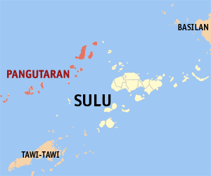
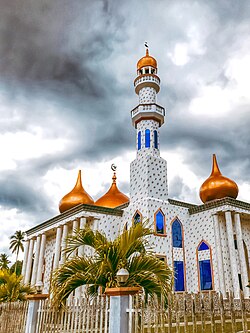
Pangutaran, officially the Municipality of Pangutaran, is a 4th class municipality in the province of Sulu, Philippines. According to the 2020 census, it has a population of 36,374 people.

<span class="mw-page-title-main">Parang, Sulu</span> Municipality in Sulu, Philippines

Parang, officially the Municipality of Parang, is a 2nd class municipality in the province of Sulu, Philippines. According to the 2020 census, it has a population of 71,495 people.

<span class="mw-page-title-main">Pata, Sulu</span> Municipality in Sulu, Philippines

Pata, officially the Municipality of Pata, is a 5th class municipality in the province of Sulu, Philippines. According to the 2015 census, it has a population of 22,163 people.

<span class="mw-page-title-main">Patikul</span> Municipality in Sulu, Philippines

Patikul, officially the Municipality of Patikul, is a 3rd class municipality in the province of Sulu, Philippines. According to the 2020 census, it has a population of 79,564 people. The provincial capitol and offices are located in this municipality.

<span class="mw-page-title-main">Siasi</span> Municipality in Sulu, Philippines

Siasi, officially the Municipality of Siasi, is a 2nd class municipality in the province of Sulu, Philippines. According to the 2020 census, it has a population of 81,689 people.

<span class="mw-page-title-main">Tapul</span> Municipality in Sulu, Philippines

Tapul, officially the Municipality of Tapul, is a 5th class municipality in the province of Sulu, Philippines. According to the 2015 census, it has a population of 18,197 people.

<span class="mw-page-title-main">Banguingui, Sulu</span> Municipality in Sulu, Philippines

Banguingui, officially the Municipality of Banguingui, is a 4th class municipality in the province of Sulu, Philippines. According to the 2020 census, it has a population of 35,616 people.

<span class="mw-page-title-main">Mapun</span> Municipality in Tawi-Tawi, Philippines

Mapun, officially the Municipality of Mapun, is a 4th class municipality in the province of Tawi-Tawi, Philippines. According to the 2020 census, it has a population of 30,038 people.

<span class="mw-page-title-main">Tandubas</span> Municipality in Tawi-Tawi, Philippines

Tandubas, officially the Municipality of Tandubas, is a 2nd class municipality in the province of Tawi-Tawi, Philippines. According to the 2020 census, it has a population of 34,316 people.

<span class="mw-page-title-main">Poona Bayabao</span> Municipality in Lanao del Sur, Philippines

Poona Bayabao, officially the Municipality of Poona Bayabao, is a 4th class municipality in the province of Lanao del Sur, Philippines. According to the 2020 census, it has a population of 31,141 people.

<span class="mw-page-title-main">Saguiaran</span> Municipality in Lanao del Sur, Philippines

Saguiaran, officially the Municipality of Saguiaran, is a 4th class municipality in the province of Lanao del Sur, Philippines. According to the 2020 census, it has a population of 26,712 people.

<span class="mw-page-title-main">Omar, Sulu</span> Municipality in Sulu, Philippines

Omar, officially the Municipality of Omar, is a municipality in the province of Sulu, Philippines. According to the 2020 census, it has a population of 28,070 people.

References

  1. Municipality of Talipao | (DILG)
  2. "2015 Census of Population, Report No. 3 – Population, Land Area, and Population Density" (PDF). Philippine Statistics Authority. Quezon City, Philippines. August 2016. ISSN   0117-1453. Archived (PDF) from the original on May 25, 2021. Retrieved July 16, 2021.
  3. Census of Population (2020). "Bangsamoro (BARMM)". Total Population by Province, City, Municipality and Barangay. Philippine Statistics Authority . Retrieved 8 July 2021.
  4. "PSA Releases the 2021 City and Municipal Level Poverty Estimates". Philippine Statistics Authority. 2 April 2024. Retrieved 28 April 2024.
  5. 1 2 Census of Population (2015). "ARMM – Autonomous Region in Muslim Mindanao". Total Population by Province, City, Municipality and Barangay. Philippine Statistics Authority . Retrieved 20 June 2016.
  6. "An Act Changing the Name of the Municipality of Talipao in the Province of Sulu to Municipality of Arolas Tulawie". Lawphil.net. Retrieved 28 February 2021.
  7. "_POPCEN Report No. 3.pdf" (PDF). Philippine Statistics Authority. Retrieved 25 May 2021.
  8. "Talipao, Sulu : Average Temperatures and Rainfall". Meteoblue. Retrieved 31 January 2019.
  9. Census of Population and Housing (2010). "ARMM – Autonomous Region in Muslim Mindanao" (PDF). Total Population by Province, City, Municipality and Barangay. National Statistics Office . Retrieved 29 June 2016.
  10. Censuses of Population (1903–2007). "ARMM – Autonomous Region in Muslim Mindanao". Table 1. Population Enumerated in Various Censuses by Province/Highly Urbanized City: 1903 to 2007. National Statistics Office.
  11. "Province of Sulu". Municipality Population Data. Local Water Utilities Administration Research Division. Retrieved 17 December 2016.
  12. "Poverty incidence (PI):". Philippine Statistics Authority. Retrieved December 28, 2020.
  13. "Estimation of Local Poverty in the Philippines" (PDF). Philippine Statistics Authority. 29 November 2005.
  14. "2003 City and Municipal Level Poverty Estimates" (PDF). Philippine Statistics Authority. 23 March 2009.
  15. "City and Municipal Level Poverty Estimates; 2006 and 2009" (PDF). Philippine Statistics Authority. 3 August 2012.
  16. "2012 Municipal and City Level Poverty Estimates" (PDF). Philippine Statistics Authority. 31 May 2016.
  17. "Municipal and City Level Small Area Poverty Estimates; 2009, 2012 and 2015". Philippine Statistics Authority. 10 July 2019.
  18. "PSA Releases the 2018 Municipal and City Level Poverty Estimates". Philippine Statistics Authority. 15 December 2021. Retrieved 22 January 2022.
  19. "PSA Releases the 2021 City and Municipal Level Poverty Estimates". Philippine Statistics Authority. 2 April 2024. Retrieved 28 April 2024.