
Warren County is a county located in the U.S. state of Mississippi. Its western border is formed by the Mississippi River. As of the 2020 census, the population was 44,722. Its county seat is Vicksburg. Established by legislative act of December 22, 1809, Warren County is named for American Revolutionary War officer Joseph Warren.

Issaquena County is a county located in the U.S. state of Mississippi. As of the 2020 Census, its population was 1,338, making it the least populous county in the United States east of the Mississippi River. Its county seat is Mayersville. With a per-capita income of $24,489, Issaquena County is, by that measure, the third-poorest county in the United States.
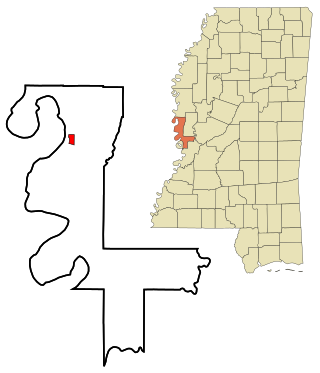
Mayersville is a town on the east bank of the Mississippi River, and the county seat for Issaquena County, Mississippi, United States. It is located in the Mississippi Delta region, known for cotton cultivation in the antebellum era. Once the trading center for the county, the town was superseded when railroads were built into the area. The population of the majority-black town was 547 at the 2010 census, down from 795 at the 2000 census.
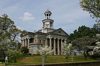
Vicksburg is a historic city in Warren County, Mississippi, United States. It is the county seat. The population was 21,573 at the 2020 census. Located on a high bluff on the east bank of the Mississippi River across from Louisiana, Vicksburg was built by French colonists in 1719. The outpost withstood an attack from the native Natchez people. It was incorporated as Vicksburg in 1825 after Methodist missionary Newitt Vick. The area that is now Vicksburg was long occupied by the Natchez Native Americans as part of their historical territory along the Mississippi. The first Europeans who settled the area were French colonists who built Fort Saint Pierre in 1719 on the high bluffs overlooking the Yazoo River at present-day Redwood. They conducted fur trading with the Natchez and others, and started plantations. During the American Civil War, it was a key Confederate river-port, and its July 1863 surrender to Ulysses S. Grant, along with the concurrent Battle of Gettysburg, marked the turning-point of the war.

The Vicksburg campaign was a series of maneuvers and battles in the Western Theater of the American Civil War directed against Vicksburg, Mississippi, a fortress city that dominated the last Confederate-controlled section of the Mississippi River. The Union Army of the Tennessee under Major General Ulysses S. Grant gained control of the river by capturing this stronghold and defeating Lieutenant General John C. Pemberton's forces stationed there.

Paul Octave Hébert was a soldier and politician who served as 14th Governor of Louisiana from 1853 to 1856. A veteran of the Mexican-American War, he later served as a brigadier general in the Confederate States Army.

Milliken's Bend is an extinct settlement that was located along the Mississippi River in Madison Parish, Louisiana, United States for about 100 years. In its heyday, the village had a boat landing, two streets of businesses, residences, churches, a four-room schoolhouse, a ferryman, and roads connecting it to Lake Providence, and Tallulah.

Hermann Lieb was a Swiss immigrant to the United States who served in the Union Army during the American Civil War. He is best remembered as the commander of the Union forces at the Battle of Milliken's Bend in 1863.

Mississippi Highway 465 is a highway in the southern region of the Mississippi Delta. The highway starts at U.S. Route 61 near Redwood. It travels westward towards the Mississippi River, and then northwards to the village of Eagle Bend. The highway then traverses on the Mississippi River levee on a one-lane road. Later, MS 465 leaves the levee, continues northward, and soon ends at MS 1.
Prentiss is a ghost town in Bolivar County, Mississippi, United States.
Victoria is a ghost town in Bolivar County, Mississippi, United States.

Duncansby is a ghost town in Issaquena County, Mississippi, United States.

Skipwith's Landing was a 19th-century boat landing and human settlement on the east bank of the Mississippi River, located in the county of Issaquena in the U.S. state of Mississippi. Skipwith's Landing was situated about 55 mi (89 km) to 100 mi (160 km) north of Vicksburg, Mississippi, depending on mode of travel. Circa 1866, a witness at a U.S. Congressional hearing described Skipwith's Landing as being among the most sparsely populated sections of the state with no village or town in proximity. Circa 1867, there were no roads leading to or from Skipwith's Landing; the only access was by the river. For a time there was a cut made by the river that was known as Skipwith's Chute. Another related placename was Skipwith Crevasse. There was a U.S. post office at Skipwith's in 1870.
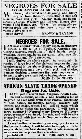
Aaron H. Forrest was one of the six Forrest brothers who engaged in the interregional slave trade in the United States prior to the American Civil War. He may have also owned or managed cotton plantations in Mississippi. He led a Confederate cavalry unit composed of volunteers from the Yazoo River region of Mississippi during the American Civil War. He died in 1864, apparently from illness.
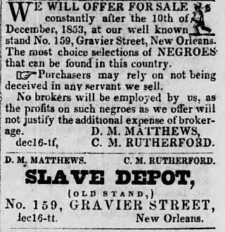
Calvin Morgan Rutherford, generally known as C. M. Rutherford, was a 19th-century American interstate slave trader. Rutherford had a wide geographic reach, trading nationwide from the Old Dominion of Virginia to as far west as Texas. Rutherford had ties to former Franklin & Armfield associates, worked in Kentucky for several years, advertised to markets throughout Louisiana and Mississippi, and was a major figure in the New Orleans slave trade for at least 20 years. Rutherford also invested his money in steamboats and hotels.

Josiah Maples was a 19th-century cotton plantation owner, bank director, and slave trader of Tennessee, Mississippi, and Arkansas in the United States. Maples is notable as a slave-trading business partner of Nathan Bedford Forrest.
Simeon Roe Adams was an American newspaper printer and politician. He served in the Mississippi State Senate from 1844 to 1848. He also owned the Eastern Clarion newspaper, a predecessor of The Clarion-Ledger, from 1839 to 1860.

Gaines Landing is an extinct settlement in Chicot County, Arkansas, United States that once hosted a boat landing along the Mississippi River. The location played a role in the story of fugitive slave Margaret Garner, and was used for troop movements during the American Civil War.

New Carthage, Louisiana, also known as Carthage Landing, was a 19th-century Mississippi River boat landing and village surrounded by cotton-producing agricultural land and undeveloped wetlands. New Carthage was located in, successively, Concordia Parish, Madison Parish, and Tensas Parish in Louisiana, United States. Destroyed by a combination of the American Civil War and the power of the Mississippi River, nothing remains of New Carthage today.


