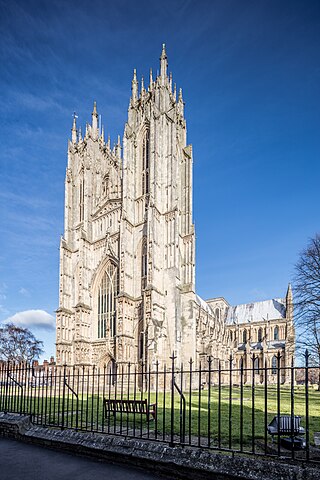
Beverley Minster, otherwise known as the Parish Church of Saint John and Saint Martin, in Beverley, East Riding of Yorkshire, is a parish church in the Church of England. It is one of the largest parish churches in the UK, larger than one-third of all English cathedrals and regarded as a Gothic masterpiece by many.

Chadlington is a village and civil parish in the Evenlode Valley about 3 miles (5 km) south of Chipping Norton, Oxfordshire. The village has five neighbourhoods: Brookend, Eastend, Greenend, Millend and Westend.

Appleton Wiske is a small village and civil parish that sits between Northallerton and Yarm in the Vale of York, a flat tract of land that runs between the North Yorkshire Moors to the east, the Yorkshire Dales to the west and the River Tees to the north.

Sherburn in Elmet is a town and civil parish in the Selby District of North Yorkshire, England, west of Selby and south of Tadcaster.

Holme-on-Spalding-Moor is a large village and civil parish in the East Riding of Yorkshire, England. It is situated approximately 8 miles (13 km) north-east of Howden and 5 miles (8 km) south-west of Market Weighton. It lies on the A163 road where it joins the A614 road.
Wressle is a village and civil parish in the East Riding of Yorkshire, England, lying on the eastern bank of the River Derwent approximately 3 miles (5 km) north-west of Howden.

Burton Fleming is a village and civil parish in the East Riding of Yorkshire, England. It lies close to the border with North Yorkshire. The village is situated approximately 7 miles (11 km) north-west of Bridlington and 6 miles (10 km) south of Filey.

Hemingbrough is a small village and civil parish in North Yorkshire, England that is located approximately 5 miles (8 km) from Selby and 4 miles (6.4 km) from Howden on the A63. It was in the historic East Riding of Yorkshire, but since 1974 has come under North Yorkshire. The village has a 12th-century former collegiate church, a Methodist chapel and shops. The village also has a primary school and nursery as well as a playing field for the local children. The surrounding area makes up part of the Humberhead Levels and is flat land mainly used for mixed agriculture. It is thought that from this village came Walter of Hemingbrough, one of Britain's early chroniclers. Writing in the 14th century, he gave us a history beginning with the Norman conquest, now in the British Museum.
York had around 45 parish churches in 1300. Twenty survive, in whole or in part, a number surpassed in England only by Norwich, and 12 are used for worship. This article consists of a list of medieval churches which still exist in whole or in part, and a list of medieval churches which are known to have existed in the past but have been completely demolished.

Howden Minster is a large Grade I listed Church of England church in the Diocese of York. It is located in Howden, East Riding of Yorkshire, England and is one of the largest churches in the East Riding. It is dedicated to St Peter and St Paul and it is therefore properly known as 'the Minster Church of St Peter and St Paul'. Its Grade I listed status also includes the Chapter House.
Kirtlington is a village and civil parish in Oxfordshire about 6+1⁄2 miles (10.5 km) west of Bicester. The parish includes the hamlet of Northbrook. The 2011 Census recorded the parish's population as 988.

Snaith is a market town and parish in the civil parish of Snaith and Cowick in the East Riding of Yorkshire, England. The town is close to the River Aire and the M62 and M18 motorways. The town is located 7 miles (11 km) west of Goole, 10 miles (16 km) east of Knottingley, 8 miles (13 km) south of Selby, 10 miles (16 km) southwest of Howden and 8 miles (13 km) northwest of Thorne.

Wharram-le-Street is a village and former civil parish, now in the parish of Wharram, in the Ryedale district of North Yorkshire, England. Until the 1974 local government reorganisation Wharram-le-Street was part of the East Riding of Yorkshire. The village is on the B1248 road between North Grimston and the boundary with the present East Riding of Yorkshire unitary authority. In 1931 the parish had a population of 133.

Cliffe is a small village and civil parish in North Yorkshire, England. It was historically part of the East Riding of Yorkshire until 1974, but from 1974 to 2023 was in the Selby District of the shire county of North Yorkshire. In 2023 the district was abolished and North Yorkshire became a unitary authority.

St Patrick's Church, Patrington is an Anglican parish church located in Patrington, East Riding of Yorkshire, England. The church is a Grade I listed building.

Sydenham is a village and civil parish about 3 miles (5 km) southeast of Thame in Oxfordshire. To the south the parish is bounded by the ancient Lower Icknield Way, and on its other sides largely by brooks that merge as Cuttle Brook, a tributary of the River Thame. The 2011 Census recorded the parish's population as 451.

The Parish Church of Saint Matthew, Langford is the Church of England parish church of Langford, a village in West Oxfordshire about 3 miles (5 km) northeast of Lechlade in neighbouring Gloucestershire.

St Mary's Church is an Anglican parish church in Beverley in the East Riding of Yorkshire, England. It is designated a Grade I listed building.

St Mary's Church is an Anglican parish church in the English village of Welwick in the East Riding of Yorkshire. It is a Grade I listed building.

St Nicholas' Church, Dunnington is a Grade II* listed parish church in Dunnington, a village in the rural south-eastern part of the City of York, in England.


