
Tewkesbury is a market town and civil parish in the north of Gloucestershire, England. The town grew following the construction of Tewkesbury Abbey in the twelfth century and played a significant role in the Wars of the Roses. It stands at the confluence of the River Severn and the River Avon, and thus became an important trading point, which continued as railways and, later, the M5 and M50 motorway connections were established. The town gives its name to the Borough of Tewkesbury, a local government district of Gloucestershire. The town lies on the border with Worcestershire, marked largely by the Carrant Brook.
Oldbury-on-Severn is a small village near the mouth of the River Severn in the South Gloucestershire district of the county of Gloucestershire in the west of England. The parish, which includes the village of Cowhill had a population at the 2011 census of 780. It is home to the nearby Oldbury nuclear power station, a Magnox power station which opened in 1967 and ceased operation on 29 February 2012.
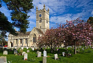
Bishop's Cleeve is a village and civil parish in the Borough of Tewkesbury in the ceremonial county of Gloucestershire, England. The village lies at the foot of Cleeve Hill, the highest point in the Cotswolds. Bishop's Cleeve had a population of 10,612 in 2011, which has increased to 14,068 in the 2021 Census. The village is 13 miles (21 km) from Gloucester and 44 miles (71 km) from Oxford. The village is also close to the towns of Cheltenham, Tewkesbury and Evesham.

Prestbury is a village and civil parish in the borough of Cheltenham in Gloucestershire, England. Located on the outskirts of Cheltenham and part of the Tewkesbury parliamentary constituency.

Minsterworth is a village in Gloucestershire, England. It lies on the border of the City of Gloucester, on the north bank of the River Severn and on the A48 road between Gloucester and Chepstow.

Stoke Orchard is a village or hamlet approximately 2.5 miles (4.0 km) northwest of Cheltenham in Gloucestershire, England.

Alderton is a village and civil parish in the Tewkesbury district of Gloucestershire, England.

Alstone is a village and former civil parish, now in the parish of Teddington, in the Tewkesbury district, in the county of Gloucestershire, England, situated between the towns of Tewkesbury and Winchcombe. In 1931 the parish had a population of 50.

Old Sodbury is a small village and former civil parish in the valley of the River Frome just below and to the west of the Cotswold escarpment and to the east of Chipping Sodbury and Yate, now in the parish of Sodbury, in the South Gloucestershire district, in the ceremonial county of Gloucestershire, England. It is situated in the Hundred of Grumbald's Ash. The village extends from Chipping Sodbury in the West to the Cotswold Edge in the East and is on the Cotswold Way. The Badminton Road (A432) winds eastwards towards Badminton, Gloucestershire through the village, up to the Cross Hands junction with the A46, which runs along the top of the Cotswold escarpment from Bath to Stroud. In 1931 the parish had a population of 837. On 1 April 1946 the parish was abolished to form Sodbury.
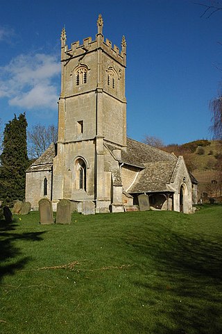
Shurdington is a village near Cheltenham in Gloucestershire, England. The area constitutes a civil parish within the Borough of Tewkesbury. It is located south of Cheltenham on the A46. The population at the 2011 census was 1,936 Shurdington has an 11th-century church, a modern Social Centre containing the Century Hall and Millennium Hall, a Primary School, a post office and general store and a hairdresser. There are two public houses: the Bell Inn and The Cheese Rollers. The latter is named for the annual cheeserolling event which takes place at nearby Cooper's Hill.

Dumbleton is a village and civil parish in the Tewkesbury district, in the county of Gloucestershire, England. The village is roughly 20 miles from the city of Gloucester. The village is known to have existed in the time of Æthelred I who granted land to Abingdon Abbey, and it is mentioned in the Domesday Book.

Gotherington is a small village north of Bishops Cleeve in Gloucestershire, England. It is surrounded on the north by the villages of Woolstone and Oxenton, and to the south by Woodmancote and Bishop's Cleeve, a very large urban village. Gotherington has a population of around 1,200, while its neighbour, Bishops Cleeve, has a population of 15,000. The populations reduced at the 2011 census to 995 for Gotherington.

Stanton is a village and civil parish in Tewkesbury Borough, Gloucestershire, England. The village is a spring line settlement at the foot of the Cotswold escarpment, about 2.5 miles (4 km) southwest of Broadway in neighbouring Worcestershire. Broadway is Stanton's postal town. The 2011 Census recorded the parish's population as 198.
Withington is a Cotswold village and civil parish in Gloucestershire, England, about 7 miles (11 km) southeast of Cheltenham and 8 miles (13 km) north of Cirencester. The River Coln runs through the village. The parish includes the hamlets of Hilcot, Foxcote and Cassey Compton. The parish population taken at the 2011 census was 532.
Twyning is a village and civil parish on the River Avon in the north of Gloucestershire, near Tewkesbury, England. The parish is first mentioned in the Liber Wigorniensis in about 1016, where it is called Tuinaeum, part of Gretestane in the county of Winchcombeshire and then mentioned in Domesday Book, described as "Tu(e)ninge, Kings Land : Winchcombe Abbey." The name derives from the Old English for "between the rivers"; despite its spelling, it is pronounced "twinning". The parish forms a land 'isthmus' into the county of Worcestershire.

Willersey is a village in Gloucestershire, South West England, situated close to the boundary with Worcestershire, West Midlands region and southwest of Evesham. Although situated in Gloucestershire, the postal county for the village is Worcestershire, due to it being covered by the Broadway post town. It is an old village with much character. There is a primary school and as well as a large park area. The duck pond is much admired by visitors to the village.

Toddington is a village and civil parish in north Gloucestershire in Tewkesbury Borough, located approximately 12 miles (19 km) north-east of Cheltenham with a population of 419 at the 2011 census.

Norton is a settlement and civil parish in the English county of Gloucestershire.
Oxenton is a village and civil parish 11 miles (18 km) north east of Gloucester, in the Tewkesbury district, in the county of Gloucestershire, England. In 2011 the parish had a population of 162. The parish touches Alderton, Ashchurch Rural, Gotherington, Teddington and Stoke Orchard. It is on the west side of Oxenton Hill, a northern outlier of the Cotswolds. Oxenton has a parish meeting.


