Tegošnica

Last updated
Tegošnica
Village
Serbia adm location map.svg
Red pog.svg
Tegošnica
Coordinates: 42°57′20″N22°14′31″E / 42.95556°N 22.24194°E / 42.95556; 22.24194
CountryFlag of Serbia.svg  Serbia
District Jablanica District
Municipality Vlasotince
Population (2002)
  Total 3
Time zone CET (UTC+1)
  Summer (DST) CEST (UTC+2)

Tegošnica is a village in the municipality of Vlasotince, Serbia. According to the 2002 census, the village has a population of 3 people. [1]

Village Small clustered human settlement smaller than a town

A village is a clustered human settlement or community, larger than a hamlet but smaller than a town, with a population ranging from a few hundred to a few thousand. Though villages are often located in rural areas, the term urban village is also applied to certain urban neighborhoods. Villages are normally permanent, with fixed dwellings; however, transient villages can occur. Further, the dwellings of a village are fairly close to one another, not scattered broadly over the landscape, as a dispersed settlement.

Vlasotince Town and municipality in Southern and Eastern Serbia, Serbia

Vlasotince is a town and municipality located in Jablanica District of southern Serbia. As of 2011, the municipality has 29,669 inhabitants, while the town itself has a population of 15,830 inhabitants.

Serbia Republic in Southeastern Europe

Serbia, officially the Republic of Serbia, is a country situated at the crossroads of Central and Southeast Europe in the southern Pannonian Plain and the central Balkans. The sovereign state borders Hungary to the north, Romania to the northeast, Bulgaria to the southeast, North Macedonia to the south, Croatia and Bosnia and Herzegovina to the west, and Montenegro to the southwest. The country claims a border with Albania through the disputed territory of Kosovo. Serbia's population is about seven million. Its capital, Belgrade, ranks among the oldest and largest citiеs in Europe.

Related Research Articles

Onsong County County in North Hamgyong Province, North Korea

Onsŏng County is a county (kun) in North Hamgyong Province, North Korea, located near the border with China. The administrative center is the town (ŭp) of Onsong. Onsong is the alleged site of the former Onsong concentration camp, now closed.

Laskár municipality of Slovakia

Laskár is a village and municipality in Martin District in the Žilina Region of northern Slovakia.

Wierzbice Village in Lower Silesian, Poland

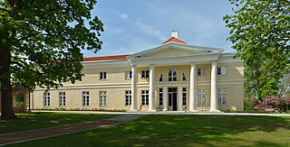
Wierzbice is a village in the administrative district of Gmina Kobierzyce, within Wrocław County, Lower Silesian Voivodeship, in south-western Poland. Prior to 1945 it was in Germany.

Krężnica Okrągła Village in Lublin Voivodeship, Poland

Krężnica Okrągła is a village in the administrative district of Gmina Bełżyce, within Lublin County, Lublin Voivodeship, in eastern Poland. It lies approximately 3 kilometres (2 mi) south-west of Bełżyce and 25 km (16 mi) west of the regional capital Lublin.

Zbysław, Pomeranian Voivodeship Village in Pomeranian, Poland

Zbysław is a village in the administrative district of Gmina Bytów, within Bytów County, Pomeranian Voivodeship, in northern Poland. It lies approximately 13 kilometres (8 mi) north of Bytów and 77 km (48 mi) west of the regional capital Gdańsk.

Jadwisin, Łódź Voivodeship Village in Łódź, Poland

Jadwisin is a village in the administrative district of Gmina Wartkowice, within Poddębice County, Łódź Voivodeship, in central Poland. It lies approximately 5 kilometres (3 mi) south-west of Wartkowice, 8 km (5 mi) north of Poddębice, and 41 km (25 mi) north-west of the regional capital Łódź.

Nowy Jamielnik is a village in the administrative district of Gmina Stoczek Łukowski, within Łuków County, Lublin Voivodeship, in eastern Poland.

Huta Szumy is a village in the administrative district of Gmina Susiec, within Tomaszów Lubelski County, Lublin Voivodeship, in eastern Poland.

Lewoszów Village in Świętokrzyskie, Poland

Lewoszów is a village in the administrative district of Gmina Radoszyce, within Końskie County, Świętokrzyskie Voivodeship, in south-central Poland. It lies approximately 4 kilometres (2 mi) south of Radoszyce, 22 km (14 mi) south-west of Końskie, and 32 km (20 mi) north-west of the regional capital Kielce.

Bronibór is a village in the administrative district of Gmina Szczytniki, within Kalisz County, Greater Poland Voivodeship, in west-central Poland.

Dębowiec, Myszków County Village in Silesian, Poland

Dębowiec is a village in the administrative district of Gmina Poraj, within Myszków County, Silesian Voivodeship, in southern Poland. It lies approximately 14 kilometres (9 mi) north of Myszków and 53 km (33 mi) north of the regional capital Katowice.

Kosten is a village in Sungurlare Municipality, in Burgas Province, in southeastern Bulgaria.

Ivan Kula Village in Toplica District, Serbia

Ivan Kula is a village in the municipality of Kuršumlija, Serbia. According to the 2002 census, the village has a population of 39 people.

Rajčetine Village in Jablanica District, Serbia

Rajčetine is a village in the municipality of Crna Trava, Serbia. According to the 2002 census, the village has a population of 33 people.

Šišince Village in Jablanica District, Serbia

Šišince is a village in the municipality of Leskovac, Serbia. According to the 2011 census, the village has a population of 603 people.

Vlase (Leskovac) Village in Jablanica District, Serbia

Vlase is a village in the municipality of Leskovac, Serbia. According to the 2002 census, the village has a population of 584 people.

Triigi, Harju County Village in Harju County, Estonia

Triigi is a village in Kose Parish, Harju County in northern Estonia.

Jančići Village in Moravica District, Serbia

Jančići is a village in the municipality of Čačak, Serbia. According to the 2011 census, the village has a population of 143 people.

Proštinac Village in Pomoravlje District, Serbia

Proštinac is a village in the municipality of Svilajnac, Serbia. According to the 2002 census, the village has a population of 254 people.

Grošnica Village in Šumadija District, Serbia

Grošnica is a village in the municipality of Stanovo, Serbia. According to the 2002 census, the village has a population of 1280 people.

References

  1. Popis stanovništva, domaćinstava i Stanova 2002. Knjiga 1: Nacionalna ili etnička pripadnost po naseljima. Republika Srbija, Republički zavod za statistiku Beograd 2003. ISBN   86-84433-00-9

Coordinates: 42°57′20″N22°14′31″E / 42.95556°N 22.24194°E / 42.95556; 22.24194

Geographic coordinate system Coordinate system

A geographic coordinate system is a coordinate system that enables every location on Earth to be specified by a set of numbers, letters or symbols. The coordinates are often chosen such that one of the numbers represents a vertical position and two or three of the numbers represent a horizontal position; alternatively, a geographic position may be expressed in a combined three-dimensional Cartesian vector. A common choice of coordinates is latitude, longitude and elevation. To specify a location on a plane requires a map projection.