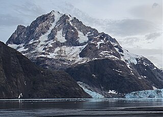
Mount Abbe is an 8200+ feet double summit mountain located in the Fairweather Range of the Saint Elias Mountains, in southeast Alaska. The peak is situated near the terminus of the Johns Hopkins Glacier, within Glacier Bay National Park and Preserve, 100 mi (161 km) northwest of Juneau, and 8.2 mi (13 km) northeast of Mount Orville. Although modest in elevation, relief is significant since the mountain rises up from tidewater in less than two miles. Mount Abbe is often seen and photographed with the Johns Hopkins Glacier, which is a popular destination for cruise ships. The mountain was named in 1936 by William Osgood Field and William Skinner Cooper, of the American Geographical Society, for Cleveland Abbe Jr., (1872-1934), an American geographer. Abbe received a Ph.D. in 1898 from Johns Hopkins University. The Gilman Glacier and Clark Glacier on the mountain's slopes were named for Daniel Coit Gilman, the institution's first president, and William Bullock Clark who was a professor of geology at the university. The mountain's name was officially adopted in 1937 by the United States Geological Survey. The first ascent of the south summit was made June 11, 1977, by Jim Wickwire and Dusan Jagersky via the Southeast Face. Three days later, Dusan Jagersky was killed while descending an unnamed peak. The first ascent of the north summit was made July 14, 1991, by Walter Gove and William Pilling. The months May through June offer the most favorable weather for climbing Mount Abbe, but it's a challenging climb in any conditions, with few attempts.
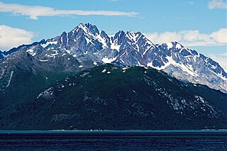
Mount Abdallah is a prominent 6,210-foot (1,893-meter) mountain summit located in the Alsek Ranges of the Saint Elias Mountains, in southeast Alaska. The mountain is situated in Glacier Bay National Park and Preserve, as the highest point between Tarr Inlet and Rendu Inlet, 93 mi (150 km) northwest of Juneau, and 10.5 mi (17 km) southeast of Mount Barnard, which is the nearest higher peak. Although modest in elevation, relief is significant since the mountain rises up from tidewater in less than three miles. The mountain was named in 1892 by Harry Fielding Reid, an American geophysicist, who in 1892 hired a small crew of men for an expedition to study glaciology in Glacier Bay. There is no record of who Reid named this mountain for, but a member of his expeditionary crew who accompanied him might be a possibility. The months May through June offer the most favorable weather for viewing Mount Abdallah. Weather permitting, Mount Abdallah can be seen from Glacier Bay, which is a popular destination for cruise ships.

Pyramid Peak is an 8,875-foot (2,705-meter) mountain summit located at the western edge of the Saint Elias Mountains, in the U.S. state of Alaska. The peak is situated in Wrangell-St. Elias National Park and Preserve, 22 mi (35 km) southeast of McCarthy, 7 mi (11 km) southeast of Williams Peak, and 6 mi (10 km) south-southeast of Joshua Green Peak. The peak's descriptive local name was reported in 1908 by the United States Geological Survey. Precipitation runoff from the mountain drains into tributaries of the Nizina River, which in turn is part of the Copper River drainage basin.

The Mitre is a 6,651-foot (2,027 m) mountain summit located in the western Chugach Mountains, in Anchorage Municipality in the U.S. state of Alaska. The mountain is situated in Chugach State Park, 30 mi (48 km) east of Anchorage, three miles (4.8 km) northeast of Bellicose Peak, and 5.5 mi (9 km) south-southeast of Eklutna Lake. The nearest higher peak is Benign Peak, 2.4 mi (4 km) to the west-northwest, on the opposite side of the Eklutna Glacier. Although modest in elevation, relief is significant since the western aspect of the mountain rises 4,000 feet above this glacier in approximately half a mile. In Europe, "mitre" is the term used for a sharp, symmetrical rocky peak such as this one. The Mitre's descriptive name was submitted for consideration by the Mountaineering Club of Alaska as suggested by Dr. Rodman Wilson (1921–2003) of Anchorage after he returned from a European vacation. The Mitre name was officially adopted in 1966 by the U.S. Board on Geographic Names. In the Denaʼina language, this mountain is known as Idlu Bena Dghelaya, meaning Mountain of Plural Objects Lake.

McHugh Peak is a 4,308-foot (1,313 m) mountain summit located in the western Chugach Mountains, in Anchorage Municipality, in the U.S. state of Alaska. McHugh Peak is situated in Chugach State Park, 14 mi (23 km) southeast of downtown Anchorage, and 5 mi (8 km) southwest of O'Malley Peak. Reaching the top involves hiking on a ridge trail and scrambling the final summit tor. The hike to McHugh Peak is detailed in several popular guidebooks. This geographic feature's local name was reported in 1942 by the Army Map Service, and was officially adopted in 1969 by the U.S. Board on Geographic Names. The mountain's name is derived from McHugh Creek which drains the south slope of this peak, and the creek's name was first published in 1912 by the United States Coast and Geodetic Survey. This mountain is called Q'isqa Dghelaya in the Denaʼina language, meaning Banjo Snowshoe Mountain. "Q'isqa" are temporary snowshoes made of lashed brush.

Calliope Mountain is a 6,821-foot (2,079 m) mountain summit located in the Chugach Mountains, in Anchorage Municipality in the U.S. state of Alaska. Calliope Mountain is situated in Chugach State Park, 20 mi (32 km) east-southeast of downtown Anchorage, and 2.1 mi (3 km) southwest of Eagle Peak, which is its nearest higher neighbor. The first ascent of the peak was made June 24, 1967, by W.E. Hauser and B.P. Hansen, who proposed naming it "Icy Peak", but their fellow members at the Mountaineering Club of Alaska persuaded them to adopt a more distinctive name that would be in keeping with the music theme of the immediate area. Within three miles of the peak there is a Symphony Lake, Concerto Peak, Flute Peak, Triangle Peak, Organ Mountain, Cantata Peak, and Hurdygurdy Mountain. The mountain's calliope name was officially adopted in 1969 by the U.S. Board on Geographic Names.
Mount Kiev is a 7,775-foot-elevation (2,370-meter) mountain summit located in Alaska, United States.

Ch'akajabena Mountain is a 7,530-foot-elevation (2,295-meter) mountain summit in Alaska.

Mount Emmerich is a 6,877-foot-elevation (2,096-meter) mountain summit in Alaska.

Mount Dech is a 7,475-foot-elevation (2,278-meter) mountain summit in Alaska.

Rook Mountain is a 6,685-foot-elevation (2,038-meter) mountain summit in Alaska, United States.

Mount Yukla is a 7,569-foot (2,307 m) mountain summit in Alaska, United States.

Tiehacker Mountain is a 4,435-foot-elevation (1,352-meter) mountain summit in Alaska, United States.

Mount Chichantna is a 10,893-foot-elevation (3,320-meter) mountain summit in Alaska.

Paradise Peak is a 6,050-foot-elevation (1,844-meter) mountain summit in Alaska, United States.

Mount Ada is a 4,528-foot-elevation (1,380-meter) mountain summit in Alaska, United States.

Vigesimal Peak is a 6,550-foot-elevation (1,996-meter) mountain summit in Alaska, United States.

Tanada Peak is a 9,358-foot (2,852 m) mountain summit in the US state of Alaska.

Mount Wilkie is a 2,699-metre (8,855-foot) summit in British Columbia, Canada.

Spearmint Spire is a 6,750-foot-elevation (2,057-meter) summit in Alaska, United States.


