
Soweto is a township of the City of Johannesburg Metropolitan Municipality in Gauteng, South Africa, bordering the city's mining belt in the south. Its name is an English syllabic abbreviation for South Western Townships. Formerly a separate municipality, it is now incorporated in the City of Johannesburg Metropolitan Municipality, Suburbs of Johannesburg.
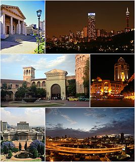
Johannesburg, informally known as Jozi or Joburg, is the largest city in South Africa and one of the 50 largest urban areas in the world. It is the provincial capital and largest city of Gauteng, which is the wealthiest province in South Africa. Johannesburg is the seat of the Constitutional Court. The city is located in the mineral-rich Witwatersrand range of hills and is the centre of large-scale gold and diamond trade, It was one of the host cities of the official tournament of the 2010 FIFA World Cup.

Gauteng is one of the nine provinces of South Africa. The name in Sotho-Tswana means "place of gold."
Centurion is an area with 236,580 (2011 Census) inhabitants in Gauteng Province of South Africa, located between Pretoria and Midrand (Johannesburg). Formerly an independent municipality, with its own town council, it has formed part of the City of Tshwane Metropolitan Municipality since 2000. Its heart is located at the intersection of the N1 and N14 freeways. The R21 also passes through Centurion.

Midrand is a municipality in central Gauteng Province, South Africa. It is situated in-between Centurion and Sandton, and is part of the City of Johannesburg Metropolitan Municipality.
The East Rand is the urban eastern part of the Witwatersrand that is functionally merged with the Johannesburg conurbation in South Africa. This area became settled by Europeans after a gold-bearing reef was discovered in 1886 and sparked the gold rush that gave rise to the establishment of Johannesburg.
Greater Johannesburg may mean:
Lenasia is a formerly racially segregated Indian township south of Soweto in Gauteng Province, South Africa. It is part of the City of Johannesburg Metropolitan Municipality. Lenasia is approximately 35 kilometres southwest of the Johannesburg central business district and 45 kilometres south of the Sandton central business district.

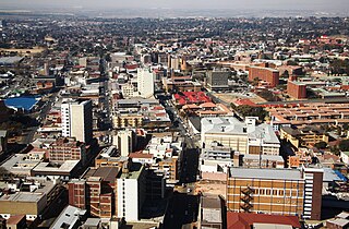
The suburbs of Johannesburg are officially demarcated areas within the city of Johannesburg, South Africa. As in other Commonwealth countries, the term suburb refers to a "neighbourhood", although the term has a somewhat stronger meaning in South Africa as most "suburbs" have legally recognised borders and often separate postal codes. The municipal functions for the area, such as municipal policing and social services, are still managed by the city government.
Edenvale is a town on the East Rand in Gauteng, South Africa. The greater Edenvale area has an estimated population of 70000, including Greenstone, Harmelia, Highway Gardens, Buurendal and Croydon. Modern Edenvale has become a very well known part of Ekurhuleni. It lies about halfway between the O.R. Tambo International Airport and the Johannesburg city centre and is located 12km by road from Sandton and about 9km from the closest Gautrain station.

Kempton Park is a main place of Ekurhuleni in the Gauteng province, South Africa. Kempton Park has been part of the City of Ekurhuleni Metropolitan Municipality since the year 2000. Kempton Park is located on the western city limits of Ekurhuleni and shares its administrative boundaries with Johannesburg, South Africa's largest city. It is situated south of Tembisa, one of the largest townships in South Africa, which is also integrated into Ekurhuleni. The name of the city is sometimes written as "Kemptonpark" in Afrikaans.

The R24 is a major East-West provincial route in the Gauteng and North West provinces that links OR Tambo International Airport with Rustenburg via Johannesburg, Krugersdorp and Magaliesburg. The process of renaming the streets and freeway that form the route from Krugersdorp eastward to OR Tambo International after anti-apartheid stalwart Albertina Sisulu was completed in 2013.

The R25 is a provincial route in South Africa that connects Johannesburg with Groblersdal via Kempton Park, Bapsfontein and Bronkhorstspruit.
Ivory Park is a densely populated residential area in the east of Johannesburg, in the Gauteng province of South Africa. It is located in Region 2.

The City of Johannesburg Metropolitan Municipality is a metropolitan municipality that manages the local governance of Johannesburg, South Africa. It is divided into several branches and departments in order to expedite services for the city.

The City of Ekurhuleni Metropolitan Municipality is a metropolitan municipality that forms the local government of the East Rand region of Gauteng, South Africa. The name Ekurhuleni means place of peace in XiTsonga. Ekurhuleni is one of the five districts of Gauteng province and one of the eight metropolitan municipalities of South Africa. The seat of Ekurhuleni is Germiston. The most common native language spoken by its 3.17 million people is IsiZulu, as of the 2001 Census. OR Tambo International Airport falls in the Kempton Park area of Ekurhuleni.
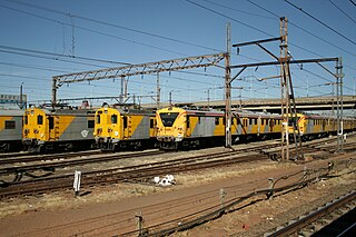
Metrorail Gauteng is a network of commuter rail services in Gauteng province in South Africa, serving the Johannesburg and Pretoria metro areas. It is operated by Metrorail, a division of the Passenger Rail Agency of South Africa (PRASA).
The 2016 Johannesburg flood was a natural disaster in South Africa that took place on 9 November 2016. The flooding, which occurred in the area east of Johannesburg, affected both Johannesburg and Ekurhuleni. The storm and flash floods caused significant damage to the township of Alexandra, while the suburb of Buccleuch was declared a disaster area. The flooding was caused by a significant cloud burst from a convective system.
Taal-Net Group of Schools is consortium of co-educational, selective day and boarding schools which encompasses pre-schools, primary schools, secondary schools, and Further Education and Training Colleges. The schools are situated in South Africa and Zimbabwe. The schools are registered with Department of Education in South Africa, UMALUSI, Department of High Education in South Africa and Ministry of Education and Child Welfare in Zimbabwe.


