Thanbaya

Last updated
Thanbaya
Village
Myanmar location map.svg
Red pog.svg
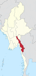
Thanbaya
Location in Burma
Coordinates: 23°07′27″N94°25′37″E / 23.1243°N 94.4269°E / 23.1243; 94.4269 Coordinates: 23°07′27″N94°25′37″E / 23.1243°N 94.4269°E / 23.1243; 94.4269
Country Flag of Myanmar.svg  Burma
Region Sagaing Region
District Kale District
Township Kalewa Township
Time zone UTC+6.30 (MST)

Thanbaya (also: Tanbaya) is a village in Kalewa Township, Kale District, in the Sagaing Region of western Burma. [1]

Related Research Articles

Kalewa Township Township in Sagaing Region, Burma

Kalewa Township is a township of Kale District in Sagaing Division of Burma (Myanmar). The principal town and administrative seat is Kalewa. The Paluzawa coal mines are located in Kalewa township.

Kayin State State of Myanmar

Kayin State, also known by the endonyms Kawthoolei and Karen State, is a state of Myanmar. The capital city is Hpa-An, also spelled Pa-An.

Than Pu Yar Village in Kayin State, Myanmar

Than Pu Yar or Thanbaya(Burmese: သံပုရာ) is a village tract of Kyain Seikgyi Township, Kawkareik District, in Kayin State, Myanmar (Burma). In 2014 it had a total population of 4,172 people. The village tract contains 2 villages.

References

  1. "Thanbaya (approved)". GEOnet Names Server, United States National Geospatial-Intelligence Agency. Retrieved 31 January 2022.