Thomas Creek (Linn County, Oregon)

Last updated
Thomas Creek
Hannah Bridge (7434073450).jpg
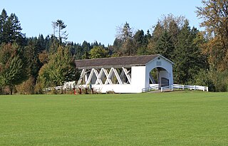
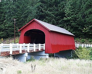
Hannah Bridge over Thomas Creek
USA Oregon location map.svg
Red pog.svg
Location of the mouth of Thomas Creek in Oregon
Etymology19th-century settler Frederick Thomas [1] [2]
Location
Country United States
State Oregon
County Linn County
Physical characteristics
Source Willamette National Forest
 - locationsouthwest of Detroit Lake
 - coordinates 44°39′59″N122°18′54″W / 44.66639°N 122.31500°W / 44.66639; -122.31500 [1]
 - elevation3,734 ft (1,138 m) [3]
Mouth South Santiam River
 - locationwest of Scio
 - coordinates 44°40′39″N122°58′19″W / 44.67750°N 122.97194°W / 44.67750; -122.97194 Coordinates: 44°40′39″N122°58′19″W / 44.67750°N 122.97194°W / 44.67750; -122.97194 [1]
Length35 mi (56 km) [4]
Discharge 
 - location Scio, Oregon [5]
 - minimum3.4 cu ft/s (0.096 m3/s)
 - average487 cu ft/s (13.8 m3/s) [5]
 - maximum27,400 cu ft/s (780 m3/s)
Basin features
Basin size117 sq mi (300 km2) [6]

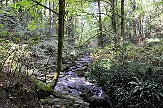
Thomas Creek is a stream, about 35 miles (56 km) long, in Linn County in the U.S. state of Oregon. Beginning in Willamette National Forest on the western slopes of the Cascade Range, the creek flows generally west through Santiam State Forest and farmland to meet the South Santiam River west of Scio. [7]

Linn County, Oregon county in Oregon, USA

Linn County is a county located in the U.S. state of Oregon. As of the 2010 census, the population was 116,672. The county seat is Albany. The county is named in honor of Lewis F. Linn, a U.S. Senator from Missouri who advocated the American settlement of the Oregon Country.

U.S. state constituent political entity of the United States

In the United States, a state is a constituent political entity, of which there are currently 50. Bound together in a political union, each state holds governmental jurisdiction over a separate and defined geographic territory and shares its sovereignty with the federal government. Due to this shared sovereignty, Americans are citizens both of the federal republic and of the state in which they reside. State citizenship and residency are flexible, and no government approval is required to move between states, except for persons restricted by certain types of court orders. Four states use the term commonwealth rather than state in their full official names.

Oregon State of the United States of America

Oregon is a state in the Pacific Northwest region on the West Coast of the United States. The Columbia River delineates much of Oregon's northern boundary with Washington, while the Snake River delineates much of its eastern boundary with Idaho. The parallel 42° north delineates the southern boundary with California and Nevada. Oregon is one of only three states of the contiguous United States to have a coastline on the Pacific Ocean.

Contents

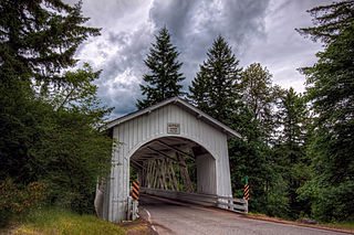
Three covered bridges, all listed on the National Register of Historic Places, carry traffic over the creek. Two other covered bridges that originally crossed Thomas Creek were moved to parks in cities outside the creek's watershed. Several covered bridges that once spanned the creek were destroyed in weather-related incidents or were otherwise demolished.

Covered bridge wooden bridge with protective cover

A covered bridge is a timber-truss bridge with a roof, decking, and siding which, in most covered bridges, create an almost complete enclosure. The purpose of the covering is to protect the wooden structural members from the weather. Uncovered wooden bridges typically have a lifespan of only 20 years because of the effects of rain and sun, but a covered bridge could last 100 years.

National Register of Historic Places federal list of historic sites in the United States

The National Register of Historic Places (NRHP) is the United States federal government's official list of districts, sites, buildings, structures, and objects deemed worthy of preservation for their historical significance. A property listed in the National Register, or located within a National Register Historic District, may qualify for tax incentives derived from the total value of expenses incurred preserving the property.

The creek at times has flooded Scio, particularly in 1964. The drop in elevation on its upper reaches, coupled with its flow volume, make it suitable at times for whitewater canoes and kayaks. The stream supports populations of smallmouth bass, cutthroat trout, and other fish.

Whitewater bubbly, or aerated and unstable current

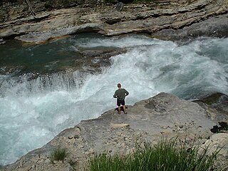
Whitewater is formed in a rapid, when a river's gradient increases enough to generate so much turbulence that air is entrained into the water body, that is, it forms a bubbly or aerated and unstable current; the frothy water appears white. The term is also loosely used to refer to less turbulent, but still agitated, flows.

Smallmouth bass species of fish

The smallmouth bass is a species of freshwater fish in the sunfish family (Centrarchidae) of the order Perciformes. It is the type species of its genus. One of the black basses, it is a popular game fish sought by anglers throughout the temperate zones of North America, and has been spread by stocking—as well as illegal introductions—to many cool-water tributaries and lakes in Canada and more so introduced in the United States. The maximum recorded size is approximately 27 inches and 12 pounds. The smallmouth bass is native to the upper and middle Mississippi River basin, the Saint Lawrence River–Great Lakes system, and up into the Hudson Bay basin. Its common names include smallmouth, bronzeback, brown bass, brownie, smallie, bronze bass, and bareback bass.

Cutthroat trout species of fish

The cutthroat trout(Oncorhynchus clarkii) is a fish species of the family Salmonidae native to cold-water tributaries of the Pacific Ocean, Rocky Mountains, and Great Basin in North America. As a member of the genus Oncorhynchus, it is one of the Pacific trout, a group that includes the widely distributed rainbow trout. Cutthroat trout are popular gamefish, especially among anglers who enjoy fly fishing. The common name "cutthroat" refers to the distinctive red coloration on the underside of the lower jaw. The specific name clarkii was given to honor explorer William Clark, coleader of the Lewis and Clark Expedition.

Course

Thomas Creek is a tributary of the South Santiam River. It begins on the western slopes of the Cascade Range at an elevation of about 3,700 feet (1,100 m) above sea level southwest of Detroit Lake, which is on the North Santiam River. The creek flows generally west from its source, receiving Hall and other small creeks before reaching the unincorporated community of Jordan. Jordan Creek enters from the right at about river mile (RM) 19. [8]

Cascade Range mountain range in western North America

The Cascade Range or Cascades is a major mountain range of western North America, extending from southern British Columbia through Washington and Oregon to Northern California. It includes both non-volcanic mountains, such as the North Cascades, and the notable volcanoes known as the High Cascades. The small part of the range in British Columbia is referred to as the Canadian Cascades or, locally, as the Cascade Mountains. The latter term is also sometimes used by Washington residents to refer to the Washington section of the Cascades in addition to North Cascades, the more usual U.S. term, as in North Cascades National Park. The highest peak in the range is Mount Rainier in Washington at 14,411 feet (4,392 m).

Detroit Lake reservoir in Oregon, United States

Detroit Lake is a reservoir impounded by the Detroit Dam on the North Santiam River 46 miles (74 km) southeast of Salem, Oregon, United States. The lake is adjacent to Oregon Route 22 near the city of Detroit. This mesotrophic lake stores water for use by the city of Salem and other nearby communities.

North Santiam River river in the United States of America

The North Santiam River is a 92-mile (148 km) tributary of the Santiam River in western Oregon in the United States. It drains 766 square miles (1,980 km2) of the Cascade Range on the eastern side of the Willamette Valley east of Salem.

Downstream of Jordan, other small tributaries enter before Thomas Creek flows by a stream gauge operated by the United States Geological Survey at RM 14.2. [5] The creek then passes under Oregon Route 226 before reaching Scio. Below Scio, the creek receives Sucker Slough before entering the South Santiam River about 3 miles (5 km) above its confluence with the North Santiam River. The North and South Santiam combine to form the Santiam River, a tributary of the Willamette River. [8]

Stream gauge locations used to monitor surface water flow

A stream gauge, streamgage or gauging station is a location used by hydrologists or environmental scientists to monitor and test terrestrial bodies of water. Hydrometric measurements of water level surface elevation ("stage") and/or volumetric discharge (flow) are generally taken and observations of biota and water quality may also be made. The location of gauging stations are often found on topographical maps. Some gauging stations are highly automated and may include telemetry capability transmitted to a central data logging facility.

United States Geological Survey scientific agency of the United States government

The United States Geological Survey is a scientific agency of the United States government. The scientists of the USGS study the landscape of the United States, its natural resources, and the natural hazards that threaten it. The organization has four major science disciplines, concerning biology, geography, geology, and hydrology. The USGS is a fact-finding research organization with no regulatory responsibility.

Oregon Route 226 highway in Oregon

Oregon Route 226 is an Oregon state highway that runs between a point east of Albany in the Willamette Valley, and the town of Mehama along the Santiam River. The highway is also known as the Albany-Lyons Highway No. 211, and is 26 miles (42 km) long. It lies entirely within Linn County, except for the very northernmost segment in Mehama, which is in Marion County.

Discharge

Based on data collected from 1962 to 1987 and from 2002 to 2013, the average discharge of Thomas Creek at the stream gauge near Scio was 487 cubic feet per second (13.8 m3/s). During those years, the maximum discharge of 27,400 cubic feet per second (780 m3/s) occurred on December 22, 1964, and the minimum of 3.4 cubic feet per second (0.096 m3/s) occurred on September 6, 2003. The basin size above the gauge is about 110 square miles (280 km2), or about 94 percent of the whole basin. [5]

Floods

The entire city of Scio lies in a floodplain with a 1 percent annual chance of a flood. [9] All of Scio was flooded in December 1964, when Thomas Creek and Peters Ditch overflowed their banks. The flooding was generally shallow except near the creek, where it reached 3 feet (1 m) in depth. [10] A flood of this size along the creek is expected, on average, only once in 200 years. [10] The inundation was part of a state-wide series of floods known as the Christmas flood of 1964, rated by the National Weather Service as one of Oregon's top 10 weather events of the 20th century. [11] In January 1972, Scio was flooded again when the discharge at the gauge reached 20,200 cubic feet per second (570 m3/s). [12]

Covered bridges

Gilkey Bridge carries Goar Road over Thomas Creek downstream from Scio. Gilkey Bridge (7332313808).jpg
Gilkey Bridge carries Goar Road over Thomas Creek downstream from Scio.

Several covered bridges have spanned Thomas Creek since the late 19th century, some of them replacements for damaged or demolished bridges at the same spots. [13] Three of these bridges—Gilkey, Shimanek, and Hannah—still cross the creek, while two—Weddle and Jordan—have been moved to cities outside the Thomas Creek watershed. [13] The three that still cross the creek are on the National Register of Historic Places (NRHP). [14] [15] [16] The Weddle Bridge was listed on the NRHP in 1979 but delisted in 1991 after its move to Sweet Home. [17]

At roughly 5 miles (8 km) upstream of the creek mouth, Gilkey Bridge and a covered railroad bridge next to it crossed the creek at the former community of Gilkey and its Gilkey Station along the tracks of the Southern Pacific Railroad. [18] The road bridge, a 120-foot (37 m) structure of the Howe truss type, was built in 1939, damaged and closed in 1997, repaired and re-opened in 1998. [18] The companion railroad bridge, a 125-foot (38 m) Howe truss span, was removed in 1962. [13] The Gilkey Covered Bridge carries Goar Road over the creek. [7]

The Weddle Bridge, which replaced an earlier covered bridge at the same site, once crossed Thomas Creek near Scio, at about RM 9. [13] [19] A Howe truss span of 120 feet (37 m), it was built in 1937. In the late 1980s, the deteriorating structure, no longer in use, was scheduled for destruction. Efforts to save it led the Oregon Legislative Assembly to create the Oregon Covered Bridge Program, aimed at preserving the state's covered bridges. Weddle Bridge was the first bridge to win a grant from the program. In 1989, a group in Sweet Home raised additional funds to have the bridge moved and installed across Ames Creek in that city's Sankey Park. [19]

Shimanek Bridge near Scio carries Richardson Gap Road. Shimanek Bridge, Scio, OR (6563854857).jpg
Shimanek Bridge near Scio carries Richardson Gap Road.

Shimanek Bridge, upstream of Scio at about RM 12, is a 130-foot (40 m) Howe truss structure built in 1966. It is the newest and longest covered bridge in Linn County. At least four other covered bridges crossed Thomas Creek at this same spot, the first documented one in 1891. Storms and floods damaged the earlier bridges. [20] The Shimanek Bridge carries Richardson Gap Road over the creek. [7]

About 1.5 miles (2.4 km) downstream of Jordan, near RM 17, the Hannah Bridge crosses the creek. Built in 1936, it is 105 feet (32 m) long and of the Howe truss type. Another covered bridge, built in 1912, is thought to have crossed the creek slightly upstream of the Hannah Bridge but was torn down and its lumber used in farm buildings. [21] Burmester Creek Road crosses the Hannah Bridge. [14]

The Jordan Bridge, built in 1937 at about RM 19, was a 90-foot (27 m) Howe truss span. Dismantled in 1985, its timbers were moved to Stayton and reassembled in that city's Pioneer Park. Destroyed by fire in 1994, it was rebuilt in the park in 1998. [13]

Recreation

The creek supports populations of smallmouth bass and cutthroat trout as well as small runs of Chinook salmon and steelhead. The stream is closed to fishing for salmon and steelhead, but anglers can fish for bass, and catch-and-release fishing for trout is allowed. [4]

Whitewater enthusiasts sometimes run a 5-mile (8 km) segment of the upper creek from Hall Creek to 5-Mile Bridge. This stretch is rated 3 (intermediate) to 4 (advanced) on the International Scale of River Difficulty. Hazards include fast water, rocky ledges, submerged or floating logs, a "nasty chute", and a debris dam. [22]

The next 9.5 miles (15.3 km), from 5-Mile Bridge to Hannah Bridge is also run. It is rated class 2+ or class 3, depending on the flow volume, and at least one portage is required. Hazards include overhanging brush under which the current may sweep a canoe or kayak. [22]

See also

Related Research Articles

Sweet Home, Oregon City in Oregon, United States

Sweet Home is a city in Linn County, Oregon, United States. The population was 8,925 at the 2010 census. According to the city, "Sweet Home is sometimes referred to as the 'Gateway to the Santiam Playground' due to its proximity to nearby lakes, rivers and the Cascade Mountains."

Jordan, Oregon Unincorporated community in Oregon, United States

Jordan is an unincorporated community in Linn County, in the U.S. state of Oregon. It lies along Oregon Route 226, southeast of Stayton and about halfway between Scio and Lyons.

Butte Creek (Oregon)

Butte Creek is a stream in the U.S. state of Oregon, a tributary of the Pudding River. It is approximately 33 miles (53 km) long and, for all of its course, defines part of the northeastern boundary of Marion County and the southern boundary of Clackamas County.

Tryon Creek tributary of the Willamette River in Oregon

Tryon Creek is a 4.85-mile (7.81 km) tributary of the Willamette River in the U.S. state of Oregon. Part of the drainage basin of the Columbia River, its watershed covers about 6.5 square miles (16.8 km2) in Multnomah and Clackamas counties. The stream flows southeast from the Tualatin Mountains through the Multnomah Village neighborhood of Portland and the Tryon Creek State Natural Area to the Willamette in the city of Lake Oswego. Parks and open spaces cover about 21 percent of the watershed, while single-family homes dominate most of the remainder. The largest of the parks is the state natural area, which straddles the border between the two cities and counties.

Mill Creek (Marion County, Oregon) tributary of the Willamette River draining parts of Marion County, Oregon, USA

Mill Creek is a 26-mile (42 km) tributary of the Willamette River that drains a 111-square-mile (290 km2) area of Marion County in the U.S. state of Oregon. Flowing generally west from its source south of Silver Falls State Park, it passes through the cities of Aumsville, Stayton, Sublimity, and Turner before emptying into the Willamette in Salem.

Quartzville Creek tributary of the Middle Santiam River in Oregon

Quartzville Creek is a 28-mile (45 km) tributary of the Middle Santiam River in Linn County in the U.S. state of Oregon. It is paralleled by the Quartzville Back Country Byway and used for recreation, including camping, fishing, hunting, kayaking, and gold panning. The lower 12 miles (19 km) of the creek, from the Willamette National Forest boundary to Green Peter Reservoir, was designated Wild and Scenic in 1988.

Stewart Bridge (Walden, Oregon)

Stewart Bridge is a Howe truss covered bridge built in 1930 near Walden, Oregon, United States, in Lane County. It was listed on the National Register of Historic Places in 1979. It is 60 feet (18 m) long and crosses Mosby Creek, a tributary of the Row River.

Course of the Rogue River (Oregon) river in the United States of America

The Rogue River in the U.S. state of Oregon begins at Boundary Springs on the border between Klamath and Douglas counties near the northern edge of Crater Lake National Park. The Rogue River flows generally west for 215 miles (346 km) from the Cascade Range through the Rogue River – Siskiyou National Forest and the Klamath Mountains to the Pacific Ocean at Gold Beach. Communities along its course include Union Creek, Prospect, Trail, Shady Cove, Gold Hill, and Rogue River, all in Jackson County; Grants Pass, and Galice in Josephine County, and Agness, Wedderburn and Gold Beach in Curry County. Significant tributaries include the South Fork Rogue River, Elk Creek, Bear Creek, the Applegate River, and the Illinois River. Arising at 5,320 feet (1,622 m) above sea level, the river loses more than 1 mile (1.6 km) in elevation by the time it reaches the Pacific.

Hayden Bridge historic covered bridge in Oregon, USA

Hayden Bridge, a Howe truss structure, spans the Alsea River about 2 miles (3 km) west of Alsea, Oregon, United States. Constructed in 1918, the 91-foot (28 m) span is one of only seven remaining covered bridges in Oregon that were built before 1920. Similar spans such as the Mill Creek Bridge crossed the Alsea or one of its tributaries in the same vicinity, but only the Hayden Bridge has survived. It was added to the National Register of Historic Places in 1979.

Course of the Willamette River

The Willamette River is a 187-mile (301 km) tributary of the Columbia River in the U.S. state of Oregon. The upper tributaries of the Willamette originate in mountains south and southeast of Eugene and Springfield. Formed by the confluence of the Middle Fork Willamette River and Coast Fork Willamette River near Springfield, the main stem meanders generally north from source to mouth. The river's two most significant course deviations occur at Newberg, where the stream turns sharply east, and about 18 miles (29 km) downriver from Newberg, where it turns north again. Near its mouth, the river splits into two channels that flow around Sauvie Island. The main channel enters the Columbia about 101 miles (163 km) from the larger stream's mouth on the Pacific Ocean, and the smaller Multnomah Channel enters the Columbia about 14.5 miles (23.3 km) further downstream near St. Helens in Columbia County.

Weddle Bridge

The Weddle Bridge is a 120-foot (37 m) long wooden covered bridge in Sweet Home, Oregon, United States. The bridge originally spanned Thomas Creek near Scio but was replaced by a concrete bridge in 1980 and was scheduled to be destroyed in 1987. To save the bridge, local activists staged protests and persuaded former Oregon Senator Mae Yih to help save the bridge. The Oregon Legislative Assembly soon approved the Oregon Covered Bridge Program, which helped pay for covered bridge rehabilitation projects statewide. The Weddle Bridge was the first to receive grants from the program.

Short Bridge

The Short Bridge spans the South Santiam River 12 miles east of Sweet Home, Oregon near the community of Cascadia. The 105-foot Howe truss type bridge was built in 1945. It is named for Gordon Short, a long-time area resident. The bridge is listed on the National Register of Historic Places.

Elliott Corbett Memorial State Recreation Site

Elliott Corbett Memorial State Recreation Site is a state park along the south shore of Blue Lake Crater in Jefferson County, Oregon, United States. The park is named in honor of Elliott R. Corbett II, who was killed while serving in the United States Army during World War II. It includes 63 acres (25 ha) of wilderness land with very few park facilities. Corbett State Park is administered by the Oregon Parks and Recreation Department.

Crabtree Creek (South Santiam River tributary)

Crabtree Creek is a tributary of the South Santiam River in Linn County in the U.S. state of Oregon. It begins in the western foothills of the Cascade Range at Crabtree Mountain near Crabtree Lake. From there it flows generally west to meet the larger stream about 3 miles (5 km) upstream of where the South Santiam merges with the North Santiam River to form the Santiam River.

Shimanek Bridge

The Shimanek Bridge is a covered bridge near Scio in Linn County in the U.S. state of Oregon. It was added to the National Register of Historic Places as Thomas Creek – Shimanek Covered Bridge in 1987.

Gilkey Bridge covered bridge in Linn County in the U.S. state of Oregon

The Gilkey Bridge is a covered bridge in Linn County in the U.S. state of Oregon. It was added to the National Register of Historic Places as Thomas Creek – Gilkey Covered Bridge in 1987.

Hannah Bridge covered bridge in Linn County in the U.S. state of Oregon

The Hannah Bridge is a covered bridge in Linn County in the U.S. state of Oregon. It was added to the National Register of Historic Places as Hannah Bridge in 1979.

Fisher School Bridge

The Fisher School Bridge is a covered bridge in Lincoln County in the U.S. state of Oregon. The 72-foot (22 m) Howe truss structure crosses a stream called Five Rivers near the rural community of Fisher in the Central Oregon Coast Range. Closed to vehicles, it is a pedestrian bridge.

Ames Creek (South Santiam River) small tributary of the South Santiam River in the U.S. state of Oregon

Ames Creek is a small tributary of the South Santiam River in the U.S. state of Oregon. It begins near Chimney Rock in the foothills of the Cascade Range in Linn County. It flows northwest to meet the river at Sweet Home, about 33 miles (53 km) by river from the South Santiam's confluence with the Santiam River. Ames Creek passes under U.S. Route 20 just before entering the river.

References

  1. 1 2 3 "Thomas Creek". Geographic Names Information System. United States Geological Survey. November 28, 1980. Retrieved November 30, 2014.
  2. "Historical scrapbook". The Times. Mar 10, 1966. p. 4. Retrieved 29 October 2015.
  3. Source elevation derived from Google Earth using GNIS coordinates.
  4. 1 2 Sheehan, Madelynne Diness (2005). Fishing in Oregon (10th ed.). Scappoose, Oregon: Flying Pencil Publications. p. 179. ISBN   0-916473-15-5.
  5. 1 2 3 4 "Water-Data Report 2013: 14188800 Thomas Creek Near Scio, OR" (PDF). United States Geological Survey. Retrieved December 1, 2014.
  6. "Thomas Creek Watershed Analysis" (PDF). Bureau of Land Management. p. 14. Retrieved November 30, 2014.
  7. 1 2 3 Oregon Road and Recreation Atlas (5th ed.). Santa Barbara, California: Benchmark Maps. 2012. pp. 48–49, 60–61. ISBN   978-0-929591-62-9.
  8. 1 2 United States Geological Survey (USGS). "United States Geological Survey Topographic Map". TopoQuest. Retrieved December 1, 2014. The map includes river-mile markers as far upstream as the confluence with Hall Creek, 32 miles (51 km) from the mouth.
  9. FEMA, p. 11
  10. 1 2 FEMA, p. 14
  11. "Oregon's Top 10 Weather Events of 1900s". National Weather Service. Retrieved December 1, 2014.
  12. FEMA, p. 17
  13. 1 2 3 4 5 Cockrell, Bill (2008). Images of America: Oregon's Covered Bridges. Charleston, South Carolina: Arcadia Publishing. pp. 112–16. ISBN   978-0-7385-5818-9.
  14. 1 2 "Hannah Bridge". Oregon Historic Sites Database. Oregon Parks and Recreation Department. Retrieved December 1, 2014.
  15. "Shimanek Bridge". Oregon Historic Sites Database. Oregon Parks and Recreation Department. Retrieved December 1, 2014.
  16. "Gilkey Bridge". Oregon Historic Sites Database. Oregon Parks and Recreation Department. Retrieved December 1, 2014.
  17. "Weddle Bridge". Oregon Historic Sites Database. Oregon Parks and Recreation Department. Retrieved December 1, 2014.
  18. 1 2 "Thomas Creek (Gilkey) Covered Bridge" (PDF). Oregon Department of Transportation. Retrieved November 30, 2014.
  19. 1 2 "Ames Creek (Weddle) Covered Bridge" (PDF). Oregon Department of Transportation. Retrieved November 30, 2014.
  20. "Thomas Creek (Shimanek) Covered Bridge" (PDF). Oregon Department of Transportation. Retrieved November 30, 2014.
  21. "Thomas Creek (Hannah) Covered Bridge" (PDF). Oregon Department of Transportation. Retrieved November 30, 2014.
  22. 1 2 Giordano, Pete. Soggy Sneakers: A Paddler's Guide to Oregon's Rivers (4th ed.). Seattle, Washington: The Mountaineers Press. pp. 178–80. ISBN   978-0-89886-815-9.

Works cited