
Scio is a city in Linn County, Oregon, United States. Located east of Jefferson and south of Stayton, it sits along Oregon Route 226 near the confluence of the north and south forks of the Santiam River. Incorporated in 1866, the population was 956 at the 2020 census.

This is a list of properties and historic districts in Oregon that are listed on the National Register of Historic Places. There are listings in all of Oregon's 36 counties.
The Sonestown Covered Bridge is a covered bridge over Muncy Creek in Davidson Township, Sullivan County, Pennsylvania built around 1850. It is 110 ft (34 m) long and was placed on the National Register of Historic Places (NRHP) in 1980. It is named for the nearby unincorporated village of Sonestown in Davidson Township, and is also known as the Davidson Covered Bridge. It was built to provide access to a grist mill which operated until the early 20th century.
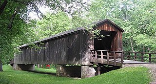
Locust Creek Covered Bridge State Historic Site is a publicly owned property in Linn County, Missouri, maintained as a state historic site by the Missouri Department of Natural Resources. Also called the Linn County Bridge, the covered bridge is located about 3 miles (4.8 km) east of Meadville, Missouri. At a length of 151 feet (46 m) with a width of 16 ft 8 in (5.08 m) it is the longest of the four remaining covered bridges in the state of Missouri. It was listed on the National Register of Historic Places in 1970.

The Union Covered Bridge State Historic Site is a Missouri State Historic Site in Monroe County, Missouri. The covered bridge is a Burr-arch truss structure built in 1871 over the Elk Fork of the Salt River. It was almost lost to neglect in the 1960s, but was added to the state park system in 1967, the same year it was damaged by a flood. Repairs were made the next year, using timbers salvaged from another covered bridge that had been destroyed by the same flood. In 1970, it was closed to vehicular traffic and was added to the National Register of Historic Places. Further repairs were made in 1988, and it survived the Great Flood of 1993, only to be damaged by another flood in 2008 and later re-repaired. It is about 120 feet (37 m) or 125 feet (38 m) long, 12 feet (3.7 m) high, and 17.5 feet (5.3 m) wide.

Unity Bridge is an historic 90-foot (27 m) long covered bridge over Fall Creek at Unity near Lowell in Lane County, Oregon, United States. Also known as Unity Covered Bridge and Unity Creek Bridge, it was built in 1936 at a cost $4,400 by Lane County using the Howe truss system. Its east side features a full-length window with its own roof so that drivers can see oncoming cars.

Ashland Covered Bridge, also known as Ashland Bridge or Barley Mill Road Covered Bridge, is a covered bridge over Red Clay Creek on Barley Mill Road in Ashland in New Castle County, Delaware. It was added to the National Register of Historic Places in 1973.
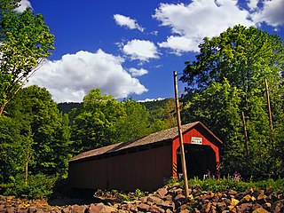
The Weddle Bridge is a 120-foot (37 m) long wooden covered bridge in Sweet Home, Oregon, United States. The bridge originally spanned Thomas Creek near Scio but was replaced by a concrete bridge in 1980 and was scheduled to be destroyed in 1987. To save the bridge, local activists staged protests and persuaded former Oregon Senator Mae Yih to help save the bridge. The Oregon Legislative Assembly soon approved the Oregon Covered Bridge Program, which helped pay for covered bridge rehabilitation projects statewide. The Weddle Bridge was the first to receive grants from the program.
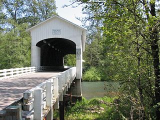
The Pengra Bridge is a covered bridge near Jasper in the U.S. state of Oregon. The 120-foot (37 m) Howe truss structure carries Place Road over Fall Creek in Lane County. It replaced an earlier bridge, built in 1904, that crossed the creek a few feet further upstream.
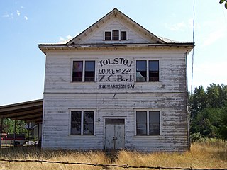
The Z.C.B.J. Tolstoj Lodge No. 224, also known as Bohemian Hall or Tolstoj Sokol Lodge, is a historic building in rural Linn County southeast of Scio, Oregon, United States, that was built in 1911. It was listed on the National Register of Historic Places on September 14, 1995. It historically served as a meeting hall for the Czech community. The lodge organized a Czech school, in addition to hosting concerts, dances, Sokol events and Fourth of July celebrations.

The Delhi Bridge, also known as the East Delhi Bridge, is a one-lane, wrought iron Pratt through truss bridge that carries East Delhi Road over the Huron River in Scio Township, Michigan. The bridge was completed on October 12, 1883 to replace a wooden span built in 1851. In 1917, the bridge was severely damaged by a tornado but was rebuilt. After it was closed to traffic in 2005 for being unsafe, the bridge was renovated and reopened in 2009. The bridge is listed on the National Register of Historic Places.
Thomas Creek is a stream, about 35 miles (56 km) long, in Linn County in the U.S. state of Oregon. Beginning in Willamette National Forest on the western slopes of the Cascade Range, the creek flows generally west through Santiam State Forest and farmland to meet the South Santiam River west of Scio.

The Larwood Bridge is a covered bridge near Lacomb in Linn County in the U.S. state of Oregon. It was added to the National Register of Historic Places in 1979.

The Gilkey Bridge is a covered bridge in Linn County in the U.S. state of Oregon. It was added to the National Register of Historic Places as Thomas Creek – Gilkey Covered Bridge in 1987.
The Hannah Bridge is a covered bridge in Linn County in the U.S. state of Oregon. It was added to the National Register of Historic Places as Hannah Bridge in 1979.

The Grave Creek Bridge is a covered bridge in Josephine County in the U.S. state of Oregon. It carries Sunny Valley Loop Road over Grave Creek about 15 miles (24 km) north of Grants Pass and within sight of Interstate 5 (I-5).

The Drift Creek Bridge is a covered bridge in Lincoln County in the U.S. state of Oregon. Built in 1914, the structure originally carried Drift Creek County Road over Drift Creek. The creek flows into Siletz Bay of the Pacific Ocean south of Lincoln City.

The Wimer Bridge is a covered bridge over Evans Creek in Jackson County in the U.S. state of Oregon. The version that was listed on the National Register of Historic Places, was built in 1927. This structure, 85 feet (26 m) long, carried East Evans Creek County Road over the creek in the rural community of Wimer. The creek is a tributary of the Rogue River, which it joins at the small city of Rogue River.

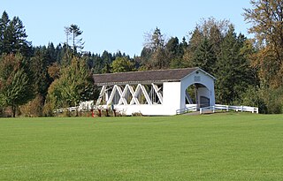
Stayton–Jordan Bridge is a covered bridge in Stayton in Marion County in the U.S. state of Oregon. Built in 1998, it carries foot traffic over the Salem Power Canal in Pioneer Park. The canal is a diversion from the North Santiam River.


