Thorapadi, Vellore

Last updated

Thorapadi
Neighbourhood
India Tamil Nadu location map.svg
Red pog.svg
Thorapadi
Location in Tamil Nadu, India
Coordinates: 12°56′N79°08′E / 12.93°N 79.13°E / 12.93; 79.13 Coordinates: 12°56′N79°08′E / 12.93°N 79.13°E / 12.93; 79.13
CountryFlag of India.svg  India
State Tamil Nadu
District Vellore District
Talukas Vellore
Government
  Body Vellore Municipal Corporation
  MayorMrs. P. Karthiyayini
Languages
  Official Tamil
Time zone UTC+5:30 (IST)
PIN
632002
Telephone code91 416
Vehicle registration TN 23
Lok Sabha constituencyVellore
Vidhan Sabha constituencyVellore
Civic agency Vellore Municipal Corporation

Thorapadi is a part of Vellore Corporation. It is a prominent area in the city of Vellore.

Contents

Thorapadi is well known for its Vellore Central Prison, Academy of Prisons and Correctional Administration (APCA), Warder's Training Institute, Women's Jail, Christian Medical College (ranked one of the two best Medical Colleges of India by India Today), Parade Grounds and Thanthai Periyar Govt. Engineering College and Polytechnic - a prestigious institute for technical studies run by the Government of Tamil Nadu. Thorapadi is 7 km from Katpadi Junction Railway Station, 4 km from old bus terminus (FORT), 5 km from new bus terminus (GREEN CIRCLE) and 3 km from Cantonment Railway Station.

Geography

Thorapadi is located at 12.93° N 79.13° E. It has an average elevation of 216 metres (708 feet). It is surrounded by Sripuram in the south, Allapuram in the north, Otteri-Bagayam in the east and Great Thorapadi Lake in the west.

Ram Chandrasekaran a native of this place informs that there is no recorded history for the name reference for Thorapadi. Padi is the common name for residential areas in Agricultural adjoining Hilly areas (cf: Hindi/Sanskrit Pahad meaning Hill) and that is why we find many villages having suffix 'padi' in Tamil Land viz.Velapadi, Katpadi etc. Thorapadi would have derived its name from Thiru Padi and now corrupted to form Thorapadi. Thiru is a common name for almost all towns and cities in Tamil Nadu viz. Thiruvannamalai, Thirupattur and there are so many places starting with Prefix Thiru meaning 'the blessed'. The prominence of the place can be traced back to Britishers establishing a Central Prison during the 1800s.

Demographics

As of 2001 India census, [1] Thorapadi had a population of 14,292. Males constitute 54% of the population and females 46%. Thorapadi has an average literacy rate of 74%, higher than the national average of 59.5%: male literacy is 79%, and female literacy is 67%. In Thorapadi, 7% of the population is under 6 years of age. Tamil is the official language which is spoken as a native language and English is widely understood.

Neighborhoods

Thorapadi can be subdivided into crowded north and relatively well planned south.

Azad Road is the arterial road of Thorapadi. Other important roads are Nethaji Street, Jail Road, Usur Road, CMC-Thanthai Periyar College Road (Hill Road), Pillayar Koil Street (derives its name from the Pillayar temple located at the far end of the street) and Periya Theru (big street).

Mosque Street and Janda Street is a collection of densely populated streets with predominantly muslim population.

(see Wikipedia: Kamaraj Nagar)
Kamaraj Nagar (Tamil: காமராஜ் நகர்) in southern Thorapadi, is primarily a residential neighbourhood of mainly posh dwellings, which is cool and greenery with concrete roads. It is one of the rapid developing parts of the city of Vellore. The area is named after the late chief minister of Tamil Nadu, Kamaraj. A Government higher secondary school, Vellore Central Prison, a Badminton Training School and a Theatre make Kamaraj Nagar unique in Thorapadi. Also, it is the center of local cricketing events, thanks to a huge sports (though undeveloped) ground located within Government Higher Secondary School (no fancier of local cricket can forget Kamaraj Nagar Cricket Club's breath taking victory over Punthottam Cricket Team in the finals of Millennium tournament here in 2000).

In addition to being a residential area, Kamaraj Nagar has become a busy traffic route to the Srilakshmi Golden Temple, Sripuram. The real estate market in Kamaraj Nagar and its southern extension, has been skyrocketing after the unveiling of Golden Temple.

Nethaji Street is one of the main streets Thorapadi.[ citation needed ]

Ezhil Nagar is a major (in terms of land area) residential area, which has seen an immense development in recent years. It is one of the youngest and thriving residential areas of the city. Warders training Institute of Tamil Nadu is located here.

RSA Region (Ramset Nagar, Shanmuga Nagar, Avvai Nagar) is a major posh residential area, which has seen an immense development in recent years. RSA region got broad roads and parks. Its one of a peaceful environment residential areas of the city. Shanmuga Nagar Vinayagar temple, Sri Devi Mariamman Sannadhi, is located here.

Thorapadi Hills is located in the southern suburb of Thorapadi. Fitness buffs come to Hill Road to walk, jog, do yoga and socialise.[ citation needed ]

Punthottam is a less populated area adjacent to the Great Thorapadi Lake (the lake is one of the biggest of its kind in the region).[ citation needed ]

Police Housing Board is an area located on the Ariyur Railway Gate with civilized houses for Police Men.[ citation needed ]

Chinna Agamedu is a least populated. And one of the most agriculture place in end of the thorapadi lake.[ citation needed ]

Education

The Christian Medical College and Thanthai Periyar Engineering College & Polytechnic are located here.

Related Research Articles

Vellore City in Tamil Nadu, India

Vellore is a city and the administrative headquarters of Vellore district in the Indian state of Tamil Nadu. It is located on the banks of the Palar River in the northeastern part of Tamil Nadu and is separated into four zones that are further subdivided into 60 wards, covering an area of 87.915 km2 and housing a population of 423,425 as reported by the 2001 census.. It is located about 137.20 kilometres (85 mi) west of Chennai, and about 213.20 kilometres (132 mi) east of Bangalore. Vellore is located on the Mumbai–Chennai arm of the Golden Quadrilateral. Vellore is governed under a mayor and the Vellore Municipal Corporation. It is a part of both the Lok Sabha and state assembly constituencies of Vellore.

Walajapet Town in Tamil Nadu, India

Walajapet is a town or municipality and a part of vellore district in the state of Tamil Nadu. The streets in the town form a square shape which is a unique feature of the town. It will be easy for you to reach any part of the town with this kind of infrastructure. The streets are wide and nicely structured. As of 2011, the town had a population of 32,397.

Thanthai Periyar Government Institute of Technology


The Thanthai Periyar Government Institute of Technology is a government engineering institution located at Bagayam, Vellore. It was established in July 1990 and is one of the six government engineering colleges fully governed by the Directorate of Technical Education (DOTE) of the Government of Tamil Nadu. It is a Zonal Office for Zone 5 Colleges of Anna University.

Pammal Prime Neighbourhood in Greater Chennai

Pammal is a residential neighbourhood and industrial district in Chennai, Tamil Nadu, India. It is located 22 kilometers from Chennai Central Railway Station. It is located next to Pallavaram on the western side. It lies on the western side of the Grand Southern Trunk Road and close to Chennai International Airport. It is 7 kilometers away from Tambaram. The neighborhood is served by Pallavaram Railway Station of the Chennai Suburban Railway Network. Pammal falls under Chengalpattu District.

Thammampatti City in Tamil Nadu, India

Thammampatti Town Panchayat is a Upgraded Special-Grade Town with a panchayat status in the Salem District of Tamil Nadu, India. The town is located between Pachamalai and the Kolli Hills on the River Swetha, and is known mainly for its fine wood carvings.

Vadalur City in Tamil Nadu, India

Vadalur is a municipality in Cuddalore district in the Indian state of Tamil Nadu. It is 208 km (129 mi) from Chennai, the state capital of Tamil Nadu. Vadalur is one of the most developed city in Cuddalore district.

Alwarthirunagar Neighbourhood in Chennai, Tamil Nadu, India

Alwarthirunagar is an urban locality in Chennai, the capital city of Tamil Nadu, India. Alwarthirunagar Pin code is 600087 and postal head office is Valasaravakkam. It falls under Valasaravakkam municipality, in Maduravoyal constituency in Tiruvallur district in the Indian state of Tamil Nadu. The word nagar refers to a settlement in sanskrit. The neighbourhood was developed by the City Lando Corporation in the late 1960s. With the opening of schools and shopping centres, Alwarthirunagar emerged as a service centre in Chennai's west. Twenty acres of forestation in the area acts against pollution. The area is traversed by state road number 113.

Jafferkhanpet neighbourhood in Chennai District, Tamil Nadu, India

Jafferkhanpet is a locality of Chennai, India. Guindy, K.K. Nagar, Ashok Nagar, MGR Nagar, Saidapet are its neighbourhood suburbs. You can reach Jafferkhanpet by travelling in the newly constructed Guindy flyover. This allows easier access to Vadapalani, Koyambedu bus stand in Chennai. Jafferkhanpet is twin locality of Ashok nagar

Vinayagapuram Chennai city in Tamil Nadu, India

Located in the Indian state of Tamil Nadu, Vinayagapuram is a northern region of Chennai city's Chennai district.

Nerkundram Neighbourhood in Chennai, Tamil Nadu, India

Nerkundram or Nerkunram is a census town located in Chennai City, Chennai district in the Indian state of Tamil Nadu. It falls under Maduravoyal constituency in Tiruvallur district in the Indian state of Tamil Nadu. It consists of a portion of Ambattur taluk and part of Chennai Corporation. It falls under Sriperumbudur.

Vellore Municipal Corporation Civic body that governs Vellore, India

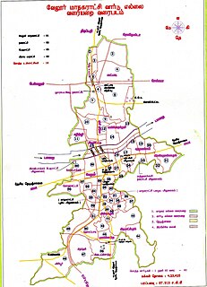
Vellore Corporation is a civic body that governs the city of Vellore, Tamil Nadu, India. Vellore corporation consist of 60 wards and is headed by a mayor who presides over a Deputy Mayor and 60 Councillors who represent each wards in the city. Deputy collector in 1982 in Vellore was R.Kulandaivelu Pillai.

Peravallur Neighbourhood in Chennai, Tamil Nadu, India

Peravallur is a developed residential area, located on the north - western corner of Madras, a metropolitan city in Tamil Nadu state, India. Out of 1018 places to be renamed by the government of Tamil Nadu, Peravallur is the one to be renamed as "Peravalloor". CMDA is the town planning agency for Peravallur. Official language is Tamil; Postal pincode is 600082; Greater Chennai Corporation is the Civic body. A police station viz., K - 5 Peravallur Police Station for this neighborhood is built a year ago with ample space, at the junction of Venkatesan Salai and Siva Elango Salai in Jawahar Nagar near Perambur.

Thiru. Vi. Ka Nagar Neighbourhood in Chennai, Tamil Nadu, India

Thiru. Vi. Ka. Nagar or TVK Nagar or Thiru. V. Kalyaanasundaram Nagar, named after the Tamil scholar Thiru. V. Kalyanasundaram, is a developed residential area in North Chennai, a metropolitan city in Tamil Nadu, India.

Jawahar Nagar Neighbourhood in Chennai, Tamil Nadu, India

Jawahar Nagar, named after the former Prime Minister of India, Jawaharlal Nehru, is a developed residential area in North Chennai, a metropolitan city in Tamil Nadu, India.

Sembium Neighbourhood in Chennai, Tamil Nadu, India

Sembium is a Neighbourhood in Chennai, near to Perambur and a developed residential area in North Chennai, a metropolitan city in Tamil Nadu, India, located at an altitude of 9 m above mean sea level. Sembium was a municipality until it was annexed by Chennai. Sembium Post office is situated in Teeds Garden fourth street. Sembium Police station is located on Paper Mills road.

Karivedu Village in Tamil Nadu, India

Karivedu is famed village is located in Ranipet district, Tamil Nadu. The initial present in the name of the village literally signifies the town Kalavai which is present nearby to the village. To discriminate karivedu from Vellore district the name is used by Karivelangadu. Karivedu is situated in between Arcot and Kalavai road. It is 15 km from Arcot and 8 km from Kalavai. It belongs to Arcot municipality and taluk. The postal pincode is 632506.

Sakkaramallur is an Indian village panchayat located in Arcot Taluk of Vellore District in the state of Tamil Nadu. Sakkaramallur is located on Right Bank of Palar River.

Kandipedu Neighbourhood in Vellore District, Tamil Nadu, India

Kandipedu is a village in Katpadi, at the northern part of Vellore city in the Indian state of Tamil Nadu. It sits on the Katpadi-Vallimalai railway line, near Thiruvalluvar University, one of India's premier educational institutions.

References

  1. "Census of India 2001: Data from the 2001 Census, including cities, villages and towns (Provisional)". Census Commission of India. Archived from the original on 16 June 2004. Retrieved 1 November 2008.