Related Research Articles

Dayton–Wright Brothers Airport is a public airport located 10 miles (16 km) south of the central business district of Dayton, Ohio, located mainly in Miami Township, Montgomery County and partly in Clearcreek Township, Warren County, near the suburb of Springboro. It is owned and operated by the City of Dayton and serves as the reliever airport for Dayton International Airport. It mainly serves corporate and personal aircraft users. The airport's identifying code, MGY, is a reference to its former name of Montgomery County Airport.
Ohio University Airport or Gordon K. Bush Airport, also known as Snyder Field, is a public-use airport located on State Route 32/U.S. 50 in the village of Albany, about ten miles (16 km) southwest of the city of Athens, in Athens County, Ohio, United States.
Wend Valley Airport is a privately-owned, public-use general aviation airport located northwest of Charlotte in Eaton County, Michigan, United States.
Portage County Airport, also known as Portage County Regional Airport, is a public use airport in Portage County, Ohio, United States. It is owned by the Portage County Board of Commissioners and located three nautical miles (6 km) north of Ravenna, in Shalersville Township. This airport is included in the National Plan of Integrated Airport Systems for 2011–2015, which categorized it as a general aviation facility.
Campbell Airport is a public-use airport located two miles (3 km) southwest of the central business district of Grayslake, a village in Lake County, Illinois, United States. It is privately owned by Kane Illinois Properties, Inc.
Newark–Heath Airport is a public airport located in Heath, Ohio. It is three miles (4.8 km) southwest of the central business district of Newark, a city in Licking County, Ohio, United States. The airport was opened in 1930 by the city of Newark, and was transferred to the Licking County Regional Airport Authority in 1967. The airport currently has a McDonnell Douglas F-4C Phantom II S.N. 64–0683 on static display.

Union County Airport is a public use airport in Union County, Ohio, United States. It is owned by the Union County Airport Authority and located one nautical mile (2 km) southeast of the central business district of Marysville, Ohio. This airport is included in the National Plan of Integrated Airport Systems for 2011–2015, which categorized it as a general aviation facility.
Mason County Airport is a county-owned public-use airport located two miles (3 km) northeast of the central business district of Ludington, a city in Mason County, Michigan, United States.
Medina Municipal Airport is a public use airport in Medina County, Ohio, United States. It is owned by the City of Medina and is located four nautical miles (7.41 km) east of the city's central business district. According to the FAA's National Plan of Integrated Airport Systems for 2007-2011, it is categorized as a reliever airport.

Sault Ste. Marie Municipal Airport, also known as Sanderson Field, is a city-owned, public-use airport located 1 nmi (1.9 km) southwest of the central business district of Sault Ste. Marie, a city in Chippewa County, Michigan, United States.
Paul C. Miller–Sparta Airport is a public airport located 3 mi (5 km) southeast of Sparta, Michigan. Established in 1941, the airport is currently owned and operated by the Village of Sparta and is self-supporting, requiring no public funding. It is included in the Federal Aviation Administration (FAA) National Plan of Integrated Airport Systems for 2017–2021, in which it is categorized as a regional general aviation facility.
Galion Municipal Airport is three miles northeast of Galion in Crawford County, Ohio. The FAA's National Plan of Integrated Airport Systems for 2009–2013 classified it as a general aviation airport.
Meyers–Diver's Airport is located in Tecumseh, Michigan, United States. It is at an elevation of 815 feet. It is owned by Al Meyers Airport, Inc., and managed by Andy Alto.
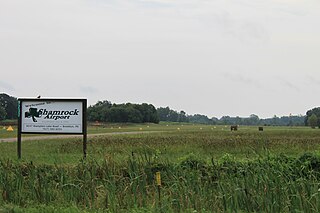
Brooklyn Airport, also known as Shamrock Field, is a privately owned, public-use airport located in Brooklyn, Michigan, United States. It sits at an elevation of 987 feet.
Jack Barstow Airport, also known as Jack Barstow Municipal Airport, is a city-owned, public-use airport located three nautical miles (6 km) northwest of the central business district of Midland, a city in Midland County, Michigan, United States. It is included in the Federal Aviation Administration (FAA) National Plan of Integrated Airport Systems for 2017–2021, in which it is categorized as a local general aviation facility.
Dalton Airport is a privately owned, public use airport located two nautical miles (4 km) east of the central business district of Flushing, in Genesee County, Michigan, United States. It is named after its founder, Edwin P. Dalton, who opened it in 1946 on the former site of the Marsa farm.
Menominee Regional Airport is a public use airport located 1 mile (2 km) northwest of the central business district of Menominee, Michigan, a city in Menominee County, Michigan, United States. It is included in the Federal Aviation Administration (FAA) National Plan of Integrated Airport Systems for 2021–2025, in which it is categorized as a local general aviation facility.
South Haven Area Regional Airport is a public-use airport located 3 miles south of South Haven, Michigan. It is publicly owned by the city through the South Haven Area Regional Airport Authority.
Andrews University Airpark is a privately owned, public use airport located 2 miles west of Berrien Springs, Michigan. It is owned and managed by Andrews University, a Seventh Day Adventist university that manages an aviation department.
Weltzien Skypark is a privately owned, public use airport located 3 miles west of Wadsworth, Ohio, in Medina County. The airpark sits on 26 acres at an elevation of 1210 feet.
References
- 1 2 3 "AirNav: KHAI - Three Rivers Municipal/Dr Haines Airport". www.airnav.com. Retrieved 2023-02-16.
- 1 2 3 "HAI - Three Rivers Municipal/Dr Haines Airport | SkyVector". skyvector.com. Retrieved 2023-02-16.
- ↑ "(KHAI) Three Rivers Muni/Dr Haines Airport". Aircraft Owners and Pilots Association. Retrieved 2023-02-16.
- ↑ Rietsma, Jef (2008-04-24). "Three Rivers declines use of airport for replacement workers". mlive. Retrieved 2023-02-16.
- ↑ "WMU Air Race Classic team places fifth in collegiate division". Western Michigan University. 2015-07-03. Retrieved 2023-02-16.
- ↑ "Municipal Airport". www.threeriversmi.org. Retrieved 2023-03-08.
- ↑ "Conrad Aero". BestAviation.net. Retrieved 2023-02-16.
- ↑ "City of Three Rivers". Aircraft Owners and Pilots Association. Retrieved 2023-02-16.
- ↑ "Cessna 150F crash in Michigan (N8082F) | PlaneCrashMap.com". planecrashmap.com. Retrieved 2023-02-16.
- ↑ "Piper PA-28-180 crash in Michigan (N3470R) | PlaneCrashMap.com". planecrashmap.com. Retrieved 2023-02-16.
- ↑ "Cessna 172M crash in Michigan (N30380) | PlaneCrashMap.com". planecrashmap.com. Retrieved 2023-02-16.
- ↑ "Cessna T182 crash in Michigan (N11344) | PlaneCrashMap.com". planecrashmap.com. Retrieved 2023-02-16.
- ↑ "Collision with Object (Non-Controlled Flight into Terrain): American Champion 8GCBC Scout, N133PJ; accident occurred August 19, 2020 at Three Rivers Municipal Dr. Haines Airport (KHAI), St. Joseph County, Michigan". Kathryn's Report. August 20, 2020. Retrieved 2023-02-16.