Szabolcs-Szatmár-Bereg is an administrative county in north-eastern Hungary, bordering Slovakia, Ukraine, and Romania. It shares borders with the Hungarian counties Hajdú-Bihar and Borsod-Abaúj-Zemplén. The capital of Szabolcs-Szatmár-Bereg county is Nyíregyháza.
Sárvár is a town in Vas County, Hungary.

Sirok is a village in Heves County, Hungary, in the Mátra mountain range, beside of the Tarna River. As of 2022 census, it has a population of 1625. The village located 18.9 km from Eger, the capital of the county and beside of the Kisterenye–Kál-Kápolna railway line, 23.9 km from the main road 3 and 24.5 km from the M25 expressway. Kőkút is located 5.2 km southwest of the center of the village, which is an other inner area of 185 people with its own railway stop. Next to the road leading there is Sirok's own railway stop, 3.5 km from the center. Although the settlement has its two own railway stops, public transport on the railway line ceased on 3 March 2007. The closest train station with public transport is in Eger 20.5 km away.
Bíňa is a municipality and village in the Nové Zámky District in the Nitra Region of south-west Slovakia.

Vállaj is a village in Szabolcs-Szatmár-Bereg county, in the Northern Great Plain region of eastern Hungary. Vállaj is a settlement in the south-eastern corner of Szabolcs-Szatmár-Bereg county, by the Kraszna river, next to the Hungarian-Romanian border.
Ura is a village in Szabolcs-Szatmár-Bereg County in the Northern Great Plain region of eastern Hungary. Small Hungarian village near the Hungarian-Ukrainian border.

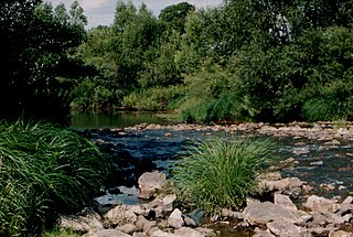
Túristvándi is a village in Szabolcs-Szatmár-Bereg county, in the Northern Great Plain region of eastern Hungary. It is located in the eastern part of the county, in Satu Mare, on the shores of the Old Tour, in a wonderful natural environment, less than 5 kilometers from the Ukrainian border.
Tunyogmatolcs is a village in Szabolcs-Szatmár-Bereg county, in the Northern Great Plain region of eastern Hungary.
Tiszanagyfalu is a village in Szabolcs-Szatmár-Bereg county, in the Northern Great Plain region of eastern Hungary.

Pásztó is a town in Nógrád County, Hungary, beside of the Zagyva river and the Kövicses creek, between the Mátra and Cserhát mountain ranges. As of 2022 census, it has a population of 8664. The town located beside of the Hatvan–Fiľakovo railway line and the main road 21 and 28.9 km from the M3 motorway. The settlement has an own railway station with public transport. An other railway stop is in the north end of the town named as Mátraszőlős-Hasznos, what is the common railway stop pf Mátraszőlős and the northeast part of the town (Hasznos).

Nemti is a village in Nógrád County, Hungary, beside of the Zagyva river. As of 2022 census, it has a population of 675. The village located beside of the Kisterenye–Kál-Kápolna railway line, 6.6 km from the main road 21 and 49.0 km from the M3 motorway. Although the settlement has its own railway stop, but public transport on the railway line ceased on 3 March 2007. The closest train station with public transport in Bátonyterenye 6.6 km far.

Feldebrő is a village in Heves County, Hungary, beside of the Tarna River. As of 2022 census, it has a population of 1000. The village located beside of the Kisterenye–Kál-Kápolna railway line and 6,8 km far from the main road 3 and 12,5 km far from the M3 motorway. Although the settlement has its own railway stop, public transport on the railway line ceased on March 3, 2007. The closest train station with public transport in Kál 10,1 km far.

Parád is a large village in Heves County, Hungary, in the Mátra mountain range, the bottom of the northern side of the Kékes peak, beside of the Parádi-Tarna creek. As of 2022 census, it has a population of 1862. The village located 6.4 km from Kisterenye–Kál-Kápolna railway line, 27.9 km from the main road 3 and 34.5 km from the M3 motorway. Although the Recsk-Parádfürdő railway station is the closest, but public transport on the railway line ceased on 3 March 2007. The closest train station with public transport in Gyöngyös 26,9 km far. The eastern end of the village (Parádfürdő) have an own postal code (3244).

Parádsasvár is a village in Heves County, Hungary, in the Mátra mountain range, the bottom of the eastern side of the Galya-tető peak, the Parádi-Tarna creek flows through the settlement. As of 2022 census, it has a population of 335. The village located 10.7 km from Kisterenye–Kál-Kápolna railway line, 25.6 km from the main road 3 and 32.2 km from the M3 motorway. Although the Recsk-Parádfürdő railway station is the closest, but public transport on the railway line ceased on 3 March 2007. The closest train station with public transport in Bátonyterenye 22.7 km far.

Verpelét is a town in Heves County, Hungary, under the Mátra mountain range, beside of the Tarna River. As of 2022 census, it has a population of 3738. The town located 17.3 km from Eger, the capital of the county and beside of the Kisterenye–Kál-Kápolna railway line, 10.7 km from the main road 3 and 16.4 km from the M3 motorway. Although the settlement has its own railway station, public transport on the railway line ceased on 3 March 2007. The closest train station with public transport is in Kál 14.0 km away.

Kápolna is a village in Heves County, Hungary, beside of the Tarna River. As of 2022 census, it has a population of 1,468. The village located beside of the Kisterenye–Kál-Kápolna railway line and on the main road 3 and 5,7 km far from the M3 motorway. Although the settlement has its own railway stop, public transport on the railway line ceased on March 3, 2007. The closest train station with public transport in Kál 3,3 km far.

Mátraderecske is a village in Heves County, Hungary, under the Mátra mountain range, beside of the Balla creek. As of 2022 census, it has a population of 1750. The village located beside of the Kisterenye–Kál-Kápolna railway line, 25.2 km from the main road 21 and 34.4 km from the M25 expressway. Although the settlement has its own railway stop, public transport on the railway line ceased on 3 March 2007. The closest train station with public transport is in Bátonyterenye 25.3 km away.

Mátraballa is a village in Heves County, Hungary, under the Mátra mountain range, beside of the Balla creek. As of 2022 census, it has a population of 668. The village located 18.8 km from the main road 21 and 40.8 km from the M25 expressway. The Kisterenye–Kál-Kápolna railway line going across the village. Although the settlement has its own railway station, public transport on the railway line ceased on 3 March 2007. The closest train station with public transport is in Bátonyterenye 18.9 km away.

Aldebrő is a village in Heves County, Hungary, beside of the Tarna River. As of 2022 census, it has a population of 675. The village located beside of the Kisterenye–Kál-Kápolna railway line and 3,8 km far from the main road 3 and 9,5 km far from the M3 motorway. Although the settlement has its own railway stop, public transport on the railway line ceased on March 3, 2007. The closest train station with public transport in Kál 7,1 km far.

Tófalu is a village in Heves County, Hungary, beside of the Tarna River. As of 2022 census, it has a population of 537. The village located beside of the Kisterenye–Kál-Kápolna railway line and 2,2 km far from the main road 3 and 8 km far from the M3 motorway. Although the settlement has its own railway stop, public transport on the railway line ceased on March 3, 2007. The closest train station with public transport in Kál 5,5 km far.