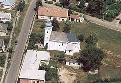
| Ófehértó | ||
|---|---|---|
| Village (község) | ||
 | ||
| ||
 Location of Nograd County in Hungary | ||
 Ófehértó Location of Ófehértó in Hungary | ||
| Coordinates: 47°56′13″N22°02′10″E / 47.93694°N 22.03611°E | ||
| Country | ||
| Region | Northern Hungary | |
| County | Szabolcs-Szatmár-Bereg County | |
| District | Baktalórántháza | |
| Government | ||
| • Mayor | Simon József (Fidesz-KDNP) | |
| Area | ||
| • Total | 43.17 km2 (16.67 sq mi) | |
| Population (1 Jan. 2015) | ||
| • Total | 2,551 | |
| • Density | 59/km2 (150/sq mi) | |
| Time zone | CET (UTC+1) | |
| • Summer (DST) | CEST (UTC+2) | |
| Postal code | 4558 | |
| Area code | 42 | |
| Website | http://ofeherto.hu/ | |

Ófehértó is a village in Szabolcs-Szatmár-Bereg County, Hungary. [1]
Szabolcs-Szatmár-Bereg is an administrative county in north-eastern Hungary, bordering Slovakia, Ukraine, and Romania. It shares borders with the Hungarian counties Hajdú-Bihar and Borsod-Abaúj-Zemplén. The capital of Szabolcs-Szatmár-Bereg county is Nyíregyháza.

Hungary is a country in Central Europe. Spanning 93,030 square kilometres (35,920 sq mi) in the Carpathian Basin, it borders Slovakia to the north, Ukraine to the northeast, Austria to the northwest, Romania to the east, Serbia to the south, Croatia to the southwest, and Slovenia to the west. With about 10 million inhabitants, Hungary is a medium-sized member state of the European Union. The official language is Hungarian, which is the most widely spoken Uralic language in the world. Hungary's capital and its largest city and metropolis is Budapest. Other major urban areas include Debrecen, Szeged, Miskolc, Pécs and Győr.

