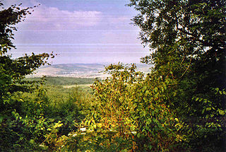
Bélapátfalva is a town in Heves County, in Hungary, located north of the city of Eger. The town is located inside the Eger river valley at an altitude of 311 meters above sea level. Facing the town is the Bél-kő mountain which rises 811 meters and is one of the highest peaks of the Bükk mountains. Because of the picturesque landscape and notable attraction the village is on the path of the National Blue Trail.
Biel is a village and municipality in the Trebišov District in the Košice Region of eastern Slovakia.

Bačka is a village and municipality in the Trebišov District in the Košice Region of eastern Slovakia.

Lontov is a village and municipality in the Levice District in the Nitra Region of Slovakia.

Krížovany is a village and municipality in Prešov District in the Prešov Region of eastern Slovakia.

Túristvándi is a village in Szabolcs-Szatmár-Bereg county, in the Northern Great Plain region of eastern Hungary.
Sonkád is a village in Szabolcs-Szatmár-Bereg county, in the Northern Great Plain region of eastern Hungary.
Ramocsaháza is a village in Szabolcs-Szatmár-Bereg county, in the Northern Great Plain region of eastern Hungary.
Panyola is a village in Szabolcs-Szatmár-Bereg county, in the Northern Great Plain region of eastern Hungary.
Kölcse is a village in Szabolcs-Szatmár-Bereg county, in the Northern Great Plain region of eastern Hungary.
Kótaj is a village in Szabolcs-Szatmár-Bereg county, in the Northern Great Plain region of eastern Hungary.
Magosliget is a village in Szabolcs-Szatmár-Bereg county, in the Northern Great Plain region of eastern Hungary.
Nagyar is a village in Szabolcs-Szatmár-Bereg county, in the Northern Great Plain region of eastern Hungary.
Nagydobos is a village in Szabolcs-Szatmár-Bereg county, in the Northern Great Plain region of eastern Hungary.
Nyírbogdány is a village in Szabolcs-Szatmár-Bereg county, in the Northern Great Plain region of eastern Hungary.

Hernádkércs is a village in Borsod-Abaúj-Zemplén County in northeastern Hungary.
Megyaszó is a village in Borsod-Abaúj-Zemplén County in northeastern Hungary.
Révleányvár is a village in Borsod-Abaúj-Zemplén County in northeastern Hungary.
Csitár is a village and municipality in the comitat of Nógrád, Hungary.
Kisar is a village in Szabolcs-Szatmár-Bereg county, in the Northern Great Plain region of eastern Hungary.


