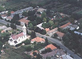
Nagycserkesz | |
---|---|
Country | |
County | Szabolcs-Szatmár-Bereg |
Area | |
• Total | 41.5 km2 (16.0 sq mi) |
Population (2015) | |
• Total | 1,778 [1] |
• Density | 42.8/km2 (111/sq mi) |
Time zone | CET (UTC+1) |
• Summer (DST) | CEST (UTC+2) |
Postal code | 4445 |
Area code(s) | 42 |
Nagycserkesz (Veľký Čerkes, in Slovak) is a village in Szabolcs-Szatmár-Bereg county, in the Northern Great Plain region of eastern Hungary.
The Northern Great Plain is a statistical region of Hungary. It is part of the Great Plain and North region. The Northern Great Plain includes the counties of Hajdú-Bihar, Jász-Nagykun-Szolnok, and Szabolcs-Szatmár-Bereg, with a total area of 17,749 km2 (6,853 sq mi) and a population of around 1.5 million.
Hungary is a country in Central Europe. Spanning 93,030 square kilometres (35,920 sq mi) in the Carpathian Basin, it borders Slovakia to the north, Ukraine to the northeast, Austria to the northwest, Romania to the east, Serbia to the south, Croatia to the southwest, and Slovenia to the west. With about 10 million inhabitants, Hungary is a medium-sized member state of the European Union. The official language is Hungarian, which is the most widely spoken Uralic language in the world, and among the few non-Indo-European languages to be widely spoken in Europe. Hungary's capital and largest city is Budapest; other major urban areas include Debrecen, Szeged, Miskolc, Pécs and Győr.
It covers an area of 41.5 km2 (16 sq mi) and has a population of 1778 people (2015). [1]
Körösújfalu is a village in Békés County, in the Southern Great Plain region of south-east Hungary.
Vámospércs is a town in Hajdú-Bihar county, in the Northern Great Plain region of eastern Hungary.
Fegyvernek is a town in Jász-Nagykun-Szolnok county, in the Northern Great Plain region of central Hungary.
Tiszavasvári is a town in Szabolcs-Szatmár-Bereg county, in the Northern Great Plain region of eastern Hungary.
Tiszakanyár is a village in Szabolcs-Szatmár-Bereg county, in the Northern Great Plain region of eastern Hungary.
Szorgalmatos is a village in Szabolcs-Szatmár-Bereg county, in the Northern Great Plain region of eastern Hungary.
Nagyszekeres is a village in Szabolcs-Szatmár-Bereg county, in the Northern Great Plain region of eastern Hungary.
Jármi is a village in Szabolcs-Szatmár-Bereg county, in the Northern Great Plain region of eastern Hungary.
Kishódos is a village in Szabolcs-Szatmár-Bereg county, in the Northern Great Plain region of eastern Hungary.
Kisszekeres is a village in Szabolcs-Szatmár-Bereg county, in the Northern Great Plain region of eastern Hungary.
Levelek is a village in Szabolcs-Szatmár-Bereg county, in the Northern Great Plain region of eastern Hungary.
Nagyhódos is a small village in Szabolcs-Szatmár-Bereg county, in the Northern Great Plain region of eastern Hungary.
Nyíribrony is a village in Szabolcs-Szatmár-Bereg county, in the Northern Great Plain region of eastern Hungary.
Kerepes is a village in Pest county, Budapest metropolitan area, Hungary. It has a population of 9,903 (2008). Olympian Zoltán Sándor was born here.
Szigetszentmárton is a village in Pest county, Hungary.
Paleu is a commune located in Bihor County, Romania. It is composed of three villages: Paleu, Săldăbagiu de Munte (Hegyközszáldobágy) and Uileacu de Munte (Hegyközújlak). These were part of Cetariu Commune until 2003, when they were split off.
Harsány is a village in Borsod-Abaúj-Zemplén County in northeastern Hungary.
Kesznyéten is a village in Borsod-Abaúj-Zemplén County in northeastern Hungary.
Kiscsécs is a village in Borsod-Abaúj-Zemplén County in northeastern Hungary.
Nagycsécs is a village in Borsod-Abaúj-Zemplén County in northeastern Hungary.
Coordinates: 47°58′N21°32′E / 47.967°N 21.533°E
A geographic coordinate system is a coordinate system that enables every location on Earth to be specified by a set of numbers, letters or symbols. The coordinates are often chosen such that one of the numbers represents a vertical position and two or three of the numbers represent a horizontal position; alternatively, a geographic position may be expressed in a combined three-dimensional Cartesian vector. A common choice of coordinates is latitude, longitude and elevation. To specify a location on a plane requires a map projection.
This Szabolcs-Szatmár-Bereg location article is a stub. You can help Wikipedia by expanding it. |