Tikiapara

Last updated

Tikiapara
Neighbourhood
Panchdeep tower under construction.jpg
Panchdeep Tower at Belilious Park, Tikiapara
Kolkata location map EN.svg
Red pog.svg
Tikiapara
Location in West Bengal, India
West Bengal location map.svg
Red pog.svg
Tikiapara
Tikiapara (West Bengal)
India location map.svg
Red pog.svg
Tikiapara
Tikiapara (India)
Coordinates: 22°35′43″N88°19′26″E / 22.59528°N 88.32389°E / 22.59528; 88.32389
CountryFlag of India.svg  India
State West Bengal
Division Presidency
District Howrah
City Howrah
Metro Station Howrah Maidan(under construction) and Howrah(under construction)
Government
  Type Municipal Corporation
  Body Howrah Municipal Corporation
Languages
  Official Bengali, Hindi, English Urdu
Time zone UTC+5:30 (IST)
PIN
711101
Telephone code+91 33
Vehicle registration WB
HMC wards19, 20, 22
Lok Sabha constituency Howrah
Vidhan Sabha constituency Howrah Madhya and Shibpur
Website wb.gov.in

Tikiapara is a neighbourhood in Howrah of Howrah district in the Indian state of West Bengal. It is adjacent to Kadamtala & Howrah Maidan and on its eastern side lies the Salkia and Pilkhana region. It is a part of the area covered by Kolkata Metropolitan Development Authority (KMDA). [1]

Contents

Tikiapara also has a railway station by its name. It lies on the South-Eastern Railway. Local trains connects it to Dasnagar and Howrah Railway Station, which in turn will connect it to the presently under-construction Howrah Metro Station in the future.

The economy of this region is dependent on the iron and casting industry mostly small and medium-sized, which makes it an industrial region of the city. Large part of the population serve as a work force for businesses located in Kolkata.

The Bypass Road will connect tikiapara to the Howrah Maidan Metro Station which will serve as a major transportation boost to the neighbourhood.

Tikiapara is under the jurisdiction of Howrah Police Station of Howrah City Police. It also has local Police Station namely Tikipara Police Station located in Fari.

Railway colony

There is a big railway colony built during late nineteenth century along Tikiapara railway station beside Sailen Manna Street (Formerly Bypass Road). It is managed by South Eastern Railway. The station code is TKPR. It is the next station of Howrah Station on South Eastern line. It is a flood-prone area. [2] Although no express train stops at this station, all local and passenger trains stop at Tikiapara.

Places of attraction

Shankaracharya temple and astrological training center at Tikiapara Shankaracharya temple in Howrah.jpg
Shankaracharya temple and astrological training center at Tikiapara
Shankaracharya Temple on Sailen Manna Road, Tikiapara. Shankaracharya Temple on Belilious road in Tikiapara, Howrah, West Bengal.jpg
Shankaracharya Temple on Sailen Manna Road, Tikiapara.

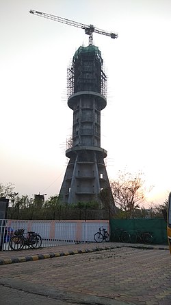
The most attractive place of Tikiapara is the Belilious Park, an amusement park. As of now, it is opened only for morning joggers, within the park there is a pond and the trees around here provide greenery to the region. A marriage hall is also present here for marriage events. A new tower is also under construction namely "Panchdeeep Tower", which after construction will be the tallest Structure in the whole city of Howrah. [3]

Food

This region has a lot of biryani shops selling mutton, chicken and beef biryani. It also has small shops selling puri, samosa, kabab, pakora and rolls. Sweets are also available in many shops. With such a variety of food available it depicts the cosmopolitan environment of Tikiapara assimilating cuisines of Muslims, Hindus and Bengalis.

People

Tikiapara is a region of mixed cultures and languages with Urdu speaking Muslim community forming a majority of the population. Most Muslims live in the central part of Tikiapara starting from Bibi Majid continuing till Fari (Tikiapara Police station).

The region has experienced a rapid rise in population, the urban infrastructure has not been able to cope up with it which has made it one of the most densely populated neighborhoods of Howrah.

While Hindus are concentrated mostly on the outskirts of in and around the central Tikiapara region. Most north Indian Hindus (Biharis and Marwaris) are concentrated in the Ashu Bose Lane & Fansitalla region.While Bengali Hindus resides west of Belilious Park till Kadamtala.

The most widely spoken languages here are Hindi, Urdu and Bengali. While most of the people are able to understand and speak in Bengali as well.

Generally, Tikiapara can be divided into two parts i.e. north and south Tikiapara with Belilious Road intersecting it into two uneven parts. There are lot of small scale industries in and around the fringes of Tikiapara. Majority of them are foundry and casting industry. Iron and steel products making small scale factories are also present. Small Printing presses can also be found.

Development is happening at a rapid rate. Income diversification is a key to people's growth. Literacy rate is also on the upward slope with more parents encouraging their children to basic education.

In Tikiapara, the rapid population increase and the prevalence of male-dominated industries have led to significant challenges for women, especially housewives. Despite their crucial role in managing households and raising families, housewives often face societal disregard and are not given the respect they deserve. The lack of financial contribution is a primary reason behind this, as they are traditionally expected to focus solely on family care. This one-dimensional perception undermines their value, leading to a lack of confidence and diminished self-esteem.

Studies reveal that in 6 out of 10 households, housewives experience low self-esteem due to being overlooked and disrespected. Their contributions are often taken for granted, as they do not directly participate in income generation. This systemic undervaluation not only affects their mental well-being but also hinders their ability to explore opportunities for personal and professional growth.

Level of hygiene has drastically improved. Rapid urbanization changed people's perspective.

Education

The oldest educational institution of Tikiapara is Howrah Muslim High School which is serving the basic requirements of primary, secondary and higher secondary education. The medium of instruction is basically Urdu. However, English and Bengali are also used as second and third language. St Joseph day school, Holy child and Sacred heart are the English medium schools.

Upper Middle Families tend to send their kids to St. Thomas church or Maria's Day School.

Now the educational system is being refined with lot of young children attending schools. The newly opened Narayana School provides high class primary and secondary and Higher Education in science stream as well.

Other educational institutions of Tikiapara include Sir Syed Ahmed High School, Tikiapara Muslim Girls High School and some other primary schools. The future of English-based education is being nourished under the tender roofs of Samaritan Mission School and Rebecca Belilious Institution, initiated by notable social worker Mamoon Sir. The institution has been granted the status of a High School and efforts are on to concretize this idea of establishing a school having all three streams- arts, commerce and science.

Related Research Articles

<span class="mw-page-title-main">Howrah</span> Metropolis in West Bengal, India

Howrah is a city in the Indian state of West Bengal. Howrah is located on the western bank of the Hooghly River, opposite its twin city of Kolkata. Administratively Howrah lies within Howrah district and is the headquarters of the Howrah Sadar subdivision; it is also part of the area covered by Kolkata Metropolitan Development Authority (KMDA). Howrah is an important industrial and transportation hub, and is also a gateway to Kolkata via Howrah railway station and Howrah Bridge.

<span class="mw-page-title-main">Shibpur</span> Neighbourhood in Presidency, West Bengal, India

Shibpur is a neighbourhood in Howrah of Howrah district in the Indian state of West Bengal. It is a part of the area covered by Kolkata Metropolitan Development Authority (KMDA).

<span class="mw-page-title-main">Howrah railway station</span> Railway station in Howrah, West Bengal, India

Howrah railway station is a railway station located in the city of Howrah, West Bengal at Kolkata metropolitan region,India. It is the largest and busiest railway complex in India, as well as one of the busiest and largest train stations in the world. It is also the oldest surviving railway complex in India. Howrah is one of the five large intercity railway stations serving the Kolkata metropolitan area, the others being Sealdah, Santragachi, Shalimar and Kolkata railway station.

<span class="mw-page-title-main">Ballygunge</span> Neighbourhood in Kolkata in West Bengal, India

Ballygunge is a locality of South Kolkata in Kolkata district in the Indian state of West Bengal. It is one of the city's most affluent neighbourhoods.

<span class="mw-page-title-main">Sodepur</span> Neighbourhood in Presidency, West Bengal, India

Sodepur is a neighbourhood in Panihati of North 24 Parganas district in the Indian state of West Bengal. It is a part of the area covered by Kolkata Metropolitan Development Authority (KMDA).

<span class="mw-page-title-main">Belgharia</span> Neighbourhood in Presidency, West Bengal, India

Belgharia is a neighbourhood in Kamarhati of North 24 Parganas district in the Indian state of West Bengal. It is a part of the area covered by Kolkata Metropolitan Development Authority (KMDA).

<span class="mw-page-title-main">Kadamtala</span> Neighbourhood in Presidency, West Bengal, India

Kadamtala is a neighbourhood in Howrah of Howrah district in the Indian state of West Bengal. It is a part of the area covered by Kolkata Metropolitan Development Authority (KMDA). Kadamtala is under the jurisdiction of Bantra Police Station of Howrah City Police.

<span class="mw-page-title-main">Rajabazar, Kolkata</span> Neighbourhood in Kolkata in West Bengal, India

Rajabazar is a locality situated in the city of Kolkata, West Bengal, India. Geographically, it lies between CIT Road and APC Road, with the neighborhood developing around Narkeldanga Main Road, now renamed Maulana Abul Kalam Azad Sarani, which connects CIT Road and APC Road. Consequently, Rajabazar is positioned between Maniktala, Narkeldanga, and Sealdah.

<span class="mw-page-title-main">Joka, Kolkata</span> Neighbourhood in Kolkata in West Bengal, India

Joka is a locality in South Kolkata, West Bengal, India. It is a part of greater Behala region. This place is mostly known for Indian Institute of Management Calcutta and ESIC Medical College and Hospital.

<span class="mw-page-title-main">Santragachhi</span> Neighbourhood in Presidency, West Bengal, India

Santragachi is a neighbourhood in Howrah of Howrah district in the Indian state of West Bengal. It is a part of the area covered by Kolkata Metropolitan Development Authority (KMDA). Santragachi Junction in Santragachi is one of the five intercity railway junctions of Howrah-Kolkata, which serves as a railway junction-cum-terminus for the South Eastern Railway. Kona Expressway in Santragachi is one of the major and fastest roads to enter Kolkata.

<span class="mw-page-title-main">Liluah</span> Neighbourhood in Presidency, West Bengal, India

Liluah is a neighbourhood in Howrah of Howrah district in the Indian state of West Bengal. It is a part of the area covered by Kolkata Metropolitan Development Authority (KMDA). Liluah has a railway junction, which is the first station after Howrah station under the Eastern Railway (India). Its history dates back to the British era when the Liluah Carriage and wagon Workshop was set up to release pressure off Howrah.

<span class="mw-page-title-main">Ramrajatala</span> Neighbourhood in Howrah

Ramrajatala is a neighbourhood in Howrah of Howrah district in the Indian state of West Bengal. It is a part of the area covered by Kolkata Metropolitan Development Authority (KMDA). Ramrajatala is under the jurisdiction of Chatterjeehat Police Station, Dasnagar Police Station and Jagacha Police Station of Howrah City Police.

<span class="mw-page-title-main">Bijoy Krishna Girls' College</span>

Bijoy Krishna Girls' College is a women's college in Howrah, India. The college offers undergraduate and postgraduate degrees and is affiliated to University of Calcutta. It is the sole girls' college in Howrah district. Formerly it was Howrah Girls' College. Presently, this college has 27 undergraduate along with 5 postgraduate departments.

Pilkhana is a neighbourhood in Howrah of Howrah district in the Indian state of West Bengal. Pilkhana is governed by Golabari Police Station under Howrah City Police. It is a part of the area covered by Kolkata Metropolitan Development Authority (KMDA).

Belepole is a neighbourhood in Howrah of Howrah district in the Indian state of West Bengal. Belepole is under the jurisdiction of Chatterjeehat Police Station of Howrah City Police. It is a part of the area covered by Kolkata Metropolitan Development Authority (KMDA). It is an urban sprawl which sprung up near the old localities of South Howrah, like Bhattacharjee Para, Chatterjeehat etc. It is located near Shibpur. It has excellent communication and transportation facilities owing to its location, its life line is Kona Expressway which connects it to the Vidyasagar Setu and hence Kolkata is just 15 minutes away. It is close to the State administrative building Nabanna.

<span class="mw-page-title-main">Bansdroni</span> Neighborhood of Kolkata in West Bengal, India

Bansdroni is a locality of South Kolkata in West Bengal, India. It is a part of the Kolkata Municipal Corporation and the Kolkata Police jurisdiction area.

<span class="mw-page-title-main">Howrah City Police</span> Police commissionerate in West Bengal, India

Howrah City Police established in 2011, is a city police force with primary responsibilities in law enforcement and investigation in Howrah city and some of its adjacent areas in Howrah district. The Commissionerate is part of the West Bengal Police and is under the administrative control of Home Ministry of West Bengal. It was formed after the bifurcation of the Howrah Police District and has eighteen police stations under its jurisdiction as of now. Presently, P. K. Tripathi, IPS is appointed as the Commissioner of the Howrah Police Commissionerate.

<span class="mw-page-title-main">Tiljala</span> Neighbourhood in East Kolkata, West Bengal, India

Tiljala is a neighbourhood of East Kolkata, in West Bengal, India.

<span class="mw-page-title-main">Garden Reach</span> Neighbourhood in Kolkata in West Bengal, India

Garden Reach is a neighbourhood of Kolkata in West Bengal, India. It is situated in the south-western part of Kolkata on the eastern banks of the Hooghly River. Localities within Garden Reach include Metiabruz, BNR Colony, Bandhabartala, Bartala, Badartala, Rajabagan and Santoshpur.

<span class="mw-page-title-main">Satyajit Ray metro station</span> Metro station in Kolkata, India

Satyajit Ray is a metro station of the Kolkata Metro Line 6 in Chak Garia, E.M. Bypass, Kolkata, India. The station is named in honour of the great Bengali filmmaker Satyajit Ray. The elevated structure is located above the Eastern Metropolitan Bypass with the Satyajit Ray Film and Television Institute and the Baghajatin Peerless Hospital on the eastern side and the Hiland Park condominium on the western side. This metro station would serve the neighbourhoods of Baghajatin, Chak Garia, Survey Park and Santoshpur of South Kolkata.

References

  1. "Base Map of Kolkata Metropolitan area". Kolkata Metropolitan Development Authority. Archived from the original on 28 September 2007. Retrieved 3 September 2007.
  2. "Tikiapara Railway Station Map/Atlas SER/South Eastern Zone - Railway Enquiry".
  3. "Belilious Park".