
Forsyth County is a county located in the northwest Piedmont of the U.S. state of North Carolina. As of the 2020 census, the population was 382,590, making it the fourth-most populous county in North Carolina. Its county seat is Winston-Salem. Forsyth County is part of the Winston-Salem, NC, Metropolitan Statistical Area, which is also included in the Greensboro–Winston-Salem–High Point, NC, Combined Statistical Area. Portions of Forsyth County are in the Yadkin Valley wine region.

Clemmons is a village in Forsyth County, North Carolina, United States and a suburb of Winston-Salem. The population was 21,177 at the 2020 census, with an estimated population of 21,517 in 2021.

Winston-Salem is a city in and the county seat of Forsyth County, North Carolina, United States. At the 2020 census, the population was 249,545, making it the fifth-most populous city in North Carolina, and the 90th-most populous city in the United States. The population of the Winston-Salem metropolitan area was estimated to be 695,630 in 2023. It is the second-most populous city in North Carolina's Piedmont Triad region, home to about 1.7 million residents.

The Piedmont Triad is a metropolitan region in the north-central part of the U.S. state of North Carolina anchored by three cities: Greensboro, Winston-Salem, and High Point. This close group of cities lies in the Piedmont geographical region of the United States and forms the basis of the Greensboro–Winston-Salem–High Point, NC Combined Statistical Area (CSA). As of 2012, the Piedmont Triad has an estimated population of 1,611,243 making it the 33rd largest combined statistical area in the United States.

Wachovia was the area settled by Moravians in what is now Forsyth County, North Carolina, United States. Of the six 18th-century Moravian "villages of the Lord" established in Wachovia, today only the town of Bethania and city of Winston-Salem exist within the historic Wachovia Tract. The historical tract was somewhat larger than present-day Winston-Salem and somewhat smaller than present-day Forsyth County.

Old Salem is a historic district of Winston-Salem, North Carolina, United States, which was originally settled by the Moravian community in 1766. It features a living-history museum which interprets the restored Moravian community. The non-profit organization began its work in 1950, although some private residents had restored buildings earlier. As the Old Salem Historic District, it was declared a National Historic Landmark (NHL) in 1966, and expanded fifty years later. The district showcases the culture of the Moravian settlement in the Province of North Carolina during the colonial 18th century and post-statehood 19th century via its communal buildings, churches, houses and shops.
The Salem Parkway is an 18.5-mile-long (29.8 km) freeway in the U.S. state of North Carolina, serving the city of Winston-Salem and the town of Kernersville. It is signed as U.S. Route 421 (US 421) for its entire length, though it is also concurrent with US 158 in downtown Winston-Salem and North Carolina Highway 150 (NC 150) between Winston-Salem and Kernersville. Originally known as the East–West Expressway, it was designated as part of Interstate 40 (I-40) and opened in 1958, becoming the first section of Interstate Highway in the state. I-40 was rerouted onto a new alignment bypassing Winston-Salem and Kernersville in 1992, at which time the road was designated Interstate 40 Business, nicknamed Business 40.

North Carolina Highway 67 (NC 67) is a 40.9-mile-long (65.8 km) primary state highway in the U.S. state of North Carolina. The highway travels through Yadkin and Forsyth Counties between its western terminus at U.S. Route 21 Business in Jonesville and NC 150 in Winston-Salem. NC 67 primarily follows an east–west alignment and connects the towns of Jonesville, Boonville, and East Bend, along with the city of Winston-Salem.
The Winston-Salem Northern Beltway is a partially completed freeway loop around the city of Winston-Salem in North Carolina. The western section has been designated as North Carolina Highway 452 (NC 452), which will become I-274 when completed, and the eastern section of the beltway will be designated as North Carolina Highway 74 (NC 74), which will become part of I-74 when completed. The entire route is in Forsyth County.
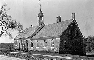
Bethabara Historic District encompasses the surviving buildings and archaeological remains of a small Moravian community, that was first settled in 1753. Located in present-day Forsyth County, North Carolina, it is now a public park of the city of Winston-Salem. It was designated National Historic Landmark in 1999.
Kaleideum in Winston-Salem, North Carolina was created from the July 2016 merger of Children's Museum of Winston-Salem and SciWorks, the Science Center and Environmental Park of Forsyth County. Currently, the museum operates two locations — Kaleideum Downtown and Kaleideum North.
The following is a timeline of the history of Charlotte, North Carolina, United States.
The following is a timeline of the history of the city of Raleigh, North Carolina, USA.
The following is a timeline of the history of the city of Fayetteville, North Carolina, USA.
The following is a timeline of the history of the city of Greensboro, North Carolina, USA.
The following is a timeline of the history of the city of Durham, North Carolina, USA.
The following is a timeline of the history of the city of Asheville, North Carolina, USA.
The following is a timeline of the history of the city of Wilmington, North Carolina, United States.
Silas Creek Parkway is a road in Winston-Salem, North Carolina, designed as a partial loop around several neighborhoods, from northwestern Winston-Salem to the southeast area of the city. The route is an expressway as it has grade-separated interchanges and is a popular connector to Interstate 40 and US 421 to other locations in the city such as Wake Forest University, Hanes Mall, and the LJVM Coliseum. The route also has several at-grade intersections with major arterial thoroughfares, especially in the southeast section, in which the route uses a boulevard grade, giving more direct accesses to several commercial districts.
William Roy Wallace was an American architect, prominent in the 20th century.

