
Quilpie is a rural town and locality in the Shire of Quilpie, Queensland, Australia. In the 2021 census, the locality of Quilpie had a population of 451 people.

Thargomindah is a rural town and locality in the Shire of Bulloo, Queensland, Australia. The town of Thargomindah is the administrative centre for the Shire of Bulloo. In the 2021 census, the locality of Thargomindah had a population of 243 people.

Tewantin is a town and locality in the Shire of Noosa, Queensland, Australia. Tewantin was the original settlement in the Noosa region and is one of its three major centres today. In the 2021 census, the locality of Tewantin had a population of 11,164 people.

Eromanga is an outback town and locality in the Shire of Quilpie, Queensland, Australia. In the 2021 census, the locality of Eromanga had a population of 98 people.
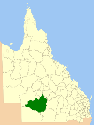
The Shire of Quilpie is a local government area in South West Queensland, Australia. It covers an area of 67,415 square kilometres (26,029 sq mi), and its administrative centre is the town of Quilpie.

Eulo is an outback town and locality in the Shire of Paroo, Queensland, Australia. It is known for its opal mining. In the 2021 census, the locality of Eulo had a population of 94 people.

Brooweena is a rural town and locality in the Fraser Coast Region, Queensland, Australia. In the 2021 census, the locality of Brooweena had a population of 91 people.
Nindigully is a rural town within the locality of Thallon in the Shire of Balonne, Queensland, Australia.

Urandangi is an outback town in the locality of Piturie in the Shire of Boulia, Queensland, Australia.
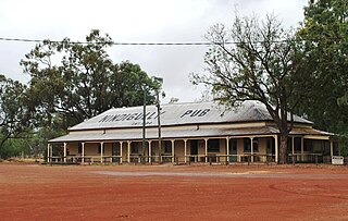
Adavale is a rural town and locality in the Shire of Quilpie, Queensland, Australia. In the 2021 census, the locality of Adavale had a population of 72 people.
Kynuna is an outback town in the Shire of McKinlay and a locality split between the Shire of McKinlay and the Shire of Winton in Queensland, Australia. In the 2021 census, the locality of Kynuna had a population of 52 people.

South West Queensland is a remote region in the Australian state of Queensland which covers 319,808 km2 (123,479 sq mi). The region lies to the south of Central West Queensland and west of the Darling Downs and includes the Maranoa district and parts of the Channel Country. The area is noted for its cattle grazing, cotton farming, opal mining and oil and gas deposits.

Cordalba is a rural town and locality in the Bundaberg Region, Queensland, Australia. In the 2021 census, the locality of Cordalba had a population of 467 people.

Duchess is a rural town and locality in the Shire of Cloncurry, Queensland, Australia. In the 2021 census, the locality of Duchess had a population of 53 people.

Thornborough is a rural town and locality in the Shire of Mareeba, Queensland, Australia. In the 2021 census, the locality of Thornborough had a population of 21 people.
Camboon is a rural locality in the Shire of Banana, Queensland, Australia. In the 2021 census, Camboon had a population of 76 people.
Prospect is a rural locality in the Shire of Banana, Queensland, Australia. In the 2021 census, Prospect had a population of 289 people.
Cheepie is a town in the locality of Adavale in Shire of Quilpie, Queensland, Australia. It has a population of 2 people.
Etna Creek is a rural locality in the Livingstone Shire, Queensland, Australia. In the 2021 census, Etna Creek had a population of 1,029 people.
Westgate is an unoccupied town in the locality of Bakers Bend in the Shire of Murweh, Queensland, Australia.

