Topsy, Tennessee | |
|---|---|
 Interactive map of Topsy, Tennessee | |
| Country | United States |
| State | Tennessee |
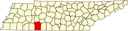
| County | Wayne |
| Elevation | 709 ft (216 m) |
| Population | |
• Total | Unknown |
| Time zone | Central (CST) |
| • Summer (DST) | CDT |
| Area code | 931 |
Topsy is an unincorporated community located in Wayne County, Tennessee. [1] A volunteer fire department and a small store are located in Topsy.
Topsy was named after a local mule noticed by the naming committee when they were unable to come up with another suitable name. [2]