Clifton Junction, Tennessee | |
|---|---|
 Clifton Junction, Tennessee | |
| Coordinates: 35°18′31″N87°56′56″W / 35.30861°N 87.94889°W | |
| Country | United States |
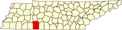
| State | Tennessee |
| County | Wayne |
| Elevation | 456 ft (139 m) |
| Time zone | Central (CST) |
| • Summer (DST) | CDT |
| Area code | 931 |
| GNIS feature ID | 1314857 |
Clifton Junction is an unincorporated community located in Wayne County, Tennessee, United States. [1] The community is located at the junction of U.S. Route 641 and U.S. Route 64. The music video for Mark Collie's song Hardin County Line was filmed in this area[ citation needed ]. Clifton Junction is located a few miles south of the city of Clifton.