
Colbert County is a county located in the northwestern part of the U.S. state of Alabama. As of the 2010 census the county's population was 54,428. The county seat is Tuscumbia. The largest city is Muscle Shoals. The county is named in honor of brothers George and Levi Colbert, Chickasaw Indian chiefs.

Lauderdale County is a county located in the northwestern corner of the U.S. state of Alabama. At the 2010 census the population was 92,709. Its county seat is Florence. Its name is in honor of Colonel James Lauderdale, of Tennessee. Lauderdale is part of the Florence-Muscle Shoals, AL Metropolitan Statistical Area, also known as "The Shoals".

Wayne County is a county located in Tennessee. As of the 2010 census, the population was 17,021. Its county seat is Waynesboro. The county is named after General "Mad Anthony" Wayne.

Lawrence County is a county located in the U.S. state of Tennessee. As of the 2010 census, the population was 41,869. Its county seat and largest city is Lawrenceburg. Lawrence County comprises the Lawrenceburg, TN Micropolitan Statistical Area, which is also included in the Nashville-Davidson-Murfreesboro, TN Combined Statistical Area.
Hickman County is a county located in the U.S. state of Tennessee. As of the 2010 census, the population was 24,690. Its county seat is Centerville.
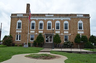
Tishomingo County is a county located in the northeastern corner of the U.S. state of Mississippi. As of the 2010 census, the population was 19,593. Its county seat is Iuka.

Jefferson County is a county located in the U.S. state of Mississippi; its western border is formed by the Mississippi River. As of the 2010 census, the population was 7,726, making it the third-least populous county in Mississippi. Its county seat is Fayette. The county is named for U.S. President Thomas Jefferson.

Cherokee is a town in west Colbert County, Alabama, United States. It is part of the Florence–Muscle Shoals metropolitan area, known as "The Shoals". As of the 2010 census, the population of the town was 1,048.

Collinwood is a city in Wayne County, Tennessee, United States. The population was 982 at the 2010 census, down from 1,024 in 2000.

The Natchez Trace, also known as the "Old Natchez Trace", is a historic forest trail within the United States which extends roughly 440 miles (710 km) from Nashville, Tennessee, to Natchez, Mississippi, linking the Cumberland, Tennessee, and Mississippi rivers.

The Natchez Trace Parkway is a national parkway in the southeastern United States that commemorates the historic Natchez Trace and preserves sections of that original trail. Its central feature is a two-lane road that extends 444 miles (715 km) from Natchez, Mississippi, to Nashville, Tennessee. Access to the parkway is limited, with more than fifty access points in the states of Mississippi, Alabama, and Tennessee. The southern end of the route is in Natchez at its intersection with Liberty Road, and the northern end is northeast of Fairview, Tennessee, in the suburban community of Pasquo, at an intersection with Tennessee State Route 100. In addition to Natchez and Nashville, larger cities along the route include Jackson and Tupelo, Mississippi, and Florence, Alabama.
The Beech River is a 38.3-mile-long (61.6 km) stream draining the east-central portion of West Tennessee in the United States. The Beech rises about 5 miles (8 km) northwest of Lexington, Tennessee. In the same area are the headwaters of two other West Tennessee rivers, the Big Sandy River and the Middle Fork of the Forked Deer River. The Big Sandy, like the Beech, is part of the Tennessee River system, whereas the Forked Deer system drains into the Mississippi River.

The Natchez Trace Trail is a designated National Scenic Trail in the United States, whose route generally follows sections of the 444-mile (715 km) Natchez Trace Parkway through the states of Tennessee, Alabama, and Mississippi. The Natchez Trace Trail is not a long, continuous footpath, as is the case with other national scenic trails ; rather, only a limited number of trail segments along the route, currently over 60 miles (97 km) of trail, have been developed for hiking and horseback riding. Moreover, the Natchez Trace Trail, unlike many others that rely heavily on volunteers for trail construction and maintenance, is managed and maintained by the National Park Service. Sections of the trail follow along the Natchez Trace Parkway road shoulder, and cross county and state roads. It was originally intended to be longer and follow most of the Natchez Trace Parkway, but only portion was built.
Grinder's Stand was a stand, or inn, located on the historic Natchez Trace. A replica can be visited today at the Meriwether Lewis Park, located on the Natchez Trace Parkway in Lewis County, Tennessee, south of Nashville, southwest of Columbia, and east of Hohenwald, Tennessee.
Leiper's Fork is an unincorporated rural village in Williamson County, Tennessee. It has a population of about 650 on an area of about 1,100 acres (450 ha). Most of the village shares a ZIP code with Franklin.

Lutts is an unincorporated community in Wayne County, Tennessee, United States. It is also known as "Pinhook."
Fly is an unincorporated community in Maury County, Tennessee. It is along the Natchez Trace Parkway, south of Nashville. The small valley known as Fly Hollow is between Fly and the Natchez Trace.
Seven segments of the historic Natchez Trace are listed on the National Register of Historic Places (NRHP). Also there are additional NRHP-listed structures and other sites along the Natchez Trace, which served the travelers of the trace and survive from the era of its active use.

Frog Jump is an unincorporated community in Crockett County, Tennessee, in the United States. The community lies along a rural stretch of State Route 88 between Halls to the west and Maury City to the east. The community's name is believed to be a humorous reference to its small size, namely that it's small enough for a frog to jump over in a single hop.
State Route 227 is a 32.3-mile-long (52.0 km) east–west state highway in extreme southern Middle Tennessee. It is the only state highway in Tennessee that both begins and ends at the Alabama state line, with one end at Cypress Inn and the other just across the state line from Lexington, Alabama.

