
Catalonia is an autonomous community on the northeastern corner of Spain, designated as a nationality by its Statute of Autonomy. Catalonia consists of four provinces: Barcelona, Girona, Lleida, and Tarragona. The capital and largest city is Barcelona, the second-most populated municipality in Spain and the core of the fifth most populous urban area in the European Union. It comprises most of the territory of the former Principality of Catalonia. It is bordered by France (Occitanie) and Andorra to the north, the Mediterranean Sea to the east, and the Spanish autonomous communities of Aragon to the west and Valencia to the south. The official languages are Catalan, Spanish, and the Aranese dialect of Occitan.
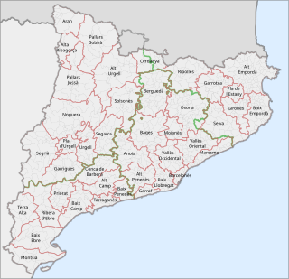
This is a list of the 42 comarques into which Catalonia is divided. A comarca is a group of municipalities, roughly equivalent to a "county" in the U.S.A. or the U.K. However, in the context of Catalonia, the term "county" can be a bit misleading, because in medieval Catalonia, aside from the kings of Aragon, the most important rulers were counts, notably the Counts of Barcelona and of Urgell. Comarques have no particular relation to the "counties" that were ruled by counts.

The Royal Abbey of Santa Maria de Poblet is a Cistercian monastery, founded in 1151, located at the foot of the Prades Mountains, in the comarca of Conca de Barberà, in Catalonia (Spain). It was founded by Cistercian monks from France on lands conquered from the Moors. The main architect was Arnau Bargués.

The Volta a Catalunya is a road bicycle race held annually in Catalonia, Spain.

Piera is a municipality that covers a large portion of the southeastern corner of the comarca of Anoia in Catalonia, Spain, on the left bank of the Anoia river. The agricultural land, mostly non-irrigated, is used for the cultivation of cereals, grapes, olives and almonds. The town itself hosts a number of light industries: textiles, plastics and construction materials. Tourism during the summer months is also relatively important for the local economy.

Cornudella de Montsant is a municipality in the comarca of the Priorat in Catalonia, Spain. It is situated in the north-west of the comarca below the Montsant range and the Prades Mountains. The Siurana reservoir is on the territory of the municipality and supplies its drinking water.
Santa Maragarida de Montbui is a municipality in the comarca of the Anoia in Catalonia, Spain. It is situated in the Òdena Basin, immediately to the west of Igualada of which it effectively forms a suburb. The ajuntament is in Sant Maure. Other neighbourhoods in Montbui are the Old Town, el Saió-Coll del Guix and La Mallola.

Saldes is a municipality in the comarca of the Berguedà in Catalonia, Spain. It is situated at the foot of the Pedraforca mountain (2497 m) in the north of the comarca. Deposits of lignite are extracted commercially. The village is linked to Guardiola de Berguedà by a local road. The monastery Sant Sebastià del Sull is located in Saldes.

Arbolí is a municipality in the comarca of the Baix Camp in Catalonia, Spain. It is situated in the west of the comarca in the Prades mountains. A local road links the village with the C-242 road.

Borredà is a municipality in the comarca of the Berguedà in Catalonia, Spain. It is situated in the upper valley of the Margençol river in the east of the comarca. There are several notable houses from the 17th and 18th centuries. The Romanesque church of Sant Sadurní de Rotgers, a protected historico-artistic monument, can be reached by a mountain track. The village is served by the C-149 road between Berga and Sant Quirze de Besora. The municipality surrounds an exclave of Les Llosses.

La Riba is a municipality in the comarca of Alt Camp, Tarragona, Catalonia, in north-eastern Spain.
Torre del Baró is a Rodalies de Catalunya station in the Nou Barris district of Barcelona in Catalonia, Spain. It was opened in the 1970s and, since 2003, interconnected with the Barcelona Metro station Torre Baró-Vallbona. It is served by Barcelona commuter rail lines R3, R4 and R7 as well as regional line R12.
Vallbona is a neighbourhood in the Nou Barris district of Barcelona, Catalonia (Spain), in the city's northern outskirts.
The following outline is provided as an overview of and topical guide to Catalonia:

Vilaverd is a municipality in the comarca of the Conca de Barberà in Catalonia, Spain.

The Catalan Transversal Range is a system of minor mountain ranges at the eastern end of the Pre-Pyrenees, between the Osona and Garrotxa comarques. The existence of the Catalan Transversal Range has made communications in the northern areas of Catalonia difficult in the past, especially between Northeastern Catalonia and Western Catalonia, a problem that has been partly solved with the development of the Eix Transversal.

Vallbona de les Monges is a municipality in the comarca of the Urgell in Catalonia, Spain. It is located at the southern end of the comarca, north of the Serra del Tallat, Catalan Pre-Coastal Range, where many wind turbines have been installed.

Serra del Tallat is a mountain range of the Catalan Central Depression, Catalonia, Spain. It has an elevation of 802 metres above sea level.

Catalunya en Miniatura is miniature park inaugurated in 1983 in Torrelles de Llobregat, 17 km from Barcelona. The park is 60,000 square meters, 35,000 of them devoted to the scale models, it is one of the largest miniature parks in the world, and the largest of the 14 miniature building exhibitions present in Europe. It displays 147 models of palaces, churches, bridges and other buildings from Catalonia and Mallorca and it includes all the major works by the renowned architect Antoni Gaudí.
The Name and Title Authority File of Catalonia (CANTIC) is an authority union catalogue within the Union Catalogue of Universities of Catalonia (CCUC), that it is led by the Biblioteca de Catalunya. Its goals are to standardize the access points in bibliographic catalogues, to improve communication among catalogues and mainly, to make easier the information research and retrieval. CANTIC gives a special treatment to name and title authorities related with Catalan culture. These authorities receive a complete authority work and provide, eventually, access to the Enciclopèdia Catalana.
