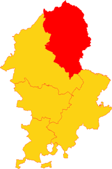
Staffordshire is a landlocked ceremonial county in the West Midlands of England. It borders Cheshire to the north-west, Derbyshire and Leicestershire to the east, Warwickshire to the south-east, the West Midlands county and Worcestershire to the south, and Shropshire to the west. The largest settlement is the city of Stoke-on-Trent, and the county town is Stafford.

Leek is a market town and civil parish in Staffordshire, England, on the River Churnet 10 miles (16 km) north east of Stoke-on-Trent. It is an ancient borough and was granted its royal charter in 1214.
Staffordshire Moorlands is a local government district in Staffordshire, England. Its council is based in Leek, the district's largest town. The district also contains the towns of Biddulph and Cheadle, along with a large rural area containing many villages. North-eastern parts of the district lie within the Peak District National Park.

Longnor is a village in the Staffordshire Peak District, England. The settlement dates from early times, the first recorded church building being in the Middle Ages. The village was named Longenalre in the Domesday Book. Located on a major crossroads, Longnor was a significant market town in the 18th century. It lies on the north bank of the River Manifold, on a limestone ridge between the Manifold and the River Dove.

Staffordshire is a landlocked county in the West Midlands of England. It adjoins Cheshire to the north west, Derbyshire and Leicestershire to the east, Warwickshire to the south east, West Midlands and Worcestershire to the south, and Shropshire to the west. The historic county of Staffordshire includes Wolverhampton, Walsall, and West Bromwich, these three being removed for administrative purposes in 1974 to the new West Midlands authority. The resulting administrative area of Staffordshire has a narrow southwards protrusion that runs west of West Midlands to the border of Worcestershire. The city of Stoke-on-Trent was removed from the admin area in the 1990s to form a unitary authority, but is still part of Staffordshire for ceremonial and traditional purposes.

Seisdon is a rural village in the parish of Trysull and Seisdon, Staffordshire approximately six miles west of Wolverhampton and the name of one of the five hundreds of Staffordshire. The population recorded at the 2011 census does not distinguish this hamlet from the rest of the parish, which had a population of 1,150.

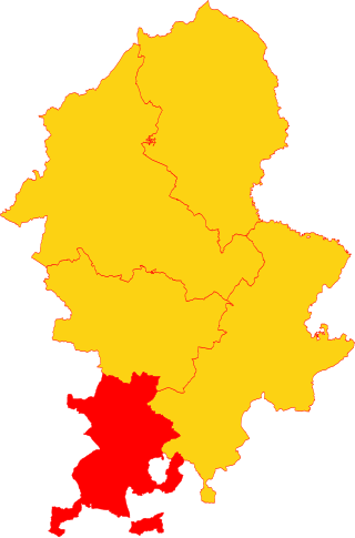
Staffordshire Moorlands is a constituency represented in the House of Commons of the UK Parliament since 2010 by Karen Bradley, a Conservative who served as Secretary of State for Culture, Media and Sport between 2016 and 2018, before she became Secretary of State for Northern Ireland from 2018 to 2019. As with all constituencies, the constituency elects one Member of Parliament (MP) by the first past the post system of election at least every five years. This seat has seen a swing to the Conservatives at the past four elections.

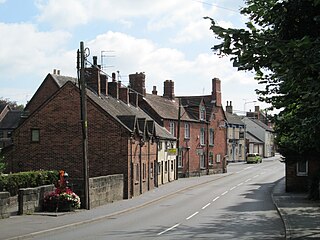
Cheadle is a market town and civil parish in the Staffordshire Moorlands District of Staffordshire, England, with a population of 12,000 at the 2021 census. It is located between Uttoxeter, Leek, Ashbourne and Stoke-on-Trent.
Hollinsclough is a small rural village in the county of Staffordshire in the English Midlands. It is within the Peak District National Park.

Stanton is a small village situated at the eastern end of the Weaver Hills, Staffordshire, England.

Leek railway station served the town of Leek, Staffordshire. It was opened by the North Staffordshire Railway in 1849. Passenger services to Uttoxeter were withdrawn in 1965, with complete closure following in 1970. For a short time in 1961–62, special football excursions were arranged to Stoke following the return of Stanley Matthews to Stoke City FC.
Tean is a large village in the civil parish of Checkley in the Staffordshire Moorlands district, in the county of Staffordshire, England. It is around 15 miles (24 km) south-east of Stoke-on-Trent. The River Tean runs through the village, heading east towards Uttoxeter.

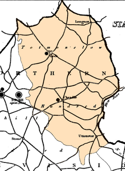
Pirehill is a hundred in the county of Staffordshire, England. The Hundred is located in the north-west and toward the upper centre of Staffordshire. It is about 28 miles in length, north to south, and around 8 to 20 miles in breadth. It is bounded on the north-east by Totmonslow (Totmanslow) Hundred, on the east by Offlow Hundred, on the south by Cuttleston Hundred, and on the west and north-west by Shropshire and Cheshire.

Calton is a village and a former parochial chapelry and civil parish, now in the parish of Waterhouses, in the Staffordshire Moorlands district of Staffordshire, England. In 1931 the parish had a population of 222. The chapelry contained the four parishes of Croxden, Blore, Mayfield, and Waterfall. In 1866, the four parishes became the civil parish of Calton, and on 1 April 1934 the parish was abolished to form Waterhouses. The village of Calton stands in the old parish of Mayfield, along with the chapel of St Mary.
Rushton is a civil parish in Staffordshire, England. The village within the civil parish, usually known as Rushton Spencer, is about 4 miles (6.4 km) north of Leek and 7 miles (11 km) south of Macclesfield, on the A523 road which runs between these towns.

Heaton is a small village and civil parish in Staffordshire, England. It is about 4 miles (6.4 km) north of Leek and about 7 miles (11 km) south of Macclesfield.

Offlow is a hundred in the county of Staffordshire, England, located in the south-east of that county. It is named after a tumulus or mound in the parish of Swinfen and Packington, 2+1⁄2 miles south of Lichfield. The hundred is recorded in the Domesday Book under the name "Offelav".

Cuttleston or Cuttlestone is a hundred in the county of Staffordshire, England, located in the centre of that county, south of Stafford.
Seisdon is a hundred in the county of Staffordshire, England, located in the south-west of that county. It is named after Seisdon, a locality in the parish of Trysull and Seisdon.

Heathylee is a civil parish in the district of Staffordshire Moorlands in north-east Staffordshire, England.