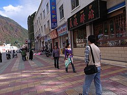
Tashkurgan is a town in the far northwest of China, close to the country's border with Tajikistan, Afghanistan, and Pakistan occupied Kashmir. It is the principal town and seat of Tashkurgan Tajik Autonomous County, in the autonomous region of Xinjiang.
Keriya Town or Mugala Town is a town in Yutian (Keriya) County, Hotan Prefecture, Xinjiang, China, on the old Southern Silk Road. As the commercial and administrative centre of Keriya County, it is about 166 km east of Hotan, 80 km east of Qira, and 120 km west of Niya. Yutian County has a population of about 160,000.

Xinhe County as the official romanized name, also transliterated from Uyghur as Toksu County, is a county in Aksu Prefecture, Xinjiang Uyghur Autonomous Region, China.

Yuli County as the official Romanized name, also transliterated from Mongolian as Lopnur County, is a county in the Xinjiang Uyghur Autonomous Region and is under the administration of the Bayin'gholin Mongol Autonomous Prefecture. It contains an area of 59,399 km2 (22,934 sq mi). According to the 2002 census, it has a population of 100,000.

Yutian County, also transliterated from Uyghur as Keriya County, is a county in Hotan Prefecture, Xinjiang Uyghur Autonomous Region, China. It contains an area of 39,023 km2 (15,067 sq mi). According to the 2002 census, it has a population of 220,000. Its government is located at Keriya Town. The county is bordered to the north by Aksu Prefecture, to the east by Minfeng/Niya County, to the west by Qira County and to the south by Rutog County and Gêrzê County in Ngari Prefecture, Tibet.
Baima is a town in Baxoi County, Chamdo Prefecture of the Tibet Autonomous Region of the People's Republic of China. It lies at an altitude of 3,772 metres (12,378 ft). As of 2020, it administers Baima Residential Community and the following eight villages:
Goyü is a township located in Zayü County, Nyingchi in eastern Tibet Autonomous Region, China. It lies at an altitude of 3,300 m (10,800 ft). The township is located approximately 60 km (37 mi) north of the county seat of Zayü.
Zongga is a town in and the seat of Gyirong County in the Himalayas of the southwestern Tibet Autonomous Region of China. It lies at an altitude of 4,130 metres (13,550 ft) and has one community and six villages under its administration.
Bazai, or Bazha, is a township in Bainang County, in the Shigatse prefecture-level city of the Tibet Autonomous Region of China. At the time of the 2010 census, the township had a population of 5,134. As of 2019, it had 13 villages under its administration.
Bêba is a town in the west of Bayi District, Nyingchi, in the southeast of the Tibet Autonomous Region. It lies at an altitude of 3,231 metres along China National Highway 318 from Markam to Lhasa, between Bayi and Kongpo Gyamda. The Niyang River, a tributary of the Tsangpo, flows past the town.
Puqu or Burqug is a township located in the south of Bayi District, Nyingchi, Tibet Autonomous Region, China.
Golag is a township in the northeast of Zayü County, Nyingchi, in the southeast of the Tibet Autonomous Region.
Yuzhou is a district and the seat of the city of Yulin, in the Guangxi Zhuang Autonomous Region, People's Republic of China, and, as its only district, is synonymous with Yulin's urban area.
Baidi is a small village in Baidi Township, Nagarzê County, Lhoka (Shannan) Prefecture, Tibet Autonomous Region, China. It is located at the western end of Yamdrok Lake. Near the village the Yamdrok Hydropower Station, the largest power station in Tibet, was completed and dedicated in 1996.

The oasis town of Qiemo or Cherchen is the capital of Qiemo County, Bayingolin Mongol Autonomous Prefecture, Xinjiang, China. It is on the Qiemo River and at the foot of the Qilian Mountains, on the Southern Silk Route. In ancient times, the town and the kingdom it controlled were jointly known as Shanshan.
Xiongmei is a town of Xainza County, in central Tibet Autonomous Region, China, located about 20 km (12 mi) south of Siling Lake. As of 2011, it has 10 villages under its administration.
Luojiang also transcribed from Tibetan as Norbukyungzê is a town in and the seat of Bainang County, in the Shigatse prefecture-level city of the Tibet Autonomous Region of China. At the time of the 2010 census, the town had a population of 7,243. As of 2019, it had 15 villages under its administration.