Trams in Cairo

Last updated
Trams in Greater Cairo
Mis'ki tramvai i avtobus u Kayiri.jpg
Cairo Tram
Overview
Locale Greater Cairo, Egypt
Transit type Tram
Operation
Began operation12 August 1896 (1896-08-12) [1]
Tramways du Caire - Track & Works Service (1900s).jpg
Tramways du Caire - Chief Engineer & Technical Service (1900s).jpg
Tramways du Caire - Central Service (1900s).jpg
Operator(s) Cairo Transportation Authority (CTA)
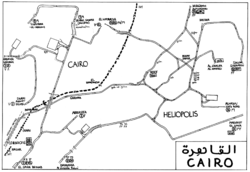
System map

StrassenbahnGleisplanKairo1996.png

Constructed near the beginning of the 20th century, until 2014 the Cairo tramway network was still used in modern-day Cairo, especially in modern areas, like Heliopolis and Nasr City. During the 1970s, government policies favoured making space for cars, resulting in the removal of over half of the 120-kilometre (75 mi) network. Trams were removed entirely from central Cairo but continued to run in Heliopolis and Helwan. [2]

Map of the Cairo and Helwan tramway lines Map of the Cairo and Helwan tramways.png
Map of the Cairo and Helwan tramway lines

However, Helwan's part of the system shut down completely in the aftermath of the 2011 Egyptian revolution, [2] and in 2014–2015 the surviving tram service in Heliopolis was almost entirely discontinued. Only a short section of one line in Heliopolis, between Court Square and the Tivoli Dome, continued to be operated. [3] By the end of 2019, service had ceased definitively, with tracks dismantled in order to widen the neighborhood's roads as well as to build bridges above the tracks. [4]
Related Research Articles

<span class="mw-page-title-main">Cairo</span> Capital city of Egypt

Cairo is the capital of Egypt and the city-state Cairo Governorate, and is the country's largest city, home to 10 million people. It is also part of the largest urban agglomeration in Africa, the Arab world and the Middle East: The Greater Cairo metropolitan area, with a population of 21.9 million, is the 12th-largest in the world by population. Cairo is associated with ancient Egypt, as the Giza pyramid complex and the ancient cities of Memphis and Heliopolis are located in its geographical area. Located near the Nile Delta, the city first developed as Fustat, a settlement founded after the Muslim conquest of Egypt in 640 next to an existing ancient Roman fortress, Babylon. Under the Fatimid dynasty a new city, al-Qāhirah, was founded nearby in 969. It later superseded Fustat as the main urban centre during the Ayyubid and Mamluk periods. Cairo has long been a centre of the region's political and cultural life, and is titled "the city of a thousand minarets" for its preponderance of Islamic architecture. Cairo's historic center was awarded World Heritage Site status in 1979. Cairo is considered a World City with a "Beta +" classification according to GaWC.

<span class="mw-page-title-main">Transport in Egypt</span>

Transport in Egypt is centered in Cairo and largely follows the pattern of settlement along the Nile. The Ministry of Transportation and other government bodies are responsible for transportation in Egypt, whether by sea, river, land or air.

<span class="mw-page-title-main">Heliopolis (ancient Egypt)</span> Ancient Egyptian city located in present-day Ayn Shams, Cairo

Heliopolis was a major city of ancient Egypt. It was the capital of the 13th or Heliopolite Nome of Lower Egypt and a major religious centre. It is now located in Ayn Shams, a northeastern district of Cairo.

<span class="mw-page-title-main">Cairo Governorate</span> Governorate in Egypt

Cairo Governorate is one of the 27 governorates of Egypt. It is formed of the city of Cairo, both the national capital of Egypt and the governorate's, in addition to five satellite cities: the New Administrative Capital - set to become the seat of national government, New Cairo, Shourok, Badr, Capital Gardens, and 15th of May. These cities form almost half of the Greater Cairo metropolitan area by population.

<span class="mw-page-title-main">Local Government in Egypt</span> Aspect of regional governance

Egypt has a centralized system of local government officially called local administration as it is a branch of the Executive. The country is divided into twenty-seven governorates, the top tier of local administration. A governorate is administered by a governor, who is appointed by the President of Egypt and serves at the president's discretion.

<span class="mw-page-title-main">Cairo International Airport</span> International airport serving Cairo, Egypt

Cairo International Airport is the principal international airport of Cairo and the largest and busiest airport in Egypt. It serves as the primary hub for Egyptair and Nile Air as well as several other airlines. The airport is located in Heliopolis, to the northeast of Cairo around fifteen kilometres from the business area of the city and has an area of approximately 37 km2 (14 sq mi).

<span class="mw-page-title-main">Cairo Metro</span> Rapid transit system in Cairo, Egypt

The Cairo Metro is the rapid transit system in Greater Cairo, Egypt. It was the first of the three full-fledged metro systems in Africa and the first in the Middle East to be constructed. It was opened in 1987 as Line 1 from Helwan to Ramsis square with a length of 29 kilometres (18.0 mi). As of 2013, the metro carried nearly 4 million passengers per day. As of October 2022, the Cairo Metro has 74 stations of which 4 are transfer stations, with a total length of 93.1 kilometres (57.8 mi). The system consists of three operational lines numbered 1 to 3.

<span class="mw-page-title-main">Cairo Electric Railways and Heliopolis Oases Company</span> Real estate company in Egypt

The Cairo Electric Railways & Heliopolis Oases Company, is ), was formed in Cairo, Egypt in 1906 to develop a 25 square kilometer plot of land into the Heliopolis suburb. It was nationalised in 1960, and remained a state-owned enterprise until it was listed on the Cairo and Alexandria Stock Exchange in 1995 and renamed the Heliopolis Company for Housing and Development.

<span class="mw-page-title-main">Helwan</span> District of Cairo in Egypt

Helwan is a suburban district in the Southern Area of Cairo, Egypt. The area of Helwan witnessed prehistoric, ancient Egyptian, Roman and Muslim era activity. More recently it was designated as a city until as late as the 1960s, before it became contiguous with the city of Cairo and was incorporated as a district. For a brief period between April 2008 and April 2011 it was redesignated as a city, and served as the capital of the now defunct Helwan Governorate that was split from Cairo and Giza governorates, before being re-incorporated back into them. The kism of Helwan had a population of 521,239 in the 2017 census.

Transport in Cairo comprises an extensive road network, rail system, subway system and maritime services for the more than 15.2 million inhabitants of the city. Cairo is the hub of almost the entire Egyptian transport network.

<span class="mw-page-title-main">Heliopolis, Cairo</span> Locality in Cairo

Heliopolis was an early 20th Century suburb outside Cairo, Egypt, which has since merged with Cairo and is administratively divided into the districts of Masr al-Gadida and al-Nozha in the Eastern Area.

<span class="mw-page-title-main">Nasr City</span> Place

Nasr City forms two of the nine districts of the Eastern Area of Cairo, Egypt. It is administratively divided into Nasr City West/One (Gharb Madinet Nasr/awwal), and Nasr City East/Two.

<span class="mw-page-title-main">Child Museum (Cairo)</span> Childrens museum in Cairo, Egypt

The Children's Civilization and Creativity Center is a children's museum in Heliopolis, Cairo, Egypt, established in 1986. It was renovated twice in 1996 and in 2012. It is a large museum and cultural center covering 4,000 square meters in a 14 Feddan, 14.3 acre landscape. It was built by the Heliopolis Society for the benefit of all the children of Egypt. This work involved contributions from Egyptian and international museums and institutions.

<span class="mw-page-title-main">Helwan Governorate</span>

Helwan Governorate was one of the governorates of Egypt. It was located in Lower Egypt.

<span class="mw-page-title-main">El Matareya, Cairo</span> Urban district in Egypt

El Matareya is a district in the Eastern Area of Cairo, Egypt. The district is unrelated to the coastal town in the Dakahlia Governorate, that is also named El Matareya. The district holds the ruins of the ancient Egyptian city of Heliopolis, one of the oldest cities of ancient Egypt.

<span class="mw-page-title-main">Cairo Metro Line 1</span>

Cairo Metro Line 1 is the first line of the Cairo Metro in Cairo, Egypt. It is the first metro system in the Africa and the Middle East. It was constructed in 1987 and connects Helwan with El Marg, stopping at 35 stations. Line 1, sometimes called the French-built line or simply the French line has a total length of 44.3 kilometres (27.5 mi) with 4.7 kilometres (2.9 mi) of it being underground and has trains that run with 3 units, which have a frequency of 2.5 minutes and a maximum speed of 100 km/h (62 mph). The line can carry 60,000 passengers per hour in each direction.

Cairo Metro Line 3 is a main line of the Cairo Metro mass transit system in Greater Cairo, Egypt.

References

  1. Abdel Rahman, Ahmed (28 December 2019). قصة مواصلات المصريين.. من الحنطور إلى الحافلة الكهربائية [The story of Egyptian transportation... from the cab to the electric bus]. Al Jazeera (in Arabic). Retrieved 2020-02-19.
  2. 1 2 "On Cairo's dying trams". cairobserver.com. 30 August 2012. Retrieved 2019-03-07.
  3. Lücker, Christian (22 June 2018). "Mega-City mit Rumpel-Tram" [Mega-city with rumble tram]. Straßenbahn Magazin (in German). No. 7/18. GeraMond Verlag GmbH. pp. 36–39. ISSN   0340-7071.
  4. "Egypte: au Caire, un quartier historique sacrifié sur l'autel de la nouvelle capitale" [Egypt: in Cairo, a historic district sacrificed on the altar of the new capital]. Geo (in French). Prisma Media (Gruner + Jahr). 11 February 2020. Retrieved 2020-02-16.