Related Research Articles

The Rio Grande in the United States or the Río Bravo in Mexico, also known as P’osoge in Tewa and Tó Ba’áadi in Navajo, is one of the principal rivers in the southwestern United States and in northern Mexico. The length of the Rio Grande is 1,896 miles (3,051 km), making it the 4th longest river in the United States and in North America by main stem. It originates in south-central Colorado, in the United States, and flows to the Gulf of Mexico. The Rio Grande drainage basin (watershed) has an area of 182,200 square miles (472,000 km2); however, the endorheic basins that are adjacent to and within the greater drainage basin of the Rio Grande increase the total drainage-basin area to 336,000 square miles (870,000 km2).
The Tijuana River is an intermittent river, 120 mi (195 km) long, near the Pacific coast of northern Baja California state in northwestern Mexico and Southern California in the western United States. The river is heavily polluted with raw sewage from the city of Tijuana, Mexico.
The Colorado River dispute is a long-running dispute between the United States and Mexico over water rights to the Colorado River.

The Colorado River Compact is a 1922 agreement that regulates water distribution among seven states in the southwestern United States. The contract is about the area within the drainage basin of the Colorado River.
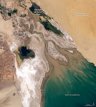
The Colorado River Delta is the region where the Colorado River flows into the Gulf of California in eastern Mexicali Municipality in the north of the state of Baja California in northwesternmost Mexico. The delta is part of a larger geologic region called the Salton Trough. Historically, the interaction of the river's flow and the ocean's tide created a dynamic environment, supporting freshwater, brackish, and saltwater species. Within the delta region, the river split into multiple braided channels and formed a complex estuary and terrestrial ecosystems. The use of water upstream and the accompanying reduction of freshwater flow has resulted in the loss of most of the wetlands of the area, as well as drastic changes to the aquatic ecosystems - an ecosystem collapse.

The International Boundary and Water Commission is an international body created by the United States and Mexico in 1889 to apply the rules for determining the location of their international boundary when meandering rivers transferred tracts of land from one bank to the other, as established under the Convention of November 12, 1884.
The Rio Grande has changed course several times in recorded history, leading to a number of border disputes and uncertainties, both international and between individual U.S. states:

The New River flows north from near Cerro Prieto, through the city of Mexicali, Baja California, Mexico, into the United States through the city of Calexico, California, towards the Salton Sea. The river channel has existed since pre-historic times. The river as known today formed from a levee failure and massive flooding that filled the Salton Sea.
The Rio Grande Compact is an interstate compact signed in 1938 in the United States between the states of Colorado, New Mexico, and Texas, and approved by the United States Congress, to equitably apportion the waters of the Rio Grande Basin.

Falcon Dam is an earthen embankment dam on the Rio Grande between Starr County in the U.S. state of Texas and the city of Nueva Ciudad Guerrero in the Mexican state of Tamaulipas. The dam was built for water conservation, irrigation, hydroelectric power generation, flood control, and recreational purposes and as an international border crossing between Zapata and Starr Counties and Tamaulipas. Construction on the dam began in December 1950 and ended in April 1954 but it was dedicated by Mexican President Adolfo Ruiz Cortines and U.S. President Dwight D. Eisenhower in October 1953.
Water resources management is a significant challenge for Mexico. The country has in place a system of water resources management that includes both central (federal) and decentralized institutions. Furthermore, water management is imposing a heavy cost to the economy.

Early in the 20th century, Monterrey, Mexico began a successful economic metamorphosis and growth pattern that remains an exception in Mexico. This all began with increased investments in irrigation that fueled a boom in agriculture and ranching for this northern Mexican city. The economic growth has fueled income disparity for the 3.86 million residents who live in the Monterrey Metro area (MMA). In addition, the rapid urbanization has taken a large toll on the water resources. In addressing many of this challenges, the city of Monterrey has become a model for sound and effective Integrated urban water management.

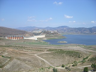
Amistad Dam is a major embankment dam across the Rio Grande between Texas, United States, and Coahuila, Mexico. Built to provide irrigation water storage, flood control, and hydropower generation, it is the largest dam along the international boundary reach of the Rio Grande. The dam is over 6 miles (9.7 km) long, lies mostly on the Mexican side of the border, and forms Amistad Reservoir. It supplies water for irrigation in the Rio Grande Valley, 574 miles (924 km) upstream of the Rio Grande's mouth on the Gulf of Mexico at Brownsville, Texas/Matamoros, Tamaulipas.
The International Wastewater Treatment Plant (IWTP) is a plant developed by the International Boundary and Water Commission (IBWC) in the South Bay area of San Diego, California. Construction began on a 75-acre site, west of San Ysidro in the Tijuana River Valley. The project, authorized by the U.S. Congress in 1989 and formally agreed between the two countries in July 1990, was part of a regional approach to solve long-standing problems, particularly the flow of sewage-contaminated water into the ocean via the Tijuana River.

The American Dam, or American Diversion Dam, is a diversion dam on the Rio Grande in El Paso, Texas, that divides the river water between Mexico and the U.S. It is about 140 feet (43 m) north of the point where the west bank of the river enters Mexico, 3.5 miles (5.6 km) from the business center. The dam is operated by the International Boundary and Water Commission. It started operation in 1938.
The International Diversion Dam is a diversion dam on the Rio Grande in Ciudad Juárez. The dam is operated by the International Boundary and Water Commission, and diverts water into the Acequia Madre for use in irrigation in Mexico. Water is diverted under the terms of the 1906 treaty on usage of Rio Grande water between the United States and Mexico.
The Riverside Diversion Dam was a diversion dam on the Rio Grande to the southeast of El Paso, Texas. The dam was owned by the United States Bureau of Reclamation, and diverted water into the Riverside Canal for use in irrigation in the El Paso Valley. The dam became obsolete with completion of a cement-lined canal carrying water from the upstream American Diversion Dam to the head of the canal. It was partially removed in 2003.
The Banco Convention of 1905, between the United States and Mexico, was negotiated and signed in 1905 and ratified by both nations in 1907. It resulted in 247 exchanges of bancos between the two nations from 1910 to 1976. Most of them were in the Lower Rio Grande Valley, the Presidio Valley and the El Paso-Juarez Valley. In 1927, the convention was applied to the short international border on the Colorado River.

The environmental impacts of the Mexico–United States border are numerous, including the disposal of hazardous waste, increase of air pollution, threats to essential water resources, and ecosystem fragmentation.

The southwestern North American megadrought is an ongoing megadrought in the southwestern region of North America that began in 2000. At least 24 years in length, the drought is the driest multi-decade period the region has seen since at least 800 CE. The megadrought has prompted the declaration of a water shortage at Lake Mead, the largest reservoir in the United States. Climate change models project drier conditions in the region through the end of the 21st century, though climate change mitigation may avoid the most extreme impacts.
References
- ↑ Mumme 2020, p. 126.
- ↑ Office of the Texas Governor 2020.
- 1 2 3 4 Tal 2007, p. 231.
- 1 2 Mumme 2004, p. 935.
- ↑ Mumme 2004, p. 929.
- ↑ Mumme 2004, p. 931.
- ↑ Mumme & Tapia-Villaseñor 2023.
- 1 2 Buono & Eckstein 2022, p. 245.
- 1 2 3 Pskowski 2024.
- ↑ Buono & Eckstein 2022, pp. 245–246.
- ↑ Mumme 2004, p. 933.
- ↑ Paddison 2024.