Trombas

Last updated • 2 min readFrom Wikipedia, The Free Encyclopedia
Trombas
Bandeira de Trombas.jpg
Brasao de Trombas.png
Goias Municip Trombas.svg
Location in Goiás state
Brazil location map.svg
Red pog.svg
Trombas
Location in Brazil
Coordinates: 13°30′29″S48°44′31″W / 13.50806°S 48.74194°W / -13.50806; -48.74194 Coordinates: 13°30′29″S48°44′31″W / 13.50806°S 48.74194°W / -13.50806; -48.74194
Country Brazil
Region Central-West
State Goiás
Microregion Porangatu Microregion
Area
  Total799.1 km2 (308.5 sq mi)
Elevation
355 m (1,165 ft)
Population
 (2020 [1] )
  Total3,498
  Density4.4/km2 (11/sq mi)
Time zone UTC−3 (BRT)
Postal code
76460-000

Trombas is a municipality in north Goiás state, Brazil.

Contents

Location

Trombas is located in the extreme north of the state, between Formoso and Montividiu do Norte. It is east of the regional center, Porangatu. The distance to Goiânia is 424 km. Highway connections are made by GO-080 / Nerópolis / São Francisco de Goiás / BR-153 / Jaraguá / GO-080 / Goianésia / Barro Alto / GO-342 / BR-080 / BR-153 / Uruaçu / Santa Tereza de Goiás / GO-241 / Formoso / GO-142.

Trombas is a municipality surrounded by the following municipalities:

Political information and demographics

In January 2005 the mayor was Elson Carlos da Silva. There were 9 members on the city council and 2,864 eligible voters in December 2007. In 2007 the population density was 4.43 inhabitants/km2. In 2007 there were 2,267 people living in the urban area and 1,270 living in the rural area. The population has decreased by almost 3,500 people since 1991.

Economy

The economy is based on cattle raising, agriculture, services, and government employment. In 2007 there were 2 industrial units and 28 retail units.

Education and health

In the educational sector there were 4 schools with 1,079 students in 2006. The adult literacy rate was 83.2% (2000) (national average was 86.4%) The town was served by one hospital with 15 beds. The infant mortality rate was 16.72 (2000) (national average was 33.0).

See also

Related Research Articles

Goianésia Municipality in Central-West, Brazil

Goianésia is a municipality in the state of Goiás, Brazil. It is a large producer of sugarcane for production of alcohol used as a source of fuel.

Porangatu Municipality in Central-West, Brazil

Parangatu is a town in Goiás state, Brazil.

Uruaçu Municipality in Central-West, Brazil

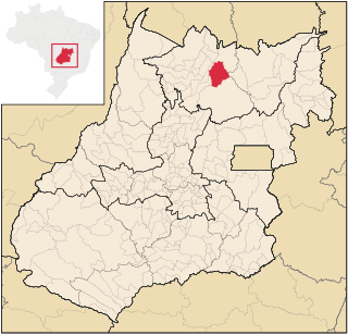
Uruaçu is a city and municipality in north Goiás state, Brazil.

Crixás, Brazil Municipality in Central-West, Brazil

Crixás is a municipality in northwestern Goiás state, Brazil. The population was 17,044 (2020) in a total area of 4,661.5 km². Crixás was a major gold producing area but is now gradually losing population.

Mara Rosa Municipality in Central-West, Brazil

Mara Rosa is a municipality in north-central Goiás state, Brazil.

Alto Horizonte Municipality in Central-West, Brazil

Alto Horizonte is a municipality in north Goiás state, Brazil. The population was 6,605 in 2020 and the area of the municipality was 503.7 km².

Hidrolina Municipality in Central-West, Brazil

Hidrolina is a municipality in north-central Goiás, Brazil. The population was 4,157 and the area of the municipality is 580 km2.

Novo Planalto Municipality in Central-West, Brazil

Novo Planalto is a municipality in north Goiás state, Brazil.

Uirapuru, Goiás Municipality in Central-West, Brazil

Uirapuru is a municipality in northwestern Goiás state, Brazil.

Estrela do Norte, Goiás Municipality in Central-West, Brazil

Estrela do Norte is municipality in north Goiás state, Brazil. The population was 3,264 (2020) and the total area was 302.7 km²

Bonópolis Municipality in Central-West, Brazil

Bonópolis is a municipality in north Goiás state, Brazil. It is largely rural with a substantial cattle herd.

Campinaçu Municipality in Central-West, Brazil

Campinaçu is a municipality in north Goiás state, Brazil.

Formoso Municipality in Central-West, Brazil

Formoso is a municipality in north Goiás state, Brazil. The population was 4,172 (2020) in a total area of 844 km².

Montividiu do Norte Municipality in Central-West, Brazil

Montividiu do Norte is a municipality in Goiás state, Brazil. It is a part of the Porangatu Microregion. It had a population in 2020 of 4,509. It became a municipality in 1993.

Mutunópolis Municipality in Central-West, Brazil

Mutunópolis is a municipality in north Goiás state, Brazil.

Santa Tereza de Goiás Municipality in Central-West, Brazil

Santa Tereza de Goias is a municipality in north Goiás state, Brazil. Santa Tereza de Goiás is often spelled "Santa Teresa de Goiás".

Nova Iguaçu de Goiás Municipality in Central-West, Brazil

Nova Iguaçu de Goiás is a municipality in north Goiás state, Brazil.

Santa Terezinha de Goiás Municipality in Central-West, Brazil

Santa Terezinha de Goiás is a municipality in north Goiás state, Brazil. Santa Terezinha is sometimes written as "Santa Teresinha".

Santa Rita do Novo Destino Municipality in Central-West, Brazil

Santa Rita do Novo Destino is a municipality in northeastern Goiás state, Brazil.

Campos Verdes Municipality in Central-West, Brazil

Campos Verdes is a municipality in north Goiás state, Brazil. Campos Verdes was known as the emerald capital of Goiás but is fast losing population as the emeralds have run out.

References