Tsaghkunyats Mountains

Last updated
Tsaghkunyats Ridge

Tsaghkunyats Range.jpg

Tsaghkunyats mountain range
Highest point
Elevation 2,851 m (9,354 ft)
Coordinates 40°33′15″N44°35′15″E / 40.55417°N 44.58750°E / 40.55417; 44.58750 Coordinates: 40°33′15″N44°35′15″E / 40.55417°N 44.58750°E / 40.55417; 44.58750
Geography
Location Armenia
Geology
Mountain type Volcanic field

Tsaghkunyats Mountains (or Tsaghkunyats Ridge), Armenian : Ծաղկունյաց լեռնաշղթա (Tsaghkunyats lernasheghta), are a range of mountains in Armenia, mainly in the provinces of Kotayk and Aragatsotn.

Armenian language Indo-European language

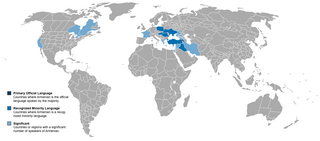
The Armenian language is an Indo-European language spoken primarily by Armenians. It is the official language of Armenia. Historically being spoken throughout the Armenian Highlands, today, Armenian is widely spoken throughout the Armenian diaspora. Armenian is written in its own writing system, the Armenian alphabet, introduced in 405 AD by Mesrop Mashtots.

Mountain A large landform that rises fairly steeply above the surrounding land over a limited area

A mountain is a large landform that rises above the surrounding land in a limited area, usually in the form of a peak. A mountain is generally steeper than a hill. Mountains are formed through tectonic forces or volcanism. These forces can locally raise the surface of the earth. Mountains erode slowly through the action of rivers, weather conditions, and glaciers. A few mountains are isolated summits, but most occur in huge mountain ranges.

Kotayk Province Province in Armenia

Kotayk, is a province (marz) of Armenia. It is located at the central part of the country. Its capital is Hrazdan and the largest city is Abovyan. It is named after the Kotayk canton of the historic Ayrarat province of Ancient Armenia.

Contents

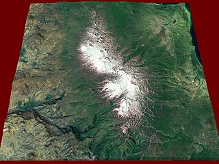
The range is of volcanic origin including many extinct volcanoes. It has a length of 42 km, stretched between Pambak Mountains near the village of Mijnatun at the north, and the right bank of Hrazdan River to the southeast. The highest peak of the Tsaghkunyats Mountains is Mount Teghenis near Tsaghkadzor, at 2851 meters. The range is formed by a volcanic field, containing Pleistocene-to-Holocene lava domes and cinder cones. [1]

Mijnatun Place in Aragatsotn Province, Armenia

Mijnatun ; formerly known as Ortachya, is a village in the Aragatsotn Province of Armenia. It is mostly populated by Yazidis.

Hrazdan River river in Armenia

The Hrazdan River is a major river and the second largest in Armenia. It originates at the northwest extremity of Lake Sevan and flows south through the Kotayk Province and Armenia's capital, Yerevan; the lake in turn is fed by several streams. In the Ararat plain it joins the Aras River along the border with Turkey. A series of hydro-electric plants have been constructed on the river. Its waters are in demand to irrigate crops.

Tsaghkadzor Place in Kotayk, Armenia

Tsaghkadzor, is a spa town and urban municipal community, as well as one of the most popular health resorts in Armenia, located north of the capital Yerevan in the Kotayk Province. According to the 2011 census, the town has a population of 1,256, down from 3,350 reported in the 1989 census. Currently, the town has an approximate population of 900 as per the 2016 official estimate.

The area is a popular mountain resort with its spa towns and villages, including Tsaghkadzor, Hankavan, Bjni, Arzakan and Aghveran.

Hankavan Place in Kotayk, Armenia

Hankavan ; formerly known as Mikhaylovka, is a village and a summer resort in the Kotayk Province of Armenia along in the Marmarik River below the Pambak mountains range. It is notable for its mineral springs, which were used as part of a sanitarium industry during the Soviet period.

Bjni Place in Kotayk, Armenia

Bjni, is a village in the Kotayk Province of Armenia. It is situated in a valley between canyon walls and a small river. The village is one of the prominent centers of education and culture of ancient and medieval Armenia. It is the birthplace of the 11th-century scholar Grigor Magistros.

Arzakan Place in Kotayk, Armenia

Arzakan, is a village in the Kotayk Province of Armenia. The Aghveran resort is located in Arzakan. There are the large ruins of the 10th- or 11th-century Neghutsi Vank, located along a ravine to the northwest of the village. There are also the 13th-century monastic ruins of Ghuki Vank and 13th-century ruins of Surb Gevorg in the vicinity.

See also

Related Research Articles

Cascade Range mountain range in western North America

The Cascade Range or Cascades is a major mountain range of western North America, extending from southern British Columbia through Washington and Oregon to Northern California. It includes both non-volcanic mountains, such as the North Cascades, and the notable volcanoes known as the High Cascades. The small part of the range in British Columbia is referred to as the Canadian Cascades or, locally, as the Cascade Mountains. The latter term is also sometimes used by Washington residents to refer to the Washington section of the Cascades in addition to North Cascades, the more usual U.S. term, as in North Cascades National Park. The highest peak in the range is Mount Rainier in Washington at 14,411 feet (4,392 m).

Caucasus Mountains mountain system in Eurasia

The Caucasus Mountains are a mountain system at the intersection of Europe and Asia. Stretching between the Black Sea and the Caspian Sea, it surrounds the eponymous Caucasus region and is home to Mount Elbrus, the highest peak in Europe.

Mount Damavand potentially active volcano or Stratovolcano and the highest peak in Iran

Mount Damavand, a potentially active volcano, is a stratovolcano which is the highest peak in Iran and the highest volcano in Asia; the Kunlun Volcanic Group in Tibet is higher than Damāvand, but are not considered to be volcanic mountains. Damāvand has a special place in Persian mythology and folklore. It is in the middle of the Alborz range, adjacent to Varārū, Sesang, Gol-e Zard, and Mīānrūd. It is near the southern coast of the Caspian Sea, in Amol County, Mazandaran Province, 66 kilometres northeast of the city of Tehran.

Mount Aragats Mountain in the Lesser Caucasus

Mount Aragats is an isolated four-peaked volcano massif in Armenia. Its northern summit, at 4,090 m (13,420 ft) above sea level, is the highest point of the Lesser Caucasus and Armenia. It is also one of the highest points in the Armenian Highlands.

Tuya volcanic field mountain in Canada

The Tuya volcanic field is a volcanic field of tuyas located in far northern British Columbia, Canada, near the border with the Yukon Territory and focused on the area of the Tuya Range, a subrange of the Stikine Ranges of the Cassiar Mountains, though some vents are in the Kawdy Plateau, the northernmost part of the Stikine Plateau. Several small shield volcanoes, and postglacial lapilli cones and lava flows have been reported in this area. The only nonglacial volcanoes in the field are Gabrielse Cone and the West Tuya lava field.

Sierra Madre de Chiapas mountain in Central America

The Sierra Madre de Chiapas is a major mountain range in Central America. The Sierra Madre de Chiapas is part of the American Cordillera, a chain of mountain ranges (cordillera) that consists of an almost continuous sequence of mountain ranges that form the western "backbone" of North America, Central America, and South America.

Tuya Butte is a tuya in the Tuya Range of north-central British Columbia, Canada. It is a bit less isolated from other ranges than neighbouring Mount Josephine. Some of the other volcanoes in the area include South Tuya, Ash Mountain, and Mathews Tuya.

Gegham mountains

Gegham mountains, Armenian: Գեղամա լեռնաշղթա are a range of mountains in Armenia. The range is a tableland-type watershed basin of Sevan Lake from east, inflows of rivers Araks and Hrazdan from north and west, Azat and Vedi rivers from south-west and Arpachai river from south. The average elevation of the Gegham mountain range is near 2500m. The range is of volcanic origin including many extinct volcanoes. The range is 70 km length and 48 km width, and stretch between Lake Sevan and the Ararat plain. The highest peak of the Gegham mountains is the Azhdahak, at 3597m. They are formed by a volcanic field, containing Pleistocene-to-Holocene lava domes and cinder cones. The highland reaches a height of 1800–2000m up to 3000m in the dividing ridge.

Buzhakan Place in Kotayk, Armenia

Buzhakan, also Romanized as Bujhakan; formerly, Babakishi), is a village in the Kotayk Province of Armenia. It is situated along the eastern foothills of the Tsaghkunyats mountain range, upon a fertile slope. Early settlers of the village began immigrating to the area in 1829 from Bitlis, Artsap, Alashkert, Mush, Sasun, and Khoy. The community has a school, kindergarten, and a library. In a wooded area to the north of Buzhakan is the well-known 10th-14th century Teghenyats Monastery, and to the east of the village are the ruins of a 6th-7th century church.

Tourism in Armenia

Tourism in Armenia has been a key sector to the Armenian economy since the 1990s when tourist numbers exceeded half a million people visiting the country every year. The Armenian Ministry of Economy reports that most of the tourists come from Russia, EU states, the United States and Iran. Though relatively small in size, Armenia has four UNESCO world heritage sites.

The Volcano (British Columbia) mountain in Canada

The Volcano, also known as Lava Fork volcano, is a small cinder cone in the Boundary Ranges of the Coast Mountains in northwestern British Columbia, Canada. It is located approximately 60 km (40 mi) northwest of the small community of Stewart near the head of Lava Fork. With a summit elevation of 1,656 m (5,433 ft) and a topographic prominence of 311 m (1,020 ft), it rises above the surrounding rugged landscape on a remote mountain ridge that represents the northern flank of a glaciated U-shaped valley.

Volcanic history of the Northern Cordilleran Volcanic Province

The volcanic history of the Northern Cordilleran Volcanic Province presents a record of volcanic activity in northwestern British Columbia, central Yukon and the U.S. state of easternmost Alaska. The volcanic activity lies in the northern part of the Western Cordillera of the Pacific Northwest region of North America. Extensional cracking of the North American Plate in this part of North America has existed for millions of years. Continuation of this continental rifting has fed scores of volcanoes throughout the Northern Cordilleran Volcanic Province over at least the past 20 million years and occasionally continued into geologically recent times.

Azhdahak vulcano from Armenia

Azhdahak is a volcano in Armenia, the highest point of Gegham mountains. It has an elevation of 3,597 m above sea. It is part of the Ghegam Ridge volcanic field, which last erupted at 1900 BC ± 1000 years.

Golden Palace Hotel

Golden Palace Hotel Resort and Spa, is a 5-star grand luxury hotel in Tsaghkadzor, a popular spa town and health resort in Kotayk Province, Armenia. It was opened in 2013 and is operated by the Australian Luxury Group organization.

Tsaghkadzor Olympic Sports Complex

Tsaghkadzor Olympic Sports Complex, is a multi-sport training complex in the mountain resort town of Tsaghkadzor, Kotayk Province, Armenia. It was opened in 1967 a state-owned sports complex of the Armenian Soviet Socialist Republic. It was entirely renovated between 2007 and 2008 with an estimated cost of US$ 8 million.

Shirak Plain

Shirak Plain, , is a plain located in the Armenian Plateau, at the northwest of Armenia. It roughly occupies almost the entire area of Shirak Province, the southwestern parts of Lori Province, as well as the northern parts of Aragatsotn Province.

References

  1. Soviet Armenian Encyclopaedia, vol. 5, page 113