
Kargil district is a district in Indian-administered Ladakh in the disputed Kashmir-region, which is administered as a union territory of Ladakh. It is named after the city of Kargil, where the district headquarters lies. The district is bounded by the Indian-administered union territory of Jammu and Kashmir to the west, the Pakistani-administered administrative territory of Gilgit–Baltistan to the north, Ladakh's Leh district to the east, and the Indian state of Himachal Pradesh to the south. Encompassing three historical regions known as Purig, Dras and Zanskar, the district lies to the northeast of the Great Himalayas and encompasses the majority of the Zanskar Range. Its population inhabits the river valleys of the Dras, Suru, Wakha Rong, and Zanskar.

Nubra, also called Dumra, is a historical region of Ladakh, India that is currently administered as a subdivision and a tehsil in the Nubra district. Its inhabited areas form a tri-armed valley cut by the Nubra and Shyok rivers. Its Tibetan name Dumra means "valley of flowers". Demands have been raised and BJP has hinted at creation of Nubra as a new district. Diskit, the headquarters of Nubra, is 120 km north of Leh, the capital of Ladakh.

Ladakh is an administrative territory of India that has been under its control since 1947. The geographical region of Ladakh union territory is the highest altitude plateau region in India, incorporating parts of the Himalayan and Karakoram mountain ranges and the upper Indus River and valley.
Qusum is a small Tibetan town and township in Qusum County in the Shannan Prefecture of Tibet, some 128km from Lhasa.

Dragsum Tsho (Tibetan: བྲག་གསུམ་མཚོ་, Wylie: brag gsum mtsho, THL: Draksum Tso, Pagsum Co, literally meaning “three rocks” in Tibetan, is a lake covering 28 square kilometres in Gongbo'gyamda County, Nyingchi of the Tibet Autonomous Region, China, approximately 300 km east of Lhasa. At 3,700 metres over sea level it is about 18 km long and has an average width of approximately 1.5 km. The deepest point of the green lake measures 120 metres. The lake is also known as Gongga Lake.

The Gankyil or "wheel of joy" is a symbol and ritual tool used in Tibetan and East Asian Buddhism. It is composed of three swirling and interconnected blades. The traditional spinning direction is clockwise, but the counter-clockwise ones are also common.
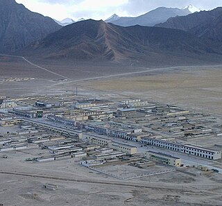
The Rutog Town , called Rituzhen in Chinese, is a town and the seat of Rutog County in the far western Tibet Autonomous Region. It is also a major military base for China near the disputed border with India allowing it to press its claims militarily.
Demchok (Tibetan: བདེ་མཆོག, Wylie: bde mchog, THL: dem chok, ZYPY: dêmqog), is a Chinese-administered village in the Zhaxigang Township, Ngari Prefecture in the Tibet Autonomous Region of China. India disputes the status and claims it as part of the Demchok sector that it regards as part of Ladakh.
Yume or Yümé, also spelt Yümai (Tibetan: ཡུལ་སྨད་, Wylie: yul smad, THL: yül mé), is a township in the Lhuntse County in Tibet region of China. Yume is on the bank of the Yume Chu river, a tributary of the Subansiri River, which it joins the China–India border close to Taksing. The township is part of the Tsari district, considered holy by Tibetans.

Zoco or Tsotso, also called Goicang is a township in Gar County, Ngari Prefecture of Tibet Autonomous Region of China.
Maryul, also called mar-yul of mnga'-ris, was the western-most Tibetan kingdom based in modern-day Ladakh and some parts of Tibet. The kingdom had its capital at Shey.
Chepzi, also spelt Chabji and Dripuche, is a village and military post in Tsamda County of Tibet in China, close to the border with India's Ladakh. Chepzi is close to Chumar in Ladakh's Rupshu region. There is evidence that the people of Chumar have traditionally used the farmlands in Chepzi, and the village was included in Ladakh during the British Raj. However, independent India excluded it from its border definition. The border has been witness to a large number of incursions by the Chinese People's Liberation Army since 2011.
Risum Township or Risong Township (simplified Chinese: 日松乡; traditional Chinese: 日松鄉; pinyin: Rìsōng Xiāng), traditionally called Roksum in English, is a township of Rutog County, in far western Tibet Autonomous Region, People's Republic of China. It is directly serviced by China National Highway 219. The closest airport is the Ali Kunsha Airport.
Spanggur Tso, also called Maindong Tso, Mendong Tso, is a saltwater lake in Rutog County in the Tibet Autonomous Region of China, close to the border with Ladakh. India claims a major portion of the lake as its own territory, as part of Ladakh. To the west of the lake lies the Spanggur Gap, a low pass through which the Line of Actual Control runs. To the north is the much larger lake Pangong Tso. Spanggur Tso is at an elevation of 4,305 meters and has an area of 61.6 square kilometres. The lake's average annual temperature is around -4 to -2 °C, and the annual precipitation is 50 to 75 mm. The western portion of the lake is claimed by India.
Chumar or Chumur is a village and the centre of nomadic grazing region located in south-eastern Ladakh, India. It is in Rupshu block, south of the Tso Moriri lake, on the bank of the Parang River, close to Ladakh's border with Tibet. Since 2012, China has disputed the border in this area, though the Chumur village itself is undisputed.

Demchok , previously called New Demchok, and called Parigas by the Chinese, is a village and military encampment in the Indian-administered Demchok sector, that is disputed between India and China. It is administered as part of the Nyoma tehsil in the Leh district of Ladakh by India, and claimed by China as part of the Tibet Autonomous Region.
Sumdorong Chu is a tributary of the Nyamjang Chu river that flows along the disputed Sino-Indian border between the Tsona County of Tibet and the Tawang district of Arunachal Pradesh. It originates in the Tokpo Shiri Glacier, about 7–10 kilometres east of Nyamjang Chu, and flows down to the river. Its junction with Nyamjang Chu is about two kilometers to the north of that of Namka Chu, another contested river valley.
The Parang River, also called Para River and Pare Chu is an upstream tributary of the Sutlej River, that originates in the Indian state of Himachal Pradesh and ends in Himachal Pradesh again, but flows through Ladakh and Tibet before doing so. The origin of the river is near the Parang La pass in the Spiti subdistrict. After its circuitous journey, it joins the Spiti River near Sumdo in Himachal Pradesh and the combined river then joins Sutlej.
Kaurik and is a village in the Lahul and Spiti district, in Himachal Pradesh, India. It is in the valley of the Parang or Pare Chu river before its confluence with the Spiti River. Kaurik is close to the border with Tibet, the opposite village on the Tibetan side being Tsurup Sumgyi. China claims the village as part of its Zanda County, Tibet.
Noh, also called Üchang or Wujang (Tibetan: དབུས་བྱང, Wylie: dbus byang, THL: wü jang) is a village in the Rutog County, Ngari Prefecture of the Tibet region of China. It is located on the northern bank of the eastern Pangong Lake, watered by the Doma River (Tsanger-schar). The village is now part of the Domar Township.


