
Venezuela is a country in South America, bordering the Caribbean Sea and the North Atlantic Ocean, between Colombia and Guyana. It is situated on major sea and air routes linking North and South America. Located at the northernmost end of South America, Venezuela has a total area of 912,050 km2 (352,140 sq mi) and a land area of 882,050 km2 (340,560 sq mi). It is the 32nd largest country and is slightly smaller than Egypt, or half the size of Mexico. Shaped roughly like an inverted triangle, the country has a 2,800 km (1,700 mi) long coastline. It is bound on the north by the Caribbean Sea and the Atlantic Ocean, on the east by Guyana, on the south by Brazil, and on the west by Colombia. It has the 55th largest Exclusive Economic Zone of 471,507 km2 (182,050 sq mi). Its maritime territory borders Trinidad and Tobago, Dominica, the Dominican Republic, Grenada, St. Kitts and Nevis, St. Vincent and the Grenadines, France, the United Kingdom, the Netherlands, and the United States. The Guyana–Venezuela territorial dispute has continued since the nineteenth century, with Venezuelan claiming a territory it calls "Guayana Esequiba", which is currently controlled by Guyana.

The Orinoco is one of the longest rivers in South America at 2,140 km (1,330 mi).

Apure State is one of the 23 states of Venezuela. Its territory formed part of the provinces of Mérida, Maracaibo, and Barinas, in accordance with successive territorial ordinations pronounced by the colonial authorities. In 1824 the Department of Apure was created, under jurisdiction of Barinas, which laid the foundations for the current entity. In 1856 it separated from Barinas and for the first time Apure appeared as an independent province, which in 1864 acquired the status of state. In 1881, however, a new territorial division combined Apure and Guayana to form a single state named Bolívar. In 1899 it reestablished its autonomy and finally, by means of the Constitution of 1909, gained its current borders.

Bolívar is one of the 23 states of Venezuela. The state capital city is Ciudad Bolívar and the largest city is Ciudad Guayana. Bolívar State covers a total surface area of 242,801 km2 (93,746 sq mi) and as of the 2011 census, had a population of 1,410,964. The state contains Angel Falls.
Delta Amacuro State is one of the 23 states of Venezuela, and is the location of the Orinoco Delta. The Paria Gulf and the Atlantic Ocean are found to the north, Bolívar State is found to the south, the Atlantic Ocean and Guyana are found to the east, and Monagas State is found to the west. The state capital city is Tucupita.
Monagas State is one of the 23 states of Venezuela.

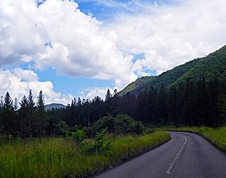
The Llanos is a vast tropical grassland plain situated to the east of the Andes in Colombia and Venezuela, in northwestern South America. It is an ecoregion of the tropical and subtropical grasslands, savannas, and shrublands biome.

The Bolivarian Republic of Venezuela is a federation made up of twenty-three states, a Capital District and the Federal Dependencies, which consist of many islands and islets in the Caribbean Sea. Venezuela claims the disputed Essequibo territory as one of its states, which it calls Guayana Esequiba, but the territory is controlled by Guyana as part of six of its regions.

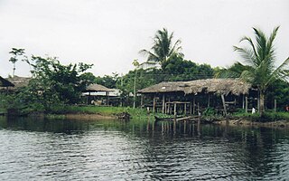
The Warao are an Indigenous Amerindian people inhabiting northeastern Venezuela, Trinidad and Tobago, Guyana, and Suriname. Alternate common spellings of Warao are Waroa, Guarauno, Guarao, and Warrau. The term Warao translates as "the boat people", after the Warao's lifelong and intimate connection to the water. Most Warao inhabit Venezuela's Orinoco Delta region, with smaller numbers in neighbouring Guyana, Trinidad and Tobago, and Suriname. With a population of 49,271 people in Venezuela during the 2011 census, they were the second largest indigenous group after the Wayuu people. They speak an agglutinative language, Warao.

The Orinoco Delta is a vast river delta of the Orinoco River, located in eastern Venezuela.

The Guayana Region is an administrative region of eastern Venezuela.

The Caño Manamo is a distributary of the Orinoco River. It branches northwards from the main channel of the Orinoco to delimit the western edge of the Orinoco Delta, ultimately emptying into the Gulf of Paria. Tucupita, the capital of Delta Amacuro state, is located on the east bank (right) of the Caño Manamo. Manamo is a Warao word meaning "two."

The Tucupita Municipality is one of the four municipalities (municipios) that makes up the eastern Venezuelan state of Delta Amacuro and, according to a 2007 population estimate by the National Institute of Statistics of Venezuela, the municipality has a population of 93,368. The town of Tucupita is the municipal of the Tucupita Municipality.

The Climate of Venezuela is characterized for being tropical and megathermal as a result of its geographical location near the Equator, but because of the topography and the dominant wind direction, several climatic types occur which can be the same as found in temperate latitudes, and even polar regions. Latitude exerts little influence on the Venezuelan climate. While the coastal cities of Maracaibo, Barcelona, Porlamar and Maiquetia can get extremely hot, cities in valleys such as Mérida, Caracas, Los Teques and San Cristobal have cooler climates, and the highest towns of Mucuchies and Apartaderos have cold (tundra) climates.

The Cathedral of the Divine Shepherdess or Tucupita Cathedral is a religious building that is affiliated with the Catholic Church and serves as the seat of the Apostolic Vicariate of Tucupita created on July 30, 1954, by bull Crescit in dies of Pope Pius XII, and it works in the city of Tucupita, Delta Amacuro state capital at the eastern end of the South American country of Venezuela. It is specifically located between Marino, La Paz and Arismendi Avenue streets.

The Orinoco Delta swamp forests (NT0147) is an ecoregion of eastern Venezuela and northern Guyana covering the large and shifting Orinoco Delta. The vegetation is mostly permanently flooded rainforest. The ecoregion is relatively intact apart from a large area that was damaged by a failed flood control program in the 1960s. It is inaccessible, so logging is difficult, and the soil is unsuitable for farming. The main threat comes from oil exploration, which would bring an influx of settlers into the delta.

The Orinoco wetlands (NT0906) is an ecoregion of northeast Venezuela within the northern Orinoco Delta. It holds areas of tall grasses in flooded land, surrounded by mangroves and swamp forest, giving way to the drier Llanos savanna in the west.
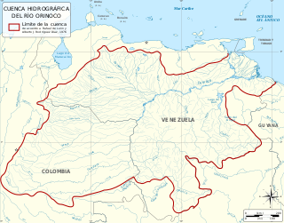
The Orinoco Basin is the part of South America drained by the Orinoco river and its tributaries. The Orinoco watershed covers an area of about 990000 km2, making it the third largest in South America, covering most of Venezuela and eastern part of Colombia.
Barranca del Orinoco is the capital of the municipality of Sotillo in the state of Monagas in Venezuela.
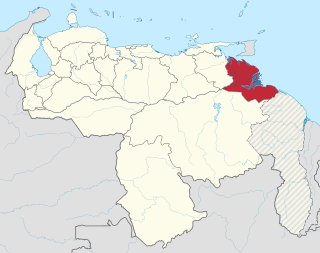
The Delta Federal Territory, later Delta Amacuro, is the name by which the current Delta Amacuro State of Venezuela was known until 1991.


