U.S. Route 1 or U.S. Highway 1 (US 1) is a major north–south United States Numbered Highway that serves the East Coast of the United States. It runs 2,370 miles (3,810 km) from Key West, Florida, north to Fort Kent, Maine, at the Canadian border, making it the longest north–south road in the United States. US 1 is generally paralleled by Interstate 95 (I-95), though US 1 is significantly farther west and inland between Jacksonville, Florida, and Petersburg, Virginia, while I-95 is closer to the coastline. In contrast, US 1 in Maine is much closer to the coast than I-95, which runs farther inland than US 1. The route connects most of the major cities of the East Coast from the Southeastern United States to New England, including Miami, Jacksonville, Augusta, Raleigh, Richmond, Washington, D.C., Baltimore, Philadelphia, Newark, New York City, New Haven, Providence, Boston, and Portland.

Interstate 95 (I-95) is the main north–south Interstate Highway on the East Coast of the United States, running from U.S. Route 1 (US 1) in Miami, Florida, north to the Houlton–Woodstock Border Crossing between Maine and the Canadian province of New Brunswick. The highway largely parallels the Atlantic coast and US 1, except for the portion between Savannah, Georgia, and Washington, D.C., and the portion between Portland and Houlton in Maine, both of which follow a more direct inland route.
Interstate 295 is the designation for the following eight Interstate Highways in the United States, all of which are related to I-95:

U.S. Route 302 is an east–west spur of U.S. Route 2 in northern New England in the United States. It currently runs 171 miles (275 km) from Montpelier, Vermont, beginning at US 2, to Portland, Maine, at U.S. Route 1. It passes through the states of Vermont, New Hampshire and Maine.

The Fore River is a short horn-shaped estuary, approximately 5.7 miles (9.2 km) long, separating Portland and South Portland in Maine in the United States. Many of the port facilities of the Portland harbor are along the estuary, which is formed just southwest of Portland by the confluence of several creeks. The estuary was initially known as Levett's River, so named by the first English settler of the Casco Bay region, Capt. Christopher Levett. But shortly afterwards, the estuary came to have the name by which it is known today.

District of Columbia Route 295 (DC 295), also known as the Anacostia Freeway as well as the Kenilworth Avenue Freeway north of East Capitol Street, is a freeway in the District of Columbia, and currently the only signed numbered route in the District that is not an Interstate Highway or U.S. Highway. Also, DC 295 is one of the few city-level signed route numbers in the United States, along with Charlotte Route 4. The south end is at the junction of I-295, I-695, and the southern end of the 11th Street Bridges, though I-295 was originally part of DC 295. Its north end is at the border with Maryland where it connects to MD 295 and US 50 via MD 201.

Interstate 295 (I-295) in Delaware, New Jersey, and Pennsylvania is an auxiliary Interstate Highway, designated as a bypass around Philadelphia, and a partial beltway of Trenton.
Interstate 295 (I-295) is a 52-mile-long (84 km) auxiliary Interstate Highway in the US state of Maine from I-95 in Scarborough to I-95 in West Gardiner. The highway was designated the Richard A. Coleman Highway in 2015 by the Maine Legislature. The highway serves as a bypass of Lewiston–Auburn and serves the Portland metropolitan area. It takes a more direct route between Portland and Augusta, the state capital, than its parent I-95. It also is toll-free, unlike I-95, which carries the tolled Maine Turnpike.
The Maine Central Railroad was a U. S. class 1 railroad in central and southern Maine. It was chartered in 1856 and began operations in 1862. By 1884, Maine Central was the longest railroad in New England. Maine Central had expanded to 1,358 miles (2,185 km) when the United States Railroad Administration assumed control in 1917. The main line extended from South Portland, Maine, east to the Canada–United States border with New Brunswick, and a Mountain Division extended west from Portland to St. Johnsbury, Vermont, and north into Quebec. The main line was double track from South Portland to Royal Junction, where it split into a "lower road" through Brunswick and Augusta and a "back road" through Lewiston, which converged at Waterville into single track to Bangor and points east. Branch lines served the industrial center of Rumford, a resort hotel on Moosehead Lake and coastal communities from Bath to Eastport.

The Falmouth Spur is a short freeway connecting Interstate 95 (I-95) with I-295 and US Route 1 (US 1) north of Portland, Maine, in the United States. It carries the unsigned designation of Interstate 495 (I-495). As part of the Maine Turnpike, the mainline of which carries I-95, the Falmouth Spur is a toll road. The spur has only two interchanges—one at each end—and a toll booth in the middle. It is signed only for its destinations—I-95, I-295, and US 1—to minimize driver confusion.

Baxter Boulevard is a boulevard and parkway in Portland, Maine. The road, around 1.91 miles (3.07 km) long, served as the means to head north from downtown Portland before Tukey's Bridge, now on Interstate 295 (I-295), was built. The road was part of U.S. Route 1 (US 1) until May 2007. The parkway wraps around the west side of Back Cove estuary basin.
Interstate 95 (I-95) is a part of the Interstate Highway System that runs north–south from Miami, Florida to Houlton, Maine. The highway enters Maine from the New Hampshire state line in Kittery and runs for 303 miles (488 km) to the Canada–United States border at Houlton. It is the only primary Interstate Highway in Maine. In 2004, the highway's route between Portland and Gardiner was changed so that it encompasses the entire Maine Turnpike, a toll road running from Kittery to Augusta. As an Interstate Highway, all of I-95 in Maine is included in the National Highway System, a network of roads important to the country's economy, defense, and mobility.

The Presumpscot River is a 25.8-mile-long (41.5 km) river located in Cumberland County, Maine, United States. It is the main outlet of Sebago Lake. The river provided an early transportation corridor with reliable water power for industrial development of the city of Westbrook and the village of South Windham.
U.S. Route 1 (US 1) in the U.S. state of Maine is a major north–south section of the United States Numbered Highway System, serving the eastern part of the state. It parallels the Atlantic Ocean from New Hampshire north through Portland, Brunswick, and Belfast to Calais, and then the St. Croix River and the rest of the Canada–United States border via Houlton to Fort Kent. The portion along the ocean, known as the Coastal Route, provides a scenic alternate to Interstate 95 (I-95).

Back Cove is an estuary basin on the northern side of the downtown district of Portland, Maine. It is almost circular in form and about 1 mile (1.6 km) in diameter.
Portland, Maine, is home to many neighborhoods.

Yarmouth is a town in Cumberland County, Maine, United States, twelve miles north of the state's largest city, Portland. When originally settled in 1636, as North Yarmouth, it was part of the Massachusetts Bay Colony, and remained part of its subsequent incarnations for 213 years. In 1849, twenty-nine years after Maine's admittance to the Union as the twenty-third state, it was incorporated as the Town of Yarmouth.
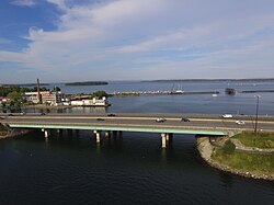
Martin's Point Bridge spans the Presumpscot River in Maine, United States, near the river’s mouth with Casco Bay. It connects Falmouth Foreside, at Mackworth Point, in the north, to the East Deering neighborhood of Portland, at Martin's Point, in the south. 1,300 feet (400 m) in length, it carries vehicular and pedestrian traffic of U.S. Route 1. The bridge is two lanes, including a bicycle lane in each, with a pedestrian lane on the eastern side. A similar plan for the western side of the bridge was abandoned.

Back Cove Trail is a 3.6-mile (5.8 km) multi-use trail in Portland, Maine. It circumnavigates Back Cove, running beside Preble Street Extension, Baxter Boulevard and Interstate 295. It is one of the oldest trails in the city.

Washington Avenue is a major street in Portland, Maine, United States. It runs for around 5.25 miles (8.45 km), from Auburn Street in the northwest to Congress Street in the southeast. It continues in parallel with Interstate 295 as it crosses Tukey's Bridge between exits 8 and 9. It is the main artery for traffic entering and leaving Portland to and from the north via city streets, and has been described as a "gateway to the Portland peninsula." Washington Avenue passes to the north of Back Cove, while Forest Avenue passes to its south.