This article needs additional citations for verification .(February 2024) |
Tunstead | |
---|---|
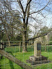
Monument to James Brindley with ash tree | |
Location within Derbyshire | |
OS grid reference | SK104741 |
Civil parish | |
District | |
Shire county | |
Region | |
Country | England |
Sovereign state | United Kingdom |
Post town | BUXTON |
Postcode district | SK17 |
Police | Derbyshire |
Fire | Derbyshire |
Ambulance | East Midlands |
Tunstead is a village in Derbyshire, England, situated above Great Rocks Dale north of Buxton. It should not be confused with Tunstead Milton, which is roughly five miles to the north west. It is in the civil parish of Wormhill.
It is famous as the birthplace of James Brindley, [1] pioneer builder of Britain's canals. He was born in 1716 in a farmhouse on the edge of the village and with the encouragement of his mother he became an apprentice millwright in Leek. [ citation needed ] By 1875 the farm had fallen into ruins, marked only by an ash tree, when a monument to his memory was placed in nearby Wormhill. By 1958, the ash tree had also gone, and the Derbyshire Archaeological Society planted a sapling in its place and erected another monument.[ citation needed ] Tunstead is also famous for the quarry, on the other side of the old Midland Railway line from Millers Dale to Chapel en le Frith. Being just outside the boundary of the Peak District National Park it is probably the most extensively worked in the area, yielding high-quality limestone exceptionally free of volcanic rock. [ citation needed ]
James Brindley was an English engineer. He was born in Tunstead, Derbyshire, and lived much of his life in Leek, Staffordshire, becoming one of the most notable engineers of the 18th Century.
Tideswell is a village, civil parish, and ward in the Peak District of Derbyshire, England. It lies 6 miles (9.7 km) east of Buxton on the B6049, in a wide valley on a limestone plateau, at an altitude of 1,000 feet (300 m) above sea level, and is within the District of Derbyshire Dales. The population was 1,820 in 2001, increasing slightly to 1,827 at the 2011 Census, making it the second-largest settlement within the National Park, after Bakewell. Tideswell Dale is a short limestone valley leading south from the village to the River Wye valley.
Darley Dale, formerly Darley, is a town and civil parish in the Derbyshire Dales district of Derbyshire, England, with a population of 5,413. It lies north of Matlock, on the River Derwent and the A6 road. The town forms part of a built-up area with both Matlock and Rowsley.
Whaley Bridge is a town and civil parish in the High Peak district of Derbyshire, England. It is situated on the River Goyt, 16 miles (26 km) south-east of Manchester, 7 miles (11 km) north of Buxton, 9 miles (14 km) north-east of Macclesfield and 28 miles (45 km) west of Sheffield. It had a population of 6,455 at the 2011 census, including Furness Vale, Horwich End, Bridgemont, Fernilee, Stoneheads and Taxal.
Dovedale is a valley in the Peak District of England. The land is owned by the National Trust and attracts a million visitors annually. The valley was cut by the River Dove and runs for just over 3 miles (5 km) between Milldale in the north and a wooded ravine, near Thorpe Cloud and Bunster Hill, in the south. In the wooded ravine, a set of stepping stones cross the river and there are two caves known as the Dove Holes.
The history of Derbyshire can be traced back to human settlement since the last Ice Age, over 10,000 years ago. The county of Derbyshire in England dates back to the 11th century.
Buxton railway station serves the Peak District town of Buxton in Derbyshire, England. It is managed and served by Northern Trains. The station is 25+3⁄4 miles (41.4 km) south east of Manchester Piccadilly and is the terminus of the Buxton line.
Millers Dale is a valley on the River Wye in Derbyshire, England, where there is also a hamlet of the same name.
Millers Dale railway station was situated in Millers Dale, near Tideswell, in the Peak District.
Wormhill is a village and civil parish in the High Peak district of Derbyshire, England, situated east by north of Buxton. The population of the civil parish including Peak Dale was 1,020 at the 2011 Census.
Peak Dale is a small village in Derbyshire, England, 3 miles (4.8 km) northeast of Buxton and 1.3 miles (2.1 km) southeast of Dove Holes. The population falls within the civil parish of Wormhill.
William Bagshaw or Bagshall (1628–1702) was an English presbyterian and nonconformist minister, known as the "Apostle of the Peak".
The Peak District Boundary Walk is a circular 190-mile (310 km) walking trail, starting and finishing at Buxton and broadly following the boundary of the Peak District, Britain's first national park. The route was developed by the Friends of the Peak District and was launched on 17 June 2017.
Chee Dale is a steep-sided gorge on the River Wye near Buxton, Derbyshire, in the Peak District of England.
Monk's Dale is a short steep-sided dry gorge near Buxton, Derbyshire, in the Peak District of England. The dale is cut into a plateau of farmland and lies to the east of the village of Wormhill. The head of the valley leads into Peter Dale to the north. Miller's Dale is at the foot of the valley to the south.
Hay Dale is a short dry valley near Buxton, Derbyshire, in the Peak District of England. It is part of a longer valley that runs for approximately 4 miles (6.4 km) north–south from Peak Forest to the River Wye at Millers Dale. This valley has several names along its length: from the northern end running downhill these are Dam Dale, Hay Dale, Peter Dale and Monk's Dale. There is a farmland plateau on either side.
The Buxton lime industry has been important for the development of the town of Buxton in Derbyshire, England, and it has shaped the landscape around the town.
The Wye Valley is the limestone valley of the River Wye in the White Peak of Derbyshire, England. The source of the River Wye is west of Buxton on Axe Edge Moor. One main channel runs underground through Poole's Cavern. The river flows though Buxton Pavilion Gardens and then along a culvert under the town centre. After leaving the flat area of central Buxton, the Wye Valley becomes distinct as a gorge running east for 10 miles (16 km) before the valley broadens at Ashford-in-the Water.
Wormhill is a civil parish in the High Peak district of Derbyshire, England. The parish contains 26 listed buildings that are recorded in the National Heritage List for England. Of these, three are listed at Grade II*, the middle of the three grades, and the others are at Grade II, the lowest grade. The parish contains the village of Wormhill and the surrounding area. Most of the listed buildings are houses, cottages and associated structures, farmhouses and farm buildings. The other listed buildings include a church and associated structures, a village cross moved into the churchyard, a railway viaduct, and a memorial fountain.