In archaeology, a broch is an Iron Age drystone hollow-walled structure found in Scotland. Brochs belong to the classification "complex Atlantic roundhouse" devised by Scottish archaeologists in the 1980s.
Norn is an extinct North Germanic language that was spoken in the Northern Isles off the north coast of mainland Scotland and in Caithness in the far north of the Scottish mainland. After Orkney and Shetland were pledged to Scotland by Norway in 1468–69, it was gradually replaced by Scots. Norn is thought to have become extinct around 1850, after the death of Walter Sutherland, the language's last known speaker, though there are claims the language persisted as late as the 20th century.

Shetland, also called the Shetland Islands, is an archipelago in Scotland lying between Orkney, the Faroe Islands, and Norway. It is the northernmost region of the United Kingdom. Until 1975, it was known as Zetland.

The letter yogh (ȝogh) was used in Middle English and Older Scots, representing y and various velar phonemes. It was derived from the Insular form of the letter g, Ᵹᵹ.

Caithness is a historic county, registration county and lieutenancy area of Scotland.

Yell is one of the North Isles of Shetland, Scotland. In the 2011 census it had a usually resident population of 966. It is the second largest island in Shetland after the Mainland with an area of 82 square miles (212 km2), and is the third most populous in the archipelago, after the Mainland and Whalsay.

Unst is one of the North Isles of the Shetland Islands, Scotland. It is the northernmost of the inhabited British Isles and is the third-largest island in Shetland after Mainland and Yell. It has an area of 46 sq mi (120 km2).

The Northern Isles are a chain of islands of Scotland, located off the north coast of the Scottish mainland. The climate is cool and temperate and highly influenced by the surrounding seas. There are two main island groups: Shetland and Orkney. There are a total of 36 inhabited islands, with the fertile agricultural islands of Orkney contrasting with the more rugged Shetland islands to the north, where the economy is more dependent on fishing and the oil wealth of the surrounding seas. Both archipelagos have a developing renewable energy industry. They share a common Pictish and Norse history, and were part of the Kingdom of Norway before being absorbed into the Kingdom of Scotland in the 15th century. The islands played a significant naval role during the world wars of the 20th century.

Up Helly Aa is a type of fire festival held annually from January to March in various communities in Shetland, Scotland, to mark the end of the Yule season. Each festival involves a torchlit procession by squads of costumed participants that culminates in the burning of an imitation Viking galley. The largest festival held in Lerwick, Shetland's capital, involves a procession of up to a thousand guizers who march through the streets of Lerwick on the last Tuesday in January. The other rural festivals see lower numbers of participants in accordance with their lower populations.

Brae is a village on the island of Mainland in Shetland, Scotland, United Kingdom. In 2022 it had a population of 750.

Mavis Grind is a narrow isthmus joining the Northmavine peninsula to the rest of the island of Mainland in the Shetland Islands, Scotland. It is just over 90 metres at its narrowest point.

Cumbrian toponymy refers to the study of place names in Cumbria, a county in North West England, and as a result of the spread of the ancient Cumbric language, further parts of northern England and the Southern Uplands of Scotland.
Burravoe is a community on the north shore of Burra Voe, in the south-east part of the island of Yell in the Shetland Islands, Scotland.

Toab is the southernmost village on Mainland, Shetland, Scotland. It is part of Virkie and overlooks Sumburgh Airport. Toab is within the parish of Dunrossness.
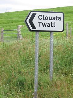
Twatt is a settlement in the parish of Birsay on the Mainland of Orkney, Scotland. It was previously the location of RNAS Twatt, 1940–1949. Twatt is situated at the junction of the A986 and the A967.

Cunningsburgh, formerly also known as Coningsburgh, is a new hamlet and ancient parish in the south of Mainland, Shetland, Scotland. The hamlet is on the coast, nine miles south south west of Lerwick, about halfway between there and Sumburgh Head. The parish was merged with Dunrossness and Sandwick in 1891. It is on the A970 road. There is a primary school, a marina, a community shop, a public hall, a history centre, a touring park, and a United Free Church of Scotland kirk.

Sandwick is a village and an ancient parish in the Shetland Islands, Scotland. It was merged in 1891, along with Cunningsburgh, into Dunrossness. Sandwick is located 13 miles (21 km) south of Lerwick in the South Mainland, and is considered a Tier 1 settlement in Shetland. It comprises a number of distinct settlements in very close proximity to each other, each remaining distinct through being separated by agricultural land. These settlements within Sandwick include Old Sandwick, Leebitton, Broonies' Taing, Stove, Swinister and Hoswick; the latter is almost a village in its own right and is often considered distinct from Sandwick.

The modern names of Scottish islands stem from two main influences. There are many names that derive from the Scottish Gaelic language in the Hebrides and Firth of Clyde. In the Northern Isles most place names have a Norse origin. There are also some island place names that originate from three other influences, including a limited number that are essentially English language names, a few that are of Brittonic origin and some of an unknown origin that may represent a pre-Celtic language. These islands have all been occupied by the speakers of at least three and in many cases four or more languages since the Iron Age, and many of the names of these islands have more than one possible meaning as a result.
Thwaite is a common element of placenames in North West England, and Yorkshire. It is also found elsewhere in England, including two places called Thwaite in Norfolk and one in Suffolk. It is most often found as a suffix. It is a common element of field names, as well as settlement names. It is most frequent in the North West, where some 80 examples are found in Cumberland, at least 30 in Westmorland, about 40 in Lancashire and 30 in the North Riding, whilst it is common in the western parts of the West Riding. Elsewhere in England it is rare, only three examples occurring in the East Riding and seven in Nottinghamshire.