
Grafton is a city in and the county seat of Taylor County, West Virginia, United States, along the Tygart Valley River. The population was 4,729 at the 2020 census. It originally developed as a junction point for the Baltimore and Ohio Railroad, serving numerous branches of a network that was vital to the regional coal industry.

Paul Philippe Cret was a French-born Philadelphia architect and industrial designer. For more than thirty years, he taught at a design studio in the Department of Architecture at the University of Pennsylvania.

The Resettlement Administration (RA) was a New Deal U.S. federal agency created May 1, 1935. It relocated struggling urban and rural families to communities planned by the federal government. On September 1, 1937, it was succeeded by the Farm Security Administration.

Cumberland Mountain State Park is a state park in Cumberland County, Tennessee, in the southeastern United States. The park consists of 1,720 acres (7.0 km2) situated around Byrd Lake, a man-made lake created by the impoundment of Byrd Creek in the 1930s. The park is set amidst an environmental microcosm of the Cumberland Plateau and provides numerous recreational activities, including an 18-hole Bear Trace golf course.

Arthurdale is an unincorporated community in Preston County, West Virginia, United States. It was built in 1933 at the height of the Great Depression as a social experiment to provide opportunities for unemployed local miners and farmers. Arthurdale was undertaken by the short-lived Subsistence Homesteads Division and with the personal involvement of First Lady Eleanor Roosevelt, who used her influence to win government approval for the scheme.
East Dailey is a census-designated place (CDP) in Randolph County, West Virginia, United States. As of the 2010 census, its population was 557. It is located within the Monongahela National Forest adjacent to the Tygart Valley River. East Dailey and its Old Timer's Camp are host to the Elkhenge Music Festival.

Aberdeen Gardens is a national historic district located at Hampton, Virginia, United States. The district was part of a planned community initiated by Hampton University under New Deal legislation. The neighborhood is listed on the Virginia Landmarks Register and the National Register of Historic Places. The district encompasses 157 contributing buildings.

Norvelt is a census-designated place in Mount Pleasant Township, Westmoreland County, Pennsylvania, United States, founded in 1934 as Westmoreland Homesteads. In 1937 it was renamed to honor Eleanor Roosevelt. The community was part of the Calumet-Norvelt CDP for the 2000 census, but was split into the two separate communities of Calumet and Norvelt for the 2010 census. Calumet was a typical company town, locally referred to as a "patch" or "patch town", built by a single company to house coal miners as cheaply as possible. On the other hand, Norvelt was created during the Great Depression by the federal government of the United States as a model community, intended to increase the standard of living of laid-off coal miners. Award winning writer Jack Gantos was born in the village and wrote two books about it

Staunton River State Park is a state park in Virginia. One of the Commonwealth's original state parks, built by the Civilian Conservation Corps and opening in 1936, it is located along the Staunton River near Scottsburg, Virginia. It is an International Dark Sky Park.
Dailey is a census-designated place (CDP) in Randolph County, West Virginia, United States. Dailey is located on U.S. routes 219 and 250, 3 miles (4.8 km) south-southwest of Beverly. Dailey has a post office with ZIP code 26259. As of the 2010 census, its population was 114.

Cumberland Homesteads is a community located in Cumberland County, Tennessee, United States. Established by the New Deal-era Division of Subsistence Homesteads in 1934, the community was envisioned by federal planners as a model of cooperative living for the region's distressed farmers, coal miners, and factory workers. While the cooperative experiment failed and the federal government withdrew from the project in the 1940s, the Homesteads community nevertheless survived. In 1988, several hundred of the community's original houses and other buildings, which are characterized by the native "crab orchard" sandstone used in their construction, were added to the National Register of Historic Places as a historic district.

The Philippi Historic District (PHD) is national historic district located at Philippi, Barbour County, West Virginia, USA. It encompasses 113 contributing buildings and one contributing structure dating from the mid-19th century through early 20th century. The district includes the commercial, ecclesiastical, and civic core of the town situated along the Tygart Valley River.

Nellis Historic District is a national historic district located at Nellis, Boone County, West Virginia. It encompasses 82 contributing buildings, three contributing structures, and one contributing object. The district includes the commercial, ecclesiastical, and residential buildings built by the Nellis Coal Company as a planned community between 1920 and 1955. The community was a model for coal communities in Boone County and the southern coal fields. Included in the district is the Nellis Church / Nellis Archives (1926), stone wall constructed by the Works Progress Administration, coal company storage building, Nellis Company Store and Offices (1922), community bulletin board, Superintendent's House, and clubhouse.
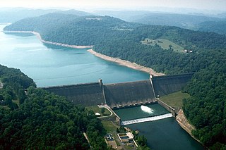
Tygart Dam — also known as Tygart River Dam — is a gravity dam built (1934-38) and operated by the United States Army Corps of Engineers in Taylor County, West Virginia, United States. The dam regulates the waters of the Tygart Valley River. Its storage reservoir is known as Tygart Lake. Most of the lakeshore is occupied by Tygart Lake State Park and Pleasant Creek Wildlife Management Area. The structure was listed on the National Register of Historic Places in 1995.

Jackson's Mill State 4-H Camp Historic District, also known as West Virginia University Jackson's Mill, is a historic 4-H camp and national historic district near Weston, Lewis County, West Virginia. The district includes 23 contributing buildings, 4 contributing sites, 4 contributing structures, and 2 contributing objects. The camp was established in 1921 as the first statewide 4-H camp in the United States. The district includes buildings related to the site's inception as a homestead and agricultural area as well as its current manifestation as a youth camp facility and conference center.

The Subsistence Homesteads Division of the United States Department of the Interior was a New Deal agency that was intended to relieve industrial workers and struggling farmers from complete dependence on factory or agricultural work. The program was created to provide low-rent homesteads, including a home and small plots of land that would allow people to sustain themselves. Through the program, 34 communities were built. Unlike subsistence farming, subsistence homesteading is based on a family member or members having part-time, paid employment. However the new residents were not allowed to purchase the new homes.

Rugby Road–University Corner Historic District is a national historic district located at Charlottesville, Virginia. The district encompasses 173 contributing buildings in the city of Charlottesville. It includes a variety of commercial, residential, and institutional structures mirroring the University of Virginia's development between the 1890s and the Great Depression. It includes properties on Carr's Hill. Notable buildings include the Chancellor Building (1920), the Minor Court Building, Mincer's Shop Building 1920s), the Stevens-Shepherd Building, Buckingham Palace, St. Paul's Episcopal Church (1926–27), Madison Hall (1905), fraternity houses dating from 1902 to 1928, Fayerweather Hall (1893), the Bayly Museum (1934), Faculty Apartments building, Watts-Hillel House (1913-1914), and Hotopp-Watson House (1900). Also located in the district are the separately listed Anderson Brothers Building, Preston Court Apartments, and Wynhurst.

Eagar Townsite Historic District is a section of the town of Eagar, Arizona which has been designated a National Historic Place. Sitting on roughly 54 acres, the site contains 37 structures, 21 of which have historical significance. The period of significance is from 1886, the year the townsite was founded, through 1942, which represents the significant period of development of the town. The site was added to the Register on July 23, 1993.

Middle Valley is an unincorporated community located along Middle Valley Road and County Route 513 in Washington Township, Morris County, New Jersey. It is located near Long Valley within the valley of the South Branch Raritan River. The Middle Valley Historic District was listed on the state and national registers of historic places in 1989 and 1990.


